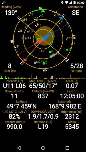
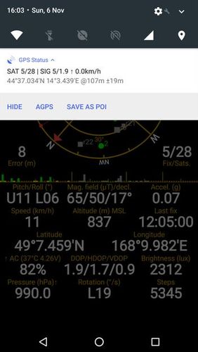
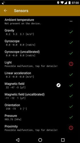
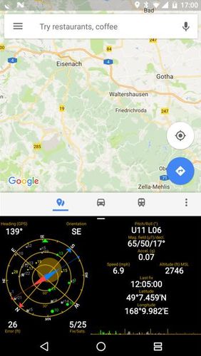
GPS status & toolbox - is a very useful program for working with GPS. This utility is aimed at viewing GPS condition and settings. It can display all data of a sensor and GPS: positions and satellite signal power, accuracy, speed, acceleration, height, step and even battery status.
Game features:
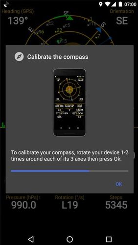
Magnet compass with accurate north
All data of a sensor and GPS
Fast search
Simple and comprehensive interface
Loading video...
Like it? Share with your friends!
Supported operating systems:
Google Android 4.1, Google Android 4.2, Google Android 4.3, Google Android 4.4, Google Android 5.x, Google Android 6.x, Google Android 7.x, Google Android 8.x
Similar Software:
TomTom Poland for Android TomTom Poland for Android - TomTom Poland is a turn-by-turn GPS navigator for Android devices. The app includes accurate offline maps, so you can find your way anywhere, even without an internet connection
DondeEsta - ultimate SMS mobile tracking system! DondeEsta - ultimate SMS mobile tracking system! - LOCATE YOUR FAMILY SIMPLE SENDING SMS
Install the application in the mobile to be located (i.e. your kid's mobile)
Mobile tracking for family safety.
Locate your children.
Locate elderly.
Locate for your own safety.
Easily alert your family when you are in a trouble!
DondeEstaTM brings peace of mind
MySpeed MySpeed will record your speed and location to a log file and show it on a map.
It can use a database of speed camera locations to alert you when you're near a speed camera.
There is no speed camera database included. You'll need to download the data from a site such as scdb.info, flitspaal.nl, pocketgpsworld.com, maparadar.com, etc
Geopaparazzi Geopaparazzi is a tool developed to do fast qualitative technical and scientific surveys. Its strength is its direct connection to the BeeGIS GIS, that can be used to further process the collected data.
Even if the main aim is in the field of surveying, it contains tools that can be of great use also to tourists that want to keep a geo-diary
Path Finder Path Finder is a free Android mobile app built at Paxcel Labs that records your GPS positions while you walk or drive and helps you track and record your routes making it easy to remember your way or where you parked your car or bike
My Tracks My Tracks - Use My Tracks while you run, bike, hike, or do anything else outdoors, and it will use the GPS sensor in your Android phone to record the path you took. It will also gather useful statistics such as time, speed, distance, and elevation. You can review all of this data live, or you can save it for use later
BlueGPS4Droid BlueGPS4Droid is an application for using an external Bluetooth GPS on Android devices.
The application starts a service, then connects to a Bluetooth device (NMEA GPS) and creates a mock GPS provider which can be used to replace the internal GPS.
It's also possible to log the external GPS NMEA data in a file on the device
Pronto Pronto is a simple GPS tracker for outdoor activities, such as walking, running and cycling
My Location Logger My Location Logger - My Location Logger allows you to share your exact location using your Android phone.
If you want to invite friends somewhere but don't know the directions, simply launch the app and send them a message with your GPS coordinates.
Google Maps will allow them to find your location easily
WAY - Where are you? WAY - Where are you? - Share you location and find your friends easily.
Wanna find your friends?
Wanna share your location with friends?
Congratulations: YOU FOUND THE APPLICATION WHICH ALLOWS YOU THAT AND EVEN MORE.
"WAY - Where are you?" allows you to find your friends' locations in real time and/or send them free messages
Comments on GPS status & toolbox:
rob:
Nice
Date: 7 Nov 21
If you noted an error or download link is broken, please, report it via this page or use comments.
GPS status & toolbox is compatible with your device Axioo Picophone M2