Outdoor Share for Android - The Outdoor Navigation software is your best friend through your adventures in the wild.
Go into the outdoors with confidence and enjoy your activities without worrying about the tools to help you navigate. Your Outdoor Navigation app is made by the people who have been developing this software since 2003 across multiple platforms. Be sure that you will stay ahead of the rest with continuous updates and relevant tools.
It is an excellent tool for biking, jogging, skiing, hiking, geocaching, boating, flying and many other sporting activities.
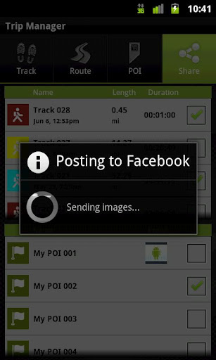
Your Outdoor Share will give you the ability to take those valuable tracks and POIs that you have created with your Outdoor Navigation base application and share them with your Facebook pals by uploading them to your Facebook account.
· Allows to share tracks and POIs with Facebook (besides the sharing via mail that is available also in the base version)
Installation instructions:
Outdoor Share is an add-on for the free Outdoor Navigation application. You need to have your Outdoor Navigation installed to be able to use Outdoor Share.
Download and install Outdoor Share on your Android device. Start the Outdoor Share plugin to complete the license checking: when activation will be completed then the icon will be removed (you need to restart your device to hide the icon) and the plugin will be used inside Outdoor Navigation application.
What's New in This Release:
· Bug fixing
Like it? Share with your friends!
Supported operating systems:
Google Android 10.x, Google Android 2.1, Google Android 2.2, Google Android 2.3, Google Android 3.0, Google Android 3.1, Google Android 3.2, Google Android 4.0, Google Android 4.1, Google Android 4.2, Google Android 4.3, Google Android 4.4, Google Android 5.x, Google Android 6.x, Google Android 7.x, Google Android 8.x, Google Android 9.x
Nöbetçi Eczaneler Ankara Nöbetçi Eczaneler Ankara - Ankara Eczacı Odası'ndan günlük olarak alınan bilgiler doğrultusunda, uygulamamızda ilçenizi seçerek, bölgedeki nöbetçi eczanelerin bilgilerine ulaşabilirsiniz
Osm2GpsMid GpsMid is a free, fully offline, vector based map application for your mobile phone. It displays your current position on a zoomable map and can be used to search for and navigate to roads or points of interest of your liking. As all data is stored in a compact binary format on your mobile phone you will incur no charges for extra data downloads
Run.GPS Trainer UV Run.GPS Trainer is the perfect tool for sports like running, skiing and walking. It uses the Global Positioning System (GPS) to record all of your training parameters like speed, distance and altitude.
Run.GPS Trainer UV is the successor of of the award-winning Run.GPS Trainer software and has tons of new features
2GIS 2 gis - is a useful mobile navigator which allows you to use maps in offline mode after you download data of a certain city. The application will easily help you find the needed address, telephone and working time of organizations and will offer several options regarding the best route
GeoBeagle GeoBeagle is a free, open source application for the Android platform to aid users in finding geocaches and letterboxes. It enables the user to do paperless geocaching.
Geocaches and letterboxes are objects that have been hidden in the real world; the game of geocaching/letterboxing is finding these objects around you
CopsAlarm No more tickets Show where the hiding police are on Google Map As well as speed cam,red light locations Lite shows police,red lights only
EcoDrive Free Speedometer EcoDrive Free Speedometer - EcoDrive Free Speedometer - accurate and convenient GPS speedometer.
The app is designed to control the speed, economy, time, direction, etc.
Real-time economy calculations is based on the speed, acceleration and braking, descents and ascents
GPS Map Camera use GoogleMap GPS Map Camera use GoogleMap - The main feature of the 'GPS Map Camera':
When you take a piture with GPS enabled, it will paste the google map, address and weather to picture. (GPS latitue/longitude also include in the information)
Please enable your network and GPS function before using this application
GoPenS GoPenS is an OpenSource GPS application for Android phones, based on OpenStreetMap (OSM). OpenStreetMap is a collaborative map of the world. Therefore, one of the main functions of the application is to be able to record a trace and send it as a GPX to the OSM servers, and so edit the OSM Map
Other Software by developer «GPS Tuner»:
GPS Tuner Essentials Full Version with BENELUX Basic Map Content GPS Tuner Essentials Full Version with BENELUX Basic Map Content is designed specifically for off-road use: its large buttons, selectable tool window size, multiple Compass views and the built-in Tele Atlas map makes it extremely user-friendly and reliable
GPS Tuner Atlas Full Version with Full Europe Basic Map Content GPS Tuner Atlas Full Version with Full Europe Basic Map Content is designed specifically for off-road use: its large buttons, selectable tool window size, 6 different types of Compass views and the built-in Tele Atlas map makes it extremely user-friendly and reliable
Outdoor Compass for Android Outdoor Compass for Android - The Outdoor Navigation software is your best friend through your adventures in the wild.
Go into the outdoors with confidence and enjoy your activities without worrying about the tools to help you navigate. Your Outdoor Navigation app is made by the people who have been developing this software since 2003 across multiple platforms
Outdoor SOS for Android Outdoor SOS for Android - The Outdoor Navigation software is your best friend through your adventures in the wild.
Go into the outdoors with confidence and enjoy your activities without worrying about the tools to help you navigate. Your Outdoor Navigation app is made by the people who have been developing this software since 2003 across multiple platforms
Outdoor Offline Maps for Android Outdoor Offline Maps for Android - The Outdoor Navigation software is your best friend through your adventures in the wild.
Go into the outdoors with confidence and enjoy your activities without worrying about the tools to help you navigate. Your Outdoor Navigation app is made by the people who have been developing this software since 2003 across multiple platforms
GPS Tuner Essentials Full Version with France, Monaco, Belgium, Switzerland Basic Map Content GPS Tuner Essentials Full Version with France, Monaco, Belgium, Switzerland Basic Map Content is designed specifically for off-road use: its large buttons, selectable tool window size, multiple Compass views and the built-in Tele Atlas map makes it extremely user-friendly and reliable
GPS Tuner Essentials Full Version with United States Basic Map Content GPS Tuner Essentials Full Version with United States Basic Map Content is designed specifically for off-road use: its large buttons, selectable tool window size, multiple Compass views and the built-in Tele Atlas map makes it extremely user-friendly and reliable
GPS Tuner Essentials Full Version with Brazil Basic Map Content GPS Tuner Essentials Full Version with Brazil Basic Map Content is designed specifically for off-road use: its large buttons, selectable tool window size, multiple Compass views and the built-in Tele Atlas map makes it extremely user-friendly and reliable
GPS Tuner Atlas Full Version with Asia Pacific Basic Map Content GPS Tuner Atlas Full Version with Asia Pacific Basic Map Content is designed specifically for off-road use: its large buttons, selectable tool window size, multiple Compass views and the built-in Tele Atlas map makes it extremely user-friendly and reliable
Outdoor Speedometer for Android Outdoor Speedometer for Android - The Outdoor Navigation software is your best friend through your adventures in the wild.
Go into the outdoors with confidence and enjoy your activities without worrying about the tools to help you navigate. Your Outdoor Navigation app is made by the people who have been developing this software since 2003 across multiple platforms

")