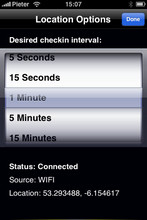
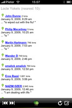
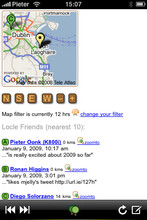
Locle is a mobile application that lets users see where their friends and family are without the need for GPS. Wherever you are, always find out where people are and meet them for lunch, drinks or whatever you want to do. Just make sure you don't miss out on anything.
Like it? Share with your friends!
If you got an error while installing Themes, Software or Games, please, read FAQ.
Supported operating systems:
Google Android 1.0, Google Android 1.5, Google Android 1.6, Google Android 10.x, Google Android 2.0, Google Android 2.1, Google Android 2.2, Google Android 2.3, Google Android 3.0, Google Android 3.1, Google Android 3.2, Google Android 4.0, Google Android 4.1, Google Android 4.2, Google Android 4.3, Google Android 4.4, Google Android 5.x, Google Android 6.x, Google Android 7.x, Google Android 8.x, Google Android 9.x, Java ME, Java Nokia 240x320, Java SE 240x320, Palm OS 3.x, Palm OS 4.x, Palm OS 5.x, Pocket PC 2002, RIM BlackBerry OS 4.0, RIM BlackBerry OS 4.1, RIM BlackBerry OS 4.2, RIM BlackBerry OS 4.3, RIM BlackBerry OS 4.5, RIM BlackBerry OS 4.6, RIM BlackBerry OS 4.7, RIM BlackBerry OS 5.0, RIM BlackBerry OS 6.0, Windows Mobile 2003, Windows Mobile 5.0, Windows Mobile 6 Classic, Windows Mobile 6 Professional, Windows Mobile 6.1 Classic, Windows Mobile 6.1 Professional, Windows Mobile 6.5 Professional
Similar Software:
Vespucci OpenStreetMap Editor Vespucci is the first editor for OpenStreetMap on Android. You can download the map data for a specific area and edit the map. After editing, you can send it directly to the OSM Server.
What's New in This Release:
New features:
· OpenStreetBugs support(disabled by default)
· layers incl
Big Planet TW Solution to Offline Google Maps on Android Phones
BostonBusMap BostonBusMap is an application for Android phones. It uses GPS data provided by the MBTA to plot the real-time location of buses on a map.
What's New in This Release:
· GPS now turns on when you start the app to allow quicker location lookup times
AugSatNav Walk AugSatNav is an augmented reality navigation system which overlays walking directions upon a live video feed of the path or road ahead.
With AugSatNav there is no need to follow instructions or interpret maps - you can simply find your way by walking along the route highlighted by a bright white line
NavStarter NavStarter is a little app that can be used for the Google Navigation Hack to navigate to an address without first creating a shortcut
Map Navigation Map Navigation - detailed maps of cities and countries. Use this application in any place of the world without Internet connection. All data is updated all the time and boots in no time. You can make marks on the maps and send them via e-mail
Map Locate Ad This app is not created to replace Google Maps or other feature rich mapping apps. What this app does is to serve a simple need for certain group of users. Use case is you own jpg,png image files of tradeshow,house,store,apartment,garden etc floorplan and you want to draw pins on different location
Maps on free Maps on free - navigation maps which can be used in offline mode. All you need to do is to download the information to the memory card of your device. You can add files with ready routes and marked orienting points. You don't have to worry about constant Internet connection anymore while travelling
Latitude Launcher Latitude isn't enabled in the UK, and some other countries, on the T-Mobile G1, however it is enabled on many other phones e.g. Nokia N95. This is frustrating, a Google phone without Google Latitude.
Latitude Launcher can enable Latitude for you if you have 'Rooted' your phone


")