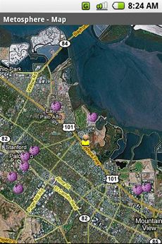
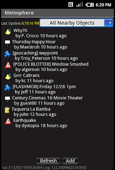
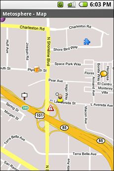
Metosphere Explore and create virtual objects around your physical location like messages, emergency alerts, events, news, reviews, games. View geospatial data from Wikipedia, Eventful, and Upcoming. Start a GeoBlog on your GPS-enabled phone.
This is the core Metosphere Android app. The goal is to follow the Firefox/Eclipse model and provide the ability to create extensions and add-ons like a Geocaching Assistant, Location Messaging Client, Proximity-based KML/GeoRSS Reader, Flash Mob Communicator, Community/Campus Emergency Alert Notifier, or even a Meatspace MUD game.
Like it? Share with your friends!
Supported operating systems:
Google Android 1.0, Google Android 1.5, Google Android 1.6, Google Android 10.x, Google Android 2.0, Google Android 2.1, Google Android 2.2, Google Android 2.3, Google Android 3.0, Google Android 3.1, Google Android 3.2, Google Android 4.0, Google Android 4.1, Google Android 4.2, Google Android 4.3, Google Android 4.4, Google Android 5.x, Google Android 6.x, Google Android 7.x, Google Android 8.x, Google Android 9.x
Similar Software:
Fleet Activity Logger Fleet Activity Logger - Why do you need Fleet Activity Logger application?
- Track your fleet to increase your productivity
- View entire fleet on a single map screen
How to start?
1. Install the application on your Android phone.
2. Create your account by providing your email id, phone number of the device, name, country and submit it.
3
TomTom North America for Android TomTom North America for Android - TomTom North America is a turn-by-turn GPS navigator for Android devices. The app includes accurate offline maps, so you can find your way anywhere, even without an internet connection
GPS Tools GPS Tools - is an application for calibration of a satellite module of your smartphone. The utility uses a magnetic compass, makes changes to the route, speed and accuracy of the displayed data. As soon as the calibration is completed you can track your location with maximum accuracy
GPS Location Lite GPS Location Lite - Use your Android phone as a professional GPS logging device.
Record different tracks and export gpx-files to sdcard.
View Distance, Time, Speed, Altitude, Latitude and Longitude.
In the GPS Location Lite settings you could choose gps or network provider. GPS interval (5-60 seconds) and some other preferences are adjustable
Back2It Back2It is not just a car locator.
With one click, you may mark places like:
- parking lots
- favorite restaurants
- museums
- theaters
- public park
...
and 1 click to go back with GPS navigation on Google Map.
Switch to Google Map for route
Location Manager Location Manager - This unique location app is best described with the following scenarios:
Scenario 1:
I live in an area where the Oregon, California, and Santa Fe Trails all passed through. There are signs everywhere saying, "The trails crossed here"
Gps Maps Gps with Google Map, live current position. Very simple to use. It is the most easy way to know your exactly coordinates. Only 1.2 KB
BlueGPS4Droid BlueGPS4Droid is an application for using an external Bluetooth GPS on Android devices.
The application starts a service, then connects to a Bluetooth device (NMEA GPS) and creates a mock GPS provider which can be used to replace the internal GPS.
It's also possible to log the external GPS NMEA data in a file on the device
Waze Waze is a free, 100% user-generated, social navigation application that allows drivers to build and use live maps & real-time traffic updates to improve their daily commute
Other Software by developer «metosphere.com»:
not found
Comments on Metosphere (Android):
Comments not found
If you noted an error or download link is broken, please, report it via this page or use comments.
Metosphere (Android) is compatible with your device BBK Vivo Y73 Standard Edition Dual SIM TD-LTE CN 32GB V1731CA


")
")