GPS Status & Toolbox - Be a GEEK: Get the most out of your phone. Raw GPS data at your fingertips.
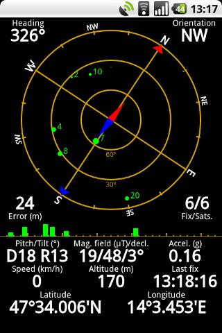
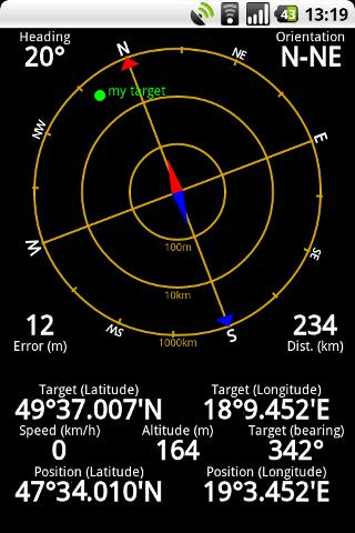
Display your GPS and sensor data: position and signal strength of satellites, accuracy, speed, acceleration, bearing.
Tools included: compass with magnetic and true north, leveling tool, mark or share your location and navigate back later.
Keep your GPS fast: reset it or download A-GPS data regularly for faster fixes.
What's New in This Release:
· Workaround for Nexus S issues.
· aGPS age is correctly displayed (in hours / days).
· Fixed a rounding error in location formatting.
· More instruments for Nexus 7.
· Enhanced landscape layout. All instruments are available in landscape mode, too!
Like it? Share with your friends!
Supported operating systems:
Google Android 1.0, Google Android 1.5, Google Android 1.6, Google Android 10.x, Google Android 2.0, Google Android 2.1, Google Android 2.2, Google Android 2.3, Google Android 3.0, Google Android 3.1, Google Android 3.2, Google Android 4.0, Google Android 4.1, Google Android 4.2, Google Android 4.3, Google Android 4.4, Google Android 5.x, Google Android 6.x, Google Android 7.x, Google Android 8.x, Google Android 9.x
Similar Software:
Navigation gestures Navigation gestures - is an application which will add navigation gestures to any Android device. With this program you will get more useful space of screen. Moreover, with the help of this utility you can set gesture functions and change appearance
CopsAlarm No more tickets Show where the hiding police are on Google Map As well as speed cam,red light locations Lite shows police,red lights only
Connector - Track & Dispatch (Android) Connector - Track & Dispatch (Android) is a cloud-based, Google Apps integrated track and dispatch service.
The service supports a wide range of location-aware devices including smart phones, wireless routers and other GPS devices. It is suitable for businesses and organizations of all sizes as well as for individuals
Android Photo GeoTag Android Photo GeoTag - Take pictures with your mobile phone and incorporate the data of the geographical location. The application allows you to include in the photographs, data from the GPS receiver, along with a brief note. If you know the coordinates, not having the GPS receiver, you can also handwrite geographic data
Osm2GpsMid GpsMid is a free, fully offline, vector based map application for your mobile phone. It displays your current position on a zoomable map and can be used to search for and navigate to roads or points of interest of your liking. As all data is stored in a compact binary format on your mobile phone you will incur no charges for extra data downloads
amAze (Samsung) AmAze is a first of its kind free navigation and local search service. It is free to download and use and it contains wide coverage of maps including aerial photo in Europe, North America, Australia and parts of Asia and Africa
Mobile Tracker Pro Mobile Tracker Pro - Mobile Tracker apps is focused to Android Mobile which can be Tracked after it get lost. When the Android phone get stolen/lost and When the new SIM card is inserted in the mobile, this app begins and automatically sends SMS from the SIM card which is inserted
Phone Tracker (GPS Phone Tracking) Phone Tracker (GPS Phone Tracking) - The Phone Tracker is a free service that uses GPS technology to help you follow friends/family and see their exact location on a map. You will be able to securely track both iPhones and Androids, view their movements, and see up to 72 hours of their travel location history. ✓ Follow your child's movements during the day
FindShip FindShip - Find any ship all over the world! With FindShip, you can track your vessel' movements realtime on the mapFeatures:• * Nearly 80,000 ships online.• * Covering most ports on the world.• * Detail ship's information. In addition to AIS information, D.W.T/Gross ton/Build year is also provided.• * Powerfull ship/port search engine
GPS Tools GPS Tools - is an application for calibration of a satellite module of your smartphone. The utility uses a magnetic compass, makes changes to the route, speed and accuracy of the displayed data. As soon as the calibration is completed you can track your location with maximum accuracy
Other Software by developer «EclipSim Bt.»:
Hungarian for AnySoft Keyboard Kenyelmesen, magyarul irhat az Anysoft Keyboard segitsegevel. Magyar billentyűzet kiosztas es szotar AnySoftKeyboard-hoz. FIGYELEM! Ez egy kiegeszitő, ami csak az eredeti programmal egyutt műkodik. Onalloan nem!


")


")


