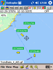
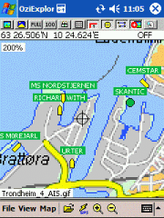
AIS2OZI - AIS2OZI tracks ship positions. It is a logger/decoder/plotter for PocketPC.
Ship positions are plotted directly in OziExplorer Download AIS2OZI (Make backup of Shiplist.txt when reinstalling.)
Decodes AIVDM sentences of types 1, 2, 3 and 5, i.e. position reports for class A shipborne equipment plus vessel information.
Like it? Share with your friends!
If you got an error while installing Themes, Software or Games, please, read FAQ.
Supported operating systems:
Windows Mobile 5.0, Windows Mobile 6 Classic, Windows Mobile 6 Professional, Windows Mobile 6.1 Classic, Windows Mobile 6.1 Professional, Windows Mobile 6.5 Professional
Similar Software:
amAze (Samsung) AmAze is a first of its kind free navigation and local search service. It is free to download and use and it contains wide coverage of maps including aerial photo in Europe, North America, Australia and parts of Asia and Africa
TwitterGPSerer TwitterGPSerer allows you to oAuth update and view Twitter contacts via GPS. You can use the GPS to find your current location and send a tweet and also track your friends via Twitter. The map service is provided by Google.com. The tweet service is provided by Twitter
FON Access Points for Kuwait FON Access Points for Kuwait - FON offers you a new Points of Interest service (POIs). This allows you to download FONspots directly to your navigation device.
What does that mean? You can download a Points of Interest file directly to your navigation device
FON Access Points for Hungary FON Access Points for Hungary - FON offers you a new Points of Interest service (POIs). This allows you to download FONspots directly to your navigation device.
What does that mean? You can download a Points of Interest file directly to your navigation device
LiteTrack LiteTrack is the right tool to record your route, save off-road paths, retrace a way, get your position on the map with detailed gps data (satellite charts, speed and much more)
Marathon Marathon is a Windows Mobile application which keeps track of your movement with the help of a GPS-receiver. It is the perfect companion for sporting activates such as running, skiing or ice skating.
You can configure Marathon to announce various statistics in the headset or speaker while you’re recording
TrackMe TrackMe - Tool that stores GPS positions and uses that information to generate KML files that can be used by Google Earth or Google Maps for displaying realtime or prerecorded tracks.
The data can be stored locally on your PDA or remotely on a server. You can use my server (free of charge) for storing your data
BankGoogler BankGoogler uses the GPS on your PocketPC to find the 50 closest banks (ATMs) sorted via GPS distance. Tap the button to start the GPS and when you get a lock tap on it to view the list of local banks. You can also dial the bank. The GPS maps and bank search service is provided by Google
FON Access Points for Guernsey FON Access Points for Guernsey - FON offers you a new Points of Interest service (POIs). This allows you to download FONspots directly to your navigation device.
What does that mean? You can download a Points of Interest file directly to your navigation device
TravelGPSer TravelGPSer - TravelGPSer uses the GPS on your PocketPC to graphically view your GPS movement. You can adjust the slider for to view larger distances on the map. This uses "The Vincenty inverse formula for ellipsoids" (accuracy to within 0.5mm, or 0.000015").
This program requires that you have both the 'BeanDLL
Other Software by developer «Frank Dahlslett»:
not found
Comments on AIS2OZI:
Comments not found
If you noted an error or download link is broken, please, report it via this page or use comments.


")


