Gps Ski Maps : Chile - Argentina Ski App - for 2011 ski season
Version: 5.2
Platforms: BlackBerry
Categories: Travel & Navigation
Upload date: 25 Dec 11
Developer: BerrySki
License: Shareware
Price: 9.99 $
Downloads: 28
Gps Ski Maps : Chile - Argentina Ski App - for 2011 ski season - Gps Ski Maps for ALL Chile/Argentina Skiing / Snowboarding resorts
Skiing Resort list at the end.The maps subscription is for 2011 ski season
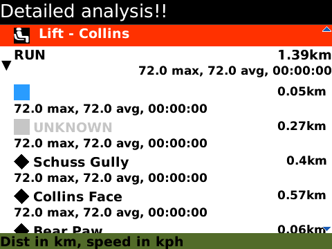
- Instantaneous/Live Trail by Trail analysis right on your phone - only app to do this on BlackBerry®
- Offline GPS ski maps. No internet connection needed once maps are downloaded
*PLZ CHK IF YOUR SKI RESORT/TRAILMAP IS SUPPORTED before getting the app.
Features
* Download map for offline use
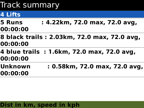
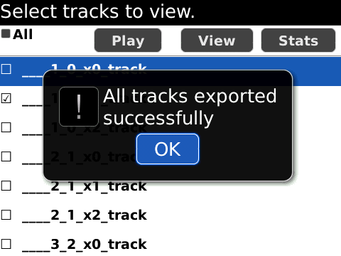
* Ski / Snowboard track analytics/stats - find trail by trail speed,vertical / altitude,distance,time
* Record GPS tracks for skiing
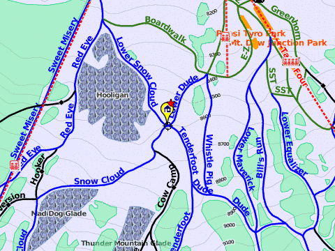
* Gps accurate Ski Trail Map
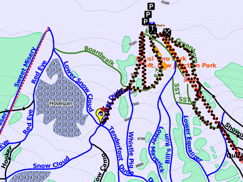
* View tracking overlay
* Pan/zoom/locate yourself on the mountain
* View POIs
* Search mountain
* Live track animation
* Ski tracking summary
*Export tracks/Share on Facebook
*Distance Bearing Tool
*Custom Waypoints
Argentina
=========
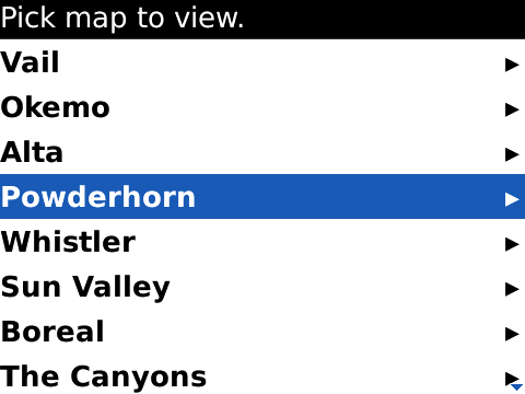
--Catedral Alta Patagonia (Bariloche)
--Las Lena
--Chapelco
Chile
=====
--Portillo
--Termas de Chillan (Nevados de Chillan)
--Three Valleys (Chile) (Valle Nevado, El Colorado, La Parva)
Like it? Share with your friends!
Supported operating systems:
RIM BlackBerry OS 4.1, RIM BlackBerry OS 4.2, RIM BlackBerry OS 4.3, RIM BlackBerry OS 4.5, RIM BlackBerry OS 4.6, RIM BlackBerry OS 4.7, RIM BlackBerry OS 5.0, RIM BlackBerry OS 6.0, RIM BlackBerry OS 7.0, RIM BlackBerry OS 7.1
Similar Software:
J2ME OGC WMS Client J2ME OGC WMS Client is a program for accessing OGC Web map services from Java enabled mobile phone or PDAs.
It accesses the OGC WMS according to WMS 1.1.0 and 1.1.1 specifications and supports zooming and panning in the Map, WMS sublayers, and a bookmark management system for quick access.
Free for non-commercial use
Llama (BlackBerry) Llama has hundreds of US mall directories, including current deals and a store finder for featured malls
GPSed Pro GPSed Pro- is a service for trip tracking from mobile. In real time tracks are traced on Google maps and stored in an online archive. With a simple geotagging feature it is possible to pin photos to a map precisely at a place they were taken
Bing Bing is your central stop for maps, directions, and local searches.
See the quickest route to the airport.
* Get directions to just about anywhere, by car or on foot.
* Browse nearby map locations by category, rating, and distance.
Uncover that hot new shoe store.
* Painlessly find nearby businesses, restaurants, and movie theater showtimes
NavFunPro NavFunPro is the most universal Google-Maps tool that gives you all the goodies of Google Maps and Google Earth. You can connect your Bluetooth GPS or use the mobile's built in GPS. Then NavFunPro turns your mobile into an all-terrain navigation/gps tool. All your tracks are uploaded to internet. You can check them out at www.trackthisout.com/tm
Wayfinder Earth (BlackBerry) Wayfinder Earth (BlackBerry) - The world in your hand! Welcome to the ultimate experience of discovering the earth on your mobile device, for free.
How does it all work?
It's simple. Wayfinder Earth presents you with a 3D globe representing the planet earth, visible on the display of your mobile phone
gps2go gps2go- sends your current GPS coordinates using your BlackBerry device. Upload pictures, send a map to a friend, create groups to allow group tracking that expires after a specified dime. Your phone will capture your GPS position every 5 seconds and transmit them, at a user specified interval, for viewing on Google Map
Foursquare (BlackBerry) Foursquare (BlackBerry) helps you find new ways to explore your city. See where your friends are, learn about the places they frequent and unlock rewards as you travel through the city.
What's New in This Release:
· With version 3
Other Software by developer «BerrySki»:
not found
Comments on Gps Ski Maps : Chile - Argentina Ski App - for 2011 ski season:
Comments not found
If you noted an error or download link is broken, please, report it via this page or use comments.
Gps Ski Maps : Chile - Argentina Ski App - for 2011 ski season is compatible with your device BlackBerry 8110 (Pearl) 4.2

 4.2")


")


")

")
")