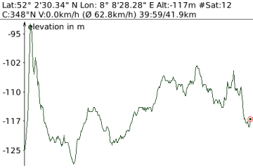
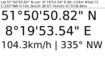
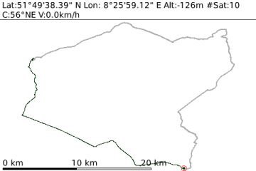
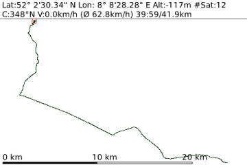
GPSLogger is a pretty straightforward application. It records your physical movement on your BlackBerry device over time, including elevation, speed, and some additional data. GPSLogger can also direct you to a location that you either entered manually or have previously recorded. This is the "Guide me Home" function, which makes GPSLogger usable for Geocaching. As extended functionality to the "Guide Me Home" feature, a very easy to use outdoor navigation is integrated into GPSLogger also.
What's New in This Release:
· Append Logging
· Emergency Alerts
· Sharing Location
· Configurable StatusBar
· Additional new Keyboard shortcuts
· Elevation plausibility check
· Additional information
· The Distance Alert [GPSLogger: Special Options] can be now be configured in the AudioProfile Settings
· Completely rewritten
What's Newin 1.8.0.9:
New:
· Since plenty of user have difficulties to understand how to initially setup GPSLogger some additional information has included into the app in order to make the initial configuration (and the requirements of the app) more transparent to the user
· Links to the online manual have been integrated (hopefully people will read it)
Fixed:
· Torch 9800 OS6.0.0.448 & OS6.0.0.526 fixes
What's New in 1.8.0.4:
· Select between different GPS-Modes: GPS options: Default, Data Optimal (high battery usage, highest accuracy), Response Optimal (high battery usage, good accuracy), MS-Based (medium battery usage, medium accuracy), Standalone (low accuracy), Celltower ("no power" usage, lowest accuracy)
· Please note that Celltower Mode might not be available with all providers (like here in Europe with Vodafone) - but there might be other areas around the world where this will work.
· GPSLogger comes now with a 'Test GPS-Settings' Button which allows you to check if your selected GPS-Mode will work with your device
· The status at the top will also show the current Battery Level in %
· In the General Options you can specify a minimum speed which is required in order that a received location will be recorded (in kmh, mph or nmh)
· GUI-Enhancements like they have been released in all other emacberry.com applications (text input fields with borders - aligned input fields etc.)
Like it? Share with your friends!
Supported operating systems:
RIM BlackBerry OS 4.2, RIM BlackBerry OS 4.3, RIM BlackBerry OS 4.5
Similar Software:
Locify With Locify you can explore interesting places near you from Wikipedia, seek for geocaches, display map where you are (or you want to go), twitter your location, save interesting places from phone or web sync them and even navigate to them... and much more.
Locify is free application for common mobile phone
FON Access Points for Sweden FON Access Points for Sweden - FON offers you a new Points of Interest service (POIs). This allows you to download FONspots directly to your navigation device.
What does that mean? You can download a Points of Interest file directly to your navigation device
FON Access Points for Thailand FON Access Points for Thailand - FON offers you a new Points of Interest service (POIs). This allows you to download FONspots directly to your navigation device.
What does that mean? You can download a Points of Interest file directly to your navigation device
FON Access Points for Macao FON Access Points for Macao - FON offers you a new Points of Interest service (POIs). This allows you to download FONspots directly to your navigation device.
What does that mean? You can download a Points of Interest file directly to your navigation device
FON Access Points for Maldives FON Access Points for Maldives - FON offers you a new Points of Interest service (POIs). This allows you to download FONspots directly to your navigation device.
What does that mean? You can download a Points of Interest file directly to your navigation device
FON Access Points for Zimbabwe FON Access Points for Zimbabwe - FON offers you a new Points of Interest service (POIs). This allows you to download FONspots directly to your navigation device.
What does that mean? You can download a Points of Interest file directly to your navigation device
Garmin Mobile for US & Canada (8800, Monthly) Garmin Mobile for US & Canada (8800, Monthly)- transforms your BlackBerry into a fully functional GPS navigator. Garmin Mobile gives you detailed maps of the United States and Canada, voice-prompted turn-by-turn directions and access to nearly six million points of interest (POIs)
Endomondo Endomondo - Track your workouts using the Endomondo service including location and the amount of calories you have lost from your workout.
With Endomondo on your phone, you can track your running, cycling and other sports. It's fun, it's social and it's motivating
speedOmeter speedOmeter - Every walker, runner or bicycler should have one. A simple program uses BlackBerry integrated GPS receiver to displays speed, distance, time. Lo and Hi speed alerts can pace your workout. If you want to install speedOmeter directly on your BlackBerry handheld, you can get speedOmeter BlackBerry OTA (Over The Air)
FON Access Points for Monaco FON Access Points for Monaco - FON offers you a new Points of Interest service (POIs). This allows you to download FONspots directly to your navigation device.
What does that mean? You can download a Points of Interest file directly to your navigation device
Other Software by developer «emacberry.com»:
FileScout FileScout is a file explorer for BlackBerry smartphones. In addition to its core functionality (browse the file system, create directories, copy, move, rename, zip, unzip, delete files, or open your media files directly, FileScout also allows you to open text files (including .ini, .xml, etc.) so you are able to edit, copy, and paste text segments of text
GPSiesConnect GPSiesConnect - Access GPSies.com directly from your BlackBerry device. Search for tracks for your sports and leisure activities
GPSLogger II GPSLogger II is a pretty straightforward application - it records your physical movement on your BlackBerry device over time. The recorded information includes, beside your actual location data in WGS84, the elevation, your speed and some additional data. You can select between imperial, metric or nautical units


")


