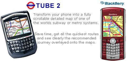
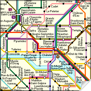
Transform your Blackberry into a fully scrollable detailed map of the Paris Metro system.
Plan journeys on the Paris Metro system, have the quickest routes to hand, with all the details you need including line changes, platform directions and accurate journey times.
See a clear informative display of the route overlaid on the system map. The journey overlay indicates the direction of travel, the colour code of the line your travelling on, and where to make changes along your journey.
Only $10.00
One of a series of Tube 2 product from Visual IT, many cities from all around the world are available.
Like it? Share with your friends!
Supported operating systems:
RIM BlackBerry OS 2.0, RIM BlackBerry OS 3.x, RIM BlackBerry OS 4.0, RIM BlackBerry OS 4.1, RIM BlackBerry OS 4.5, RIM BlackBerry OS 4.6, RIM BlackBerry OS 4.7, RIM BlackBerry OS 5.0
Similar Software:
iCaller Location iCaller Location is a freeware application for Blackberry Smartphone. iCallerLocation shows the area code, city, and state of the incoming caller (United States only) and pinpoints the location on the Blackberry Maps. You will know where the call is coming from within the United States (will cover all cities in North America in the future)
amAze (BlackBerry) AmAze is a first of its kind free navigation and local search service. It is free to download and use and it contains wide coverage of maps including aerial photo in Europe, North America, Australia and parts of Asia and Africa
MetrO (BlackBerry) Métro is your free guide to public transport systems worldwide (about 400 cities covered now)
DCUO Map DCUO Map - DC Universe Online Map - Provides two highly detailed maps of Gotham and Metropolis City
Mundo Terpel Move around Colombia with this application
Gwangju subway Gwangju subway - This is a simple version of viewing subway maps of Gwangju in Korea.
It will be kept updating more functionalities such as route finder, time table and other subway maps
Bing Bing is your central stop for maps, directions, and local searches.
See the quickest route to the airport.
* Get directions to just about anywhere, by car or on foot.
* Browse nearby map locations by category, rating, and distance.
Uncover that hot new shoe store.
* Painlessly find nearby businesses, restaurants, and movie theater showtimes
Wizi Wizi- lets you send an SMS with link to an interactive map with your current location. Its free to use but requires you to have a data connection.
Wizi is a free mobile application that allows you to share your location instantly by SMS and E-Mail. Use Wizi to tell a friend where you are now or where you are going to meet
Geo Mapper Geo Mapper is mapping app that lets you add and edit Locations, Tracks, and Areas. It displays them using online maps supplied by OpenStreet Maps and CloudMade Maps.
As you move around the map it will update keeping your current location in the center of the map. When you pan the map, location updates will be suspended
e-Mobile GPS Companion (8700 series) e-Mobile GPS Companion (8700 series)
Get directions to a point of interest with detailed map from current location to the destination
Other Software by developer «Visual IT»:
Tube 2 Rome (UIQ) Tube 2 Rome (UIQ) - This map package for Tube 2 consists of a fully scrollable detailed map of the Rome metro & rail system.
Plan journeys on this system, list details of the quickest routes and see a superb animated display of your journey tracking around the system map
Tube 2 New York Geo (UIQ) Tube 2 New York Geo (UIQ) - This superb map package for Tube 2 is the ideal map for anyone who needs to get around New York City using the MTA subway system and would like to know just exactly where they are.
The map geographically accurately locates all of Manhattans central stations, overlaid onto a street map
London Master A-Z for iPad London Master A-Z for iPad - This clear and colourful high quality map covers the same area as the market leading A-Z "Master Atlas of Greater London Street Atlas". The familiar look makes this by far the easiest London iPad map to use. The map is drawn by real cartographers with the detailed care and the human touch of emphasis and colour that A-Z are famous for
Edinburgh Mini A-Z Edinburgh Mini A-Z - This street map of Edinburgh covers an area extending to Cramond, Granton, Leith, Portobello, Musselburgh, Whitecraig, Dalkeith, Bonnyrigg (part), Loanhead, Fairmilehead, Juniper Green, Currie, Balerno, and Edinburgh Airport.
Major buildings are colour-coded to indicate places of interest and other buildings that are open to the public
Tube Nottingham Streets Tube Nottingham Streets - A complete street map of central Nottingham for your Palm device using superb map tiles from the famous A-Z map company.
These maps plug directly into our new Tube engine and are a convenient replacement for your paperback A-Z. Never get lost in Nottingham again
Tube 2 Miami (UIQ) Tube 2 Miami (UIQ) - This map package for Tube 2 consists of a fully scrollable detailed map of the Miami metro & rail system.
Plan journeys on this system, list details of the quickest routes and see a superb animated display of your journey tracking around the system map
Tube Montreal (Palm OS) Tube Montreal (Palm OS) - An award winning and highly acclaimed Palm OS application that guides you around the metro system of Montreal. An essential addition to your Palm device for locals and tourists alike.
Tube's features include:
A detailed clear colour map of the Montreal metro system fully scrollable.
Quick find station utility
Barcelona Metro for iPad by Zuti Barcelona Metro for iPad by Zuti - This Zuti application contains a visually unique map of the Barcelona transport system and a superb animated journey planner to help you get around the TMB (Transports Metropolitan de Barcelona), FGC (Ferrocarrils de la Generalitat de Catalunya) Metro and Tram services
Tube 2 Hong Kong (UIQ3) Tube 2 Hong Kong (UIQ3) - This map package for Tube 2 consists of a fully scrollable detailed map of the Hong Kong metro & rail system.
Plan journeys on this system, list details of the quickest routes and see a superb animated display of your journey tracking around the system map
Rough Guides Map Paris Rough Guides Map Paris... These guides are a series of fantastic interactive maps.
Produced in conjunction with the premier travel publisher Rough Guides.
Discover and explore Paris using full colour interactive linked maps, in this simple to use PDA version of The Rough Guides Paris
")
")


 Transform your Blackberry into a fully scrollable detailed map of the Paris Metro system.
")
")


")
")
")


")
")

")
