amAze (BlackBerry) is a first of its kind free navigation and local search service. It is free to download and use and it contains wide coverage of maps including aerial photo in Europe, North America, Australia and parts of Asia and Africa.
With amAze you get all these options and more:
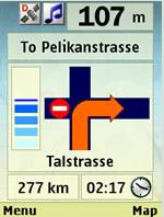
* Visual and voice guidance to any destination
* Search or define any location by its address
* Search and navigate to businesses listed in local search directories (where available)
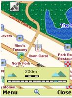
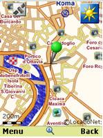
* Present any required location on the map
* View and use dynamic high quality maps at various scales
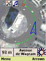
* View and navigate over high resolution satellite images
* Calculate the fastest way between two locations
* Save and manage personal favorites list
* Worldwide weather
amAze enables to calculate the route of a journey to any address or point of interest. Bluetooth connection with a GPS receiver will indicate your location along the route with vocal and graphical guidance to your destination in the shortest possible way. amAze is a collaborative effort led by LocatioNet Systems Ltd., together with some leading vendors in the fields of mapping, local search directories and other geographically related content.
Like it? Share with your friends!
Supported operating systems:
RIM BlackBerry OS 4.5, RIM BlackBerry OS 4.6, RIM BlackBerry OS 4.7, RIM BlackBerry OS 5.0, RIM BlackBerry OS 6.0
Similar Software:
London DK Eyewitness Top 10 Travel Guide & Map (BlackBerry) London DK Eyewitness Top 10 Travel Guide & Map (BlackBerry)- From the top 10 ways to experience Royal London to the top 10 shops, pubs and hotels - this guide features the insider knowledge that every visitor needs, plus London maps and metro maps.
Capture the essence of London, from shopping in Harrods to the Changing of the Guard at Buckingham Palace
Spot for BlackBerry Spot combines your BlackBerry and Bluetooth GPS receiver into the most powerful positioning tool
부산지하철 부산지하철 - This is a simple version of viewing subway maps of Seoul in Korea.
It will be kept updating more functionalities such as route finder, time table and other subway maps
Metro Maps Metro Maps- Find you way through complicated metro in major cities. The developer is currently giving away 3 metro city maps from major cities. I'm sure more maps will be available as his work progresses with the development of the software. The software works great with my blackberry, so far I was able to test out the New York Metro Map
Metro y Metrobus de México Metro y Metrobus de México - This application displays maps with zoom of the Metro, Metrobus, Mexibus, Suburban and Tren Ligero from Mexico City, Guadalajara y Monterrey In short it is an essential application for every inhabitant of the city
BigTinCan Mapper BigTinCan Mapper- Mapper is a cool app that let you take part in the global OSM community and "map your world" by adding Points of Interest (POIs) easily and quickly from a smartphone whenever and wherever you are
gps2go gps2go- sends your current GPS coordinates using your BlackBerry device. Upload pictures, send a map to a friend, create groups to allow group tracking that expires after a specified dime. Your phone will capture your GPS position every 5 seconds and transmit them, at a user specified interval, for viewing on Google Map
대전지하철 대전지하철 - This is a simple version of viewing subway maps of Daejeon in Korea.
It will be kept updating more functionalities such as route finder, time table and other subway maps
Madrid DK Eyewitness Top 10 Travel Guide & Map (BlackBerry) Madrid DK Eyewitness Top 10 Travel Guide & Map (BlackBerry)- From the Palaciao Real to the green Retiro park - the 10 best of everything to see, buy, do, taste and avoid in Madrid, plus maps and Metro map
Live Search for BlackBerry Live Search for BlackBerry - Turn your BlackBerry phone into a map, phone book, or city guide.
Find it.
Find local businesses, restaurants, and shopping in your neighborhood or where you travel.
Map it.
Get maps and detailed driving directions, and track your real-time location with optional GPS integration.
Plan it
Other Software by developer «LocatioNet Systems Ltd.»:
amAze (LG) AmAze is a first of its kind free navigation and local search service. It is free to download and use and it contains wide coverage of maps including aerial photo in Europe, North America, Australia and parts of Asia and Africa
amAze (Sony Ericsson) AmAze is a first of its kind free navigation and local search service. It is free to download and use and it contains wide coverage of maps including aerial photo in Europe, North America, Australia and parts of Asia and Africa
amAze (Samsung) AmAze is a first of its kind free navigation and local search service. It is free to download and use and it contains wide coverage of maps including aerial photo in Europe, North America, Australia and parts of Asia and Africa
amAze (Samsung) AmAze is a first of its kind free navigation and local search service. It is free to download and use and it contains wide coverage of maps including aerial photo in Europe, North America, Australia and parts of Asia and Africa
amAze (Philips) First of its kind free navigation and local search service. It is free to download and use and it contains wide coverage of maps including aerial photo in Europe, North America, Australia and parts of Asia and Africa
amAze (Sonim) AmAze is a first of its kind free navigation and local search service. It is free to download and use and it contains wide coverage of maps including aerial photo in Europe, North America, Australia and parts of Asia and Africa
amAze (Windows Mobile) AmAze is a first of its kind free navigation and local search service. It is free to download and use and it contains wide coverage of maps including aerial photo in Europe, North America, Australia and parts of Asia and Africa
amAze (Sanyo) First of its kind free navigation and local search service. It is free to download and use and it contains wide coverage of maps including aerial photo in Europe, North America, Australia and parts of Asia and Africa
amAze GPS (iPhone/iPad) amAze GPS includes turn-by-turn voice guided navigation with worldwide street maps, full topographic map coverage of the USA and satellite imagery for 200 major cities around the world. Initial download includes a free license to view maps and search for POI around the world
")
")
")
")


")
")
")
")
")
")
")
")
")
")