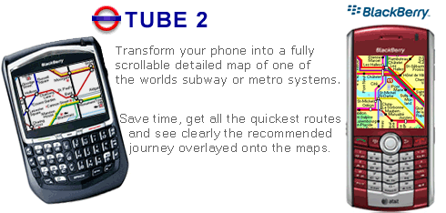
Transform your Blackberry into a fully scrollable detailed map of the New York City MTA subway system.
Plan journeys on the New York City subway system, have the quickest routes to hand, with all the details you need including line changes, platform directions and accurate journey times.
See a clear informative display of the route overlaid on the system map. The journey overlay indicates the direction of travel, the colour code of the line your travelling on, and where to make changes along your journey.
Only $10.00
One of a series of Tube 2 product from Visual IT, many cities from all around the world are available.
Like it? Share with your friends!
Supported operating systems:
RIM BlackBerry OS 2.0, RIM BlackBerry OS 3.x, RIM BlackBerry OS 4.0, RIM BlackBerry OS 4.1, RIM BlackBerry OS 4.5, RIM BlackBerry OS 4.6, RIM BlackBerry OS 4.7, RIM BlackBerry OS 5.0
PlayTube London Tube map
London Tube line status
Next train at the platform
Enjoy !
MindBerry 1.2.0 MindBerry 1.2.0 is a mind-mapping software for BlackBerry smartphones. It's the ideal software for organize your thoughts, manage information overload, increase your productivity and creativity. Capture and organize your ideas at any moment, do it visually with MindBerry
Tokyo Disneyland Locations Tokyo Disneyland Locations - This app adds Tokyo Disneyland Locations to BlackBerry®'s default map.
Press "P" or "N" on keyboards to switch locations after selecting "Invoke Attractions." from Menu.
You can select "Start GPS Navigation", "Add to Favorites", and other options
J2ME OGC WMS Client J2ME OGC WMS Client is a program for accessing OGC Web map services from Java enabled mobile phone or PDAs.
It accesses the OGC WMS according to WMS 1.1.0 and 1.1.1 specifications and supports zooming and panning in the Map, WMS sublayers, and a bookmark management system for quick access.
Free for non-commercial use
Maps (-) Maps (-) - Offline maps. Cache maps to SD card and use them when traveling without network coverage. Ads supported version
Garmap for Mobile Garmap for Mobile - Search, share and navigate! Garmap for Mobile is a free, proudly South African mobile navigation application with local search powered by Yellow Pages and Facebook /Twitter/SMS sharing
PLUS MAP PLUS MAP - Plus Map is an application which helps users in viewing the maps from North to South Highways. Other
than that, it allows users to view other services or facilities along the expressway such as the Toll Plaza, Rest Service Area (RSA), Lay by Auto Teller Machine (ATM) and Petrol Station
Wayfinder Earth (BlackBerry) Wayfinder Earth (BlackBerry) - The world in your hand! Welcome to the ultimate experience of discovering the earth on your mobile device, for free.
How does it all work?
It's simple. Wayfinder Earth presents you with a 3D globe representing the planet earth, visible on the display of your mobile phone
Best Route Enter a starting location and multiple places into the app and select your method of transportation: by car or walking. A route is calculated for you and displayed on the built-in Google Map, showing you the best way to get to all those places
Other Software by developer «Visual IT»:
London Congestion Charge Map (UIQ3) London Congestion Charge Map (UIQ3) - This map package is an essential addition to your Tube 2 maps if you drive in or around central London.
This reference map gives you a clear view of the area now covered by the congestion charge system, complete with a quick find utility to help you find any major road or street in and around the area
Digital Camera Guide (Palm OS) Digital Camera Guide (Palm OS) - An essential guide for anyone new to the world of digital photography. In a simple easy to read format with superb photographs it helps you to get the most from your camera and explains how many of the complicated features of your camera work.
Index of subjects covered:
- Camera Controls
Tube 2 Boston (UIQ) Tube 2 Boston (UIQ) - This map package for Tube 2 consists of a fully scrollable detailed map of the Boston metro & commuter rail system.
It includes all city metro lines along with the MBTA commuter rail system and also includes the five commuter boat routes which cross the bay
Tube Frankfurt (Palm OS) Tube Frankfurt (Palm OS) - An award winning and highly acclaimed Palm OS application that guides you around the metro (S-Bahn / U-Bahn) system of Frankfurt. An essential addition to your Palm device for locals and tourists alike.
Tube's features include:
A detailed clear colour (or grey scale) map of the transport system fully scrollable.
Quick find station utility
Tube 2 Madrid Pro (Palm OS) Tube 2 Madrid Pro (Palm OS) - This map package for Tube 2 consists of a fully scrollable detailed map of the Madrid metro system and linked street maps of central Madrid.
Plan journeys on the metro system, list details of the quickest routes and see a superb animated display of your journey tracking around the system map
Tube 2 Berlin (UIQ3) Tube 2 Berlin (UIQ3) - This map package for Tube 2 consists of a fully scrollable detailed map of the Berlin Metro (U-Bahn/S-Bahn).
Plan journeys on this system, list details of the quickest routes and see a superb animated display of your journey tracking around the system map.
Berlin is the capital and largest city in Germany
Tube 2 Munich (Palm OS) Tube 2 Munich (Palm OS) - This map package for Tube 2 consists of a fully scrollable detailed map of the Munich metro, rail & tram system.
Plan journeys on this system, list details of the quickest routes and see a superb animated display of your journey tracking around the system map.
Munich is the capital city of Bavaria, the southern most German federal state
Tube 2 Paris Touristic (UIQ3) Tube 2 Paris Touristic (UIQ3) - This map package for Tube 2 is the ideal map for the tourist or business traveller who needs to get around Paris using the metro system and would like to know just exactly where they are. The map geographically locates all the central stations, making it much more informative than the official topological map
Paris Metro by Zuti Paris Metro by Zuti - This Zuti application contains a visually unique map of the Paris transport system and a superb animated journey planner to help you get around the Metro, RER, SNCF, Tram, Tvm, and Vogueo services. Now revised and updated to include a larger geographic area which covers more of the outlying areas surrounding Paris
Vienna Metro 10 Vienna Metro 10 - This Zuti application contains a visually unique map of Vienna's transport systems and a superb animated journey planner to help you get around the Metro (U-Bahn), Suburban Rail (S-Bahn) and Tram (Stragenbahn)

")
")


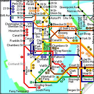 Transform your Blackberry into a fully scrollable detailed map of the New York City MTA subway system.


")


")

")
")
")
")
")
")
")
")

