amAze (BlackBerry) is a first of its kind free navigation and local search service. It is free to download and use and it contains wide coverage of maps including aerial photo in Europe, North America, Australia and parts of Asia and Africa.
With amAze you get all these options and more:
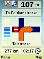
* Visual and voice guidance to any destination
* Search or define any location by its address
* Search and navigate to businesses listed in local search directories (where available)
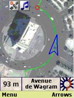
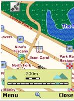
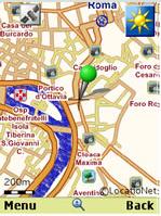
* Present any required location on the map
* View and use dynamic high quality maps at various scales
* View and navigate over high resolution satellite images
* Calculate the fastest way between two locations
* Save and manage personal favorites list
* Worldwide weather
amAze enables to calculate the route of a journey to any address or point of interest. Bluetooth connection with a GPS receiver will indicate your location along the route with vocal and graphical guidance to your destination in the shortest possible way. amAze is a collaborative effort led by LocatioNet Systems Ltd., together with some leading vendors in the fields of mapping, local search directories and other geographically related content.
Like it? Share with your friends!
Supported operating systems:
RIM BlackBerry OS 4.5, RIM BlackBerry OS 4.6, RIM BlackBerry OS 4.7, RIM BlackBerry OS 5.0, RIM BlackBerry OS 6.0
Similar Software:
TrackMyJourney (BlackBerry) TrackMyJourney (BlackBerry) is a mobile application that uses GPS data to provide a number of functions, including navigation, location tracking, map display and route plotting. It receives its location coordinates by communicating via Bluetooth with a separate GPS receiver, or via the phones internal GPS if supported
DCUO Map DCUO Map - DC Universe Online Map - Provides two highly detailed maps of Gotham and Metropolis City
Spot for BlackBerry Spot combines your BlackBerry and Bluetooth GPS receiver into the most powerful positioning tool
NavFunPro NavFunPro - NavFun Pro is the ideal navigation/maps tool that gives you all the goodies of a full featured GPS receiver and Google Maps, Earth, Terrain. Ideal for hiking, geocaching, skiing, mountain biking, and city tours
gps2go gps2go- sends your current GPS coordinates using your BlackBerry device. Upload pictures, send a map to a friend, create groups to allow group tracking that expires after a specified dime. Your phone will capture your GPS position every 5 seconds and transmit them, at a user specified interval, for viewing on Google Map
Sanoodi SMap GPS tracking Sanoodi SMap GPS tracking- NOW WITH IMPROVED TWITTER integration ! SMap GPS tracking app, share routes on Twitter and Sanoodi.com
Features:
- Two screens: a Pace Screen and a route Summary Screen
World Wonders HD Free (BlackBerry) World Wonders HD Free (BlackBerry) - Finally, in one list, the world's "top" everything:
· The world's fastest...
· The world's tallest...
· The world's most expensive...
· The world's longest..
Mappy - Maps & Local serach: Simplify your life with maps and local search, you'll discorver what's around you
- Directions: Plan your route from your position or by entering addresses directly by car, pedestrian, bike or public transit
Wizi Wizi- lets you send an SMS with link to an interactive map with your current location. Its free to use but requires you to have a data connection.
Wizi is a free mobile application that allows you to share your location instantly by SMS and E-Mail. Use Wizi to tell a friend where you are now or where you are going to meet
TUBE 2 Paris (Blackberry) TUBE 2 Paris (Blackberry)
Tube 2 Paris
Transform your Blackberry into a fully scrollable detailed map of the Paris Metro system.
Plan journeys on the Paris Metro system, have the quickest routes to hand, with all the details you need including line changes, platform directions and accurate journey times
Other Software by developer «LocatioNet Systems Ltd.»:
amAze (Android) AmAze is a first of its kind free navigation and local search service. It is free to download and use and it contains wide coverage of maps including aerial photo in Europe, North America, Australia and parts of Asia and Africa
amAze (Sanyo) First of its kind free navigation and local search service. It is free to download and use and it contains wide coverage of maps including aerial photo in Europe, North America, Australia and parts of Asia and Africa
amAze (Sony Ericsson) AmAze is a first of its kind free navigation and local search service. It is free to download and use and it contains wide coverage of maps including aerial photo in Europe, North America, Australia and parts of Asia and Africa
amAze (LG) AmAze is a first of its kind free navigation and local search service. It is free to download and use and it contains wide coverage of maps including aerial photo in Europe, North America, Australia and parts of Asia and Africa
amAze (Philips) First of its kind free navigation and local search service. It is free to download and use and it contains wide coverage of maps including aerial photo in Europe, North America, Australia and parts of Asia and Africa
amAze (Sony Ericsson) AmAze is a first of its kind free navigation and local search service. It is free to download and use and it contains wide coverage of maps including aerial photo in Europe, North America, Australia and parts of Asia and Africa
amAze (Motorola) AmAze is a first of its kind free navigation and local search service. It is free to download and use and it contains wide coverage of maps including aerial photo in Europe, North America, Australia and parts of Asia and Africa
amAze (Samsung) AmAze is a first of its kind free navigation and local search service. It is free to download and use and it contains wide coverage of maps including aerial photo in Europe, North America, Australia and parts of Asia and Africa
amAze (Samsung) AmAze is a first of its kind free navigation and local search service. It is free to download and use and it contains wide coverage of maps including aerial photo in Europe, North America, Australia and parts of Asia and Africa
amAze (Motorola) AmAze is a first of its kind free navigation and local search service. It is free to download and use and it contains wide coverage of maps including aerial photo in Europe, North America, Australia and parts of Asia and Africa

")
")
")


")


")
")
")
")
")
")
")
")
")
")
")