Gps Ski Maps : Chile - Argentina Ski App - for 2011 ski season
Version: 5.2
Platforms: BlackBerry
Categories: Travel & Navigation
Upload date: 25 Dec 11
Developer: BerrySki
License: Shareware
Price: 9.99 $
Downloads: 28
Gps Ski Maps : Chile - Argentina Ski App - for 2011 ski season - Gps Ski Maps for ALL Chile/Argentina Skiing / Snowboarding resorts
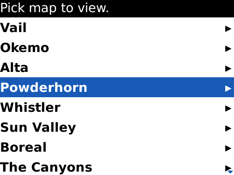
Skiing Resort list at the end.The maps subscription is for 2011 ski season
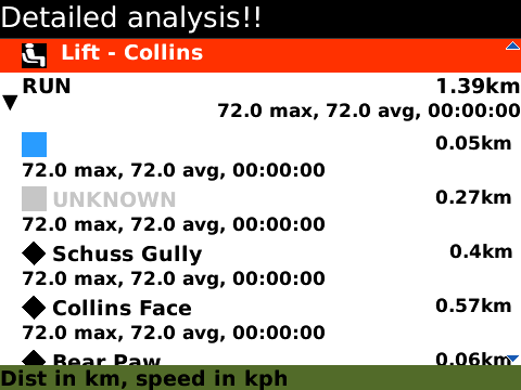
- Instantaneous/Live Trail by Trail analysis right on your phone - only app to do this on BlackBerry®
- Offline GPS ski maps. No internet connection needed once maps are downloaded
*PLZ CHK IF YOUR SKI RESORT/TRAILMAP IS SUPPORTED before getting the app.
Features
* Download map for offline use
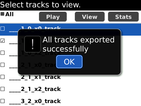
* Ski / Snowboard track analytics/stats - find trail by trail speed,vertical / altitude,distance,time
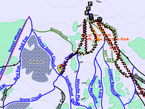
* Record GPS tracks for skiing
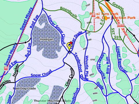
* Gps accurate Ski Trail Map
* View tracking overlay
* Pan/zoom/locate yourself on the mountain
* View POIs
* Search mountain
* Live track animation
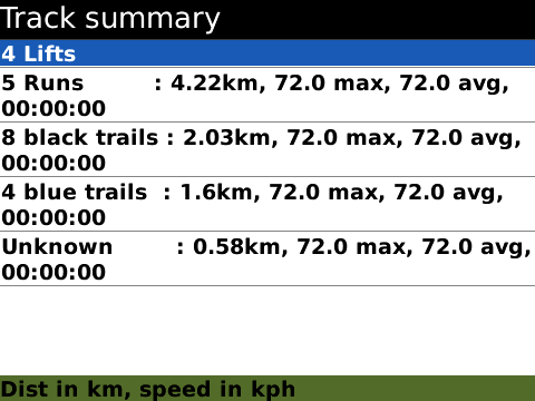
* Ski tracking summary
*Export tracks/Share on Facebook
*Distance Bearing Tool
*Custom Waypoints
Argentina
=========
--Catedral Alta Patagonia (Bariloche)
--Las Lena
--Chapelco
Chile
=====
--Portillo
--Termas de Chillan (Nevados de Chillan)
--Three Valleys (Chile) (Valle Nevado, El Colorado, La Parva)
Like it? Share with your friends!
Supported operating systems:
RIM BlackBerry OS 4.1, RIM BlackBerry OS 4.2, RIM BlackBerry OS 4.3, RIM BlackBerry OS 4.5, RIM BlackBerry OS 4.6, RIM BlackBerry OS 4.7, RIM BlackBerry OS 5.0, RIM BlackBerry OS 6.0, RIM BlackBerry OS 7.0, RIM BlackBerry OS 7.1
Similar Software:
Metro y Metrobus de México Metro y Metrobus de México - This application displays maps with zoom of the Metro, Metrobus, Mexibus, Suburban and Tren Ligero from Mexico City, Guadalajara y Monterrey In short it is an essential application for every inhabitant of the city
Gwangju subway Gwangju subway - This is a simple version of viewing subway maps of Gwangju in Korea.
It will be kept updating more functionalities such as route finder, time table and other subway maps
HelloWorld GPS Map Browser HelloWorld Browser let's you browse Google Maps on your handheld. You can search for a location, search for directions, find a business and view satellite imagery. An essential tool for the professional on the go. Never be lost again!
You can trial HelloWorld for free, so please try before you buy
Rand McNally Traffic - 1 Year Service Rand McNally Traffic - 1 Year Service - Overview - Rand McNally Traffic puts you in control. It helps you plan, anticipate and arrive worry free. Get real-time traffic updates on your mobile phone. Know about traffic on your specific route ... before it's too late
GPSed Pro GPSed Pro- is a service for trip tracking from mobile. In real time tracks are traced on Google maps and stored in an online archive. With a simple geotagging feature it is possible to pin photos to a map precisely at a place they were taken
Garmin Mobile for US & Canada Garmin Mobile for US & Canada- transforms your BlackBerry into a fully functional GPS navigator. Garmin Mobile gives you detailed maps of the United States and Canada, voice-prompted turn-by-turn directions and access to nearly six million points of interest (POIs)
MetrO MetrO is your free guide to public transport systems worldwide (about 400 cities covered now).
· Fully assisted station search (various lists selection or text entry options)
· Station list for each line
· Recently used stations history
· Operating hours management (in selected cities)
· Places of interest: tourism, night life, ..
GEOrendr GEOrendr is a great way to discover and use maps. Maps come to life in GEOrendr. Tap on the map or use your current location and discover information about what you see. Find community hosted maps from ArcGIS Online - ESRI’s online GIS. Alternatively you can use the authoring tools on ArcGIS.com to create your own maps that can be used in GEOrendr
TopoExplorer for Touch Screen Devices ONLY TopoExplorer for Touch Screen Devices ONLY
Features | Free Download
With TopoExplorer you will discover your surroundings on topographic maps even in remote areas assisted by GPS and without the need of the wireless network connection
Super Duper Survey Super Duper Survey is an easy to use application to take and report surveys. It's designed as a self contained, offline application perfect for street surveys
Other Software by developer «BerrySki»:
not found
Comments on Gps Ski Maps : Chile - Argentina Ski App - for 2011 ski season:
Comments not found
If you noted an error or download link is broken, please, report it via this page or use comments.
Please, select device to check if Gps Ski Maps : Chile - Argentina Ski App - for 2011 ski season supports it