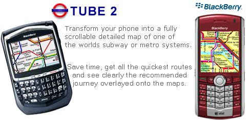
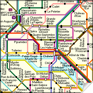
Transform your Blackberry into a fully scrollable detailed map of the Paris Metro system.
Plan journeys on the Paris Metro system, have the quickest routes to hand, with all the details you need including line changes, platform directions and accurate journey times.
See a clear informative display of the route overlaid on the system map. The journey overlay indicates the direction of travel, the colour code of the line your travelling on, and where to make changes along your journey.
Only $10.00
One of a series of Tube 2 product from Visual IT, many cities from all around the world are available.
Like it? Share with your friends!
Supported operating systems:
RIM BlackBerry OS 2.0, RIM BlackBerry OS 3.x, RIM BlackBerry OS 4.0, RIM BlackBerry OS 4.1, RIM BlackBerry OS 4.5, RIM BlackBerry OS 4.6, RIM BlackBerry OS 4.7, RIM BlackBerry OS 5.0
Similar Software:
Wikitude for OS6 Wikitude World Browser finds cool people, places and things. As a BBM connected app Wikitude allows you to see your friends on a map, only if they share their location. Check out your surroundings, meet other BBM users and make new friends
Wayfaring Wayfaring brings the world in your hands! Wayfaring is an application that makes you a globetrotter while sitting in the comfort of your couch. Wayfaring is for those who love traveling but are not able to go to places they long for
Gwangju subway Gwangju subway - This is a simple version of viewing subway maps of Gwangju in Korea.
It will be kept updating more functionalities such as route finder, time table and other subway maps
TopoExplorer for Touch Screen Devices ONLY TopoExplorer for Touch Screen Devices ONLY
Features | Free Download
With TopoExplorer you will discover your surroundings on topographic maps even in remote areas assisted by GPS and without the need of the wireless network connection
Spot for BlackBerry Spot combines your BlackBerry and Bluetooth GPS receiver into the most powerful positioning tool
NavFunPro NavFunPro is the most universal Google-Maps tool that gives you all the goodies of Google Maps and Google Earth. You can connect your Bluetooth GPS or use the mobile's built in GPS. Then NavFunPro turns your mobile into an all-terrain navigation/gps tool. All your tracks are uploaded to internet. You can check them out at www.trackthisout.com/tm
World Wonders Free (BlackBerry) World Wonders Free (BlackBerry) - Finally, in one list, the world's "top" everything:
· The world's fastest...
· The world's tallest...
· The world's most expensive...
· The world's longest..
TrekBuddy Trekbuddy is a J2ME application to be used with a GPS receiver. It is designed to work with every Java-enabled device. It features capabilities such as: * GPS tracking and simple navigation * bitmap maps (without zoom, you can store bitmap maps with different resolution instead)
Bing Bing is your central stop for maps, directions, and local searches.
See the quickest route to the airport.
* Get directions to just about anywhere, by car or on foot.
* Browse nearby map locations by category, rating, and distance.
Uncover that hot new shoe store.
* Painlessly find nearby businesses, restaurants, and movie theater showtimes
Yelp Yelp is the fun and easy way to find reviews and talk about what's great and not so great in your area
Other Software by developer «Visual IT»:
Tube 2 Atlanta (UIQ3) Tube 2 Atlanta (UIQ3) - This map package for Tube 2 consists of a fully scrollable detailed map of the Atlanta rail system.
Plan journeys on this system, list details of the quickest routes and see a superb animated display of your journey tracking around the system map
Tube London City Streets (2009 Edition) Tube London City Streets
This Tube package consists of a fully scrollable detailed map of the London Underground system and 9 linked GPS enabled A-Z street maps.
Plan journeys on the London Underground system, list details of the quickest routes and see a superb animated display of your journey tracking around the system map
Tube Montreal (Series 60) Tube Montreal (Series 60) - Our highly acclaimed Tube application that guides you around the metro system of Montreal is now available for your Series 60 Symbian powered phone. An essential addition to your phone for locals and tourists alike.
· A detailed clear colour map of the Montreal metro system fully scrollable.
· Quick find station utility
Tube 2 Chicago Pro (UIQ) Tube 2 Chicago Pro (UIQ) - This map package for Tube 2 consists of a fully scrollable detailed map of the Chicago metro & commuter rail system and linked street maps of central Chicago.
Plan journeys on the metro system, list details of the quickest routes and see a superb animated display of your journey tracking around the system map
Vienna Metro 10 Vienna Metro 10 - This Zuti application contains a visually unique map of Vienna's transport systems and a superb animated journey planner to help you get around the Metro (U-Bahn), Suburban Rail (S-Bahn) and Tram (Stragenbahn)
GB Major Road Atlas (UIQ) GB Major Road Atlas (UIQ) - This map package is an essential addition to your Tube 2 maps if you drive in and around Great Britain.
This reference map gives you a clear view of all the major roads in the whole of Great Britain, you can use the quick find feature to locate any of the 30,000 + GB towns and villages in the database
Tube 2 Amsterdam Pro (UIQ3) Tube 2 Amsterdam Pro (UIQ3) - This map package for Tube 2 consists of a fully scrollable detailed map of the Amsterdam tram & metro system and linked street maps of central Amsterdam.
Plan journeys on the tram & metro system, list details of the quickest routes and see a superb animated display of your journey tracking around the system map
Tube 2 Hong Kong (Palm OS) Tube 2 Hong Kong (Palm OS) - This map package for Tube 2 consists of a fully scrollable detailed map of the Hong Kong metro & rail system.
Plan journeys on this system, list details of the quickest routes and see a superb animated display of your journey tracking around the system map
London Bus Free London Bus Free - The new Zuti London Bus map has finally arrived, making it easy to travel by bus anywhere in central London. This clear and colourful map covers a detailed street level area of 6 miles by 4 miles and includes over 1300 bus stops and 189 bus routes
Tube 2 Washington Pro (Palm OS) Tube 2 Washington Pro (Palm OS) - This map package for Tube 2 consists of a fully scrollable detailed map of the Washington D.C. metro system and linked high quality street maps of central Washington D.C.
Plan journeys on the metro system, list details of the quickest routes and see a superb animated display of your journey tracking around the system map

")
")


 Transform your Blackberry into a fully scrollable detailed map of the Paris Metro system.


")


")
")
")
")

")
")
")

")