amAze (BlackBerry) is a first of its kind free navigation and local search service. It is free to download and use and it contains wide coverage of maps including aerial photo in Europe, North America, Australia and parts of Asia and Africa.
With amAze you get all these options and more:
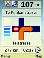
* Visual and voice guidance to any destination
* Search or define any location by its address
* Search and navigate to businesses listed in local search directories (where available)
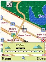
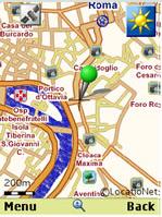
* Present any required location on the map
* View and use dynamic high quality maps at various scales
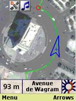
* View and navigate over high resolution satellite images
* Calculate the fastest way between two locations
* Save and manage personal favorites list
* Worldwide weather
amAze enables to calculate the route of a journey to any address or point of interest. Bluetooth connection with a GPS receiver will indicate your location along the route with vocal and graphical guidance to your destination in the shortest possible way. amAze is a collaborative effort led by LocatioNet Systems Ltd., together with some leading vendors in the fields of mapping, local search directories and other geographically related content.
Like it? Share with your friends!
Supported operating systems:
RIM BlackBerry OS 4.5, RIM BlackBerry OS 4.6, RIM BlackBerry OS 4.7, RIM BlackBerry OS 5.0, RIM BlackBerry OS 6.0
Similar Software:
Metro Maps Metro Maps- Find you way through complicated metro in major cities. The developer is currently giving away 3 metro city maps from major cities. I'm sure more maps will be available as his work progresses with the development of the software. The software works great with my blackberry, so far I was able to test out the New York Metro Map
Metro y Metrobus de México Metro y Metrobus de México - This application displays maps with zoom of the Metro, Metrobus, Mexibus, Suburban and Tren Ligero from Mexico City, Guadalajara y Monterrey In short it is an essential application for every inhabitant of the city
Sanoodi SMap GPS tracking Sanoodi SMap GPS tracking- NOW WITH IMPROVED TWITTER integration ! SMap GPS tracking app, share routes on Twitter and Sanoodi.com
Features:
- Two screens: a Pace Screen and a route Summary Screen
GEOrendr GEOrendr is a great way to discover and use maps. Maps come to life in GEOrendr. Tap on the map or use your current location and discover information about what you see. Find community hosted maps from ArcGIS Online - ESRI’s online GIS. Alternatively you can use the authoring tools on ArcGIS.com to create your own maps that can be used in GEOrendr
iCaller Location iCaller Location is a freeware application for Blackberry Smartphone. iCallerLocation shows the area code, city, and state of the incoming caller (United States only) and pinpoints the location on the Blackberry Maps. You will know where the call is coming from within the United States (will cover all cities in North America in the future)
World Wonders (BlackBerry) World Wonders (BlackBerry) - Finally, in one list, the world's "top" everything:
· The world's fastest...
· The world's tallest...
· The world's most expensive...
· The world's longest..
J2ME OGC WMS Client J2ME OGC WMS Client is a program for accessing OGC Web map services from Java enabled mobile phone or PDAs.
It accesses the OGC WMS according to WMS 1.1.0 and 1.1.1 specifications and supports zooming and panning in the Map, WMS sublayers, and a bookmark management system for quick access.
Free for non-commercial use
TopoExplorer for Touch Screen Devices ONLY TopoExplorer for Touch Screen Devices ONLY
Features | Free Download
With TopoExplorer you will discover your surroundings on topographic maps even in remote areas assisted by GPS and without the need of the wireless network connection
Other Software by developer «LocatioNet Systems Ltd.»:
amAze (Philips) First of its kind free navigation and local search service. It is free to download and use and it contains wide coverage of maps including aerial photo in Europe, North America, Australia and parts of Asia and Africa
amAze (LG) AmAze is a first of its kind free navigation and local search service. It is free to download and use and it contains wide coverage of maps including aerial photo in Europe, North America, Australia and parts of Asia and Africa
amAze (Samsung) AmAze is a first of its kind free navigation and local search service. It is free to download and use and it contains wide coverage of maps including aerial photo in Europe, North America, Australia and parts of Asia and Africa
amAze (Samsung) AmAze is a first of its kind free navigation and local search service. It is free to download and use and it contains wide coverage of maps including aerial photo in Europe, North America, Australia and parts of Asia and Africa
amAze (LG) AmAze is a first of its kind free navigation and local search service. It is free to download and use and it contains wide coverage of maps including aerial photo in Europe, North America, Australia and parts of Asia and Africa
amAze (Windows Mobile) AmAze is a first of its kind free navigation and local search service. It is free to download and use and it contains wide coverage of maps including aerial photo in Europe, North America, Australia and parts of Asia and Africa
amAze (Android) AmAze is a first of its kind free navigation and local search service. It is free to download and use and it contains wide coverage of maps including aerial photo in Europe, North America, Australia and parts of Asia and Africa
amAze (FLY) First of its kind free navigation and local search service. It is free to download and use and it contains wide coverage of maps including aerial photo in Europe, North America, Australia and parts of Asia and Africa
amAze (Sanyo) First of its kind free navigation and local search service. It is free to download and use and it contains wide coverage of maps including aerial photo in Europe, North America, Australia and parts of Asia and Africa
amAze (Motorola) AmAze is a first of its kind free navigation and local search service. It is free to download and use and it contains wide coverage of maps including aerial photo in Europe, North America, Australia and parts of Asia and Africa

")
")


")


")
")
")
")
")
")
")
")
")
")