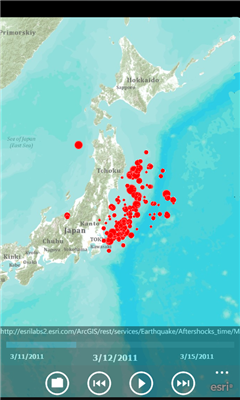
AGMapTime is a simple viewer with time slider features for "time-aware" layer data of ArcGIS services. Time slider lets you browse map features on specific time. You can view various kind of map layers from ArcGIS.com or your own ArcGIS server.
version 0.5 (First version)
- Only supports dynamic layer.
- Fixed base map.
- Slider auto detect time duration.
- Slider tick is roughly defined according to the duration. So the tick sometimes not equal to map's tick.
Like it? Share with your friends!
If you got an error while installing Themes, Software or Games, please, read FAQ.
Supported operating systems:
Windows 10 Mobile, Windows Phone 7, Windows Phone 8
Similar Software:
MapStalt Mini MapStalt Mini is an application that is meant to bring the map to completeness. In the case of the open street map, many details are missing, and MapStalt puts to power to complete the map into the hands of the mobile user. With MapStalt, a user can add something as simple as a building address and latitude/longitude or complex details such as business hours of operation
LR Maps LR Maps - This program is the Chinese version of the map program, the layer provided by the Google.Search functions are provided by Google Api and Baidu Api. Main functions are as follows: (1) through the GPS to locate and display the current location (2) Road name search with Chinese input: You can search for example, "Huaihai Road"
Mr.Map Mr.Map help users to find any place on the world using world map
Maps+ Maps+ - Maps Plus (Maps+) is an easy to use, powerful way to find directions, points of interest, locations, and anything else you're looking for
Pocket World Free Pocket World Free is your ultimate pocket guide for over 240 countries around the world. The app that puts the whole world on your fingertips. This free version is full featured, supported by ads
Puget Sound Traffic Puget Sound Traffic is a simple and quick way to view traffic conditions in the Puget Sound area.
Maps are fetched from the Washington State Department of Transportation as well as other sites for Seattle, Bellevue, Tacoma, Olympia, Bellingham and the US/Canada border. Recent incidents from the WSDOT area also displayed.
Maps are not interactive
SketchMaps Free! SketchMaps Free! - SketchMaps is the very first drawable live map which can also be saved to pictures. It's an unique idea and it's first of its kind. It's that simple. Please, view screenshots!
SketchMaps Free is full-featured, but will show ads. You can buy the full version of SketchMaps at any time to remove the ads
Prague Maps Prague Maps - This app contains offline (no data plan/reception necessary) public transportation maps for the Prague area, including tourist maps, metro/tram maps, and the Airport Express, which takes you from Prague Airport to popular the main train station, Hlavni Nadrazi
Other Software by developer «Denso IT Laboratory, Inc.»:
not found
Comments on AGMapTime:
Comments not found
If you noted an error or download link is broken, please, report it via this page or use comments.
AGMapTime is compatible with your device Blu W410i Win Jr