GPS Status & Toolbox - Be a GEEK: Get the most out of your phone. Raw GPS data at your fingertips.
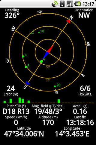
Display your GPS and sensor data: position and signal strength of satellites, accuracy, speed, acceleration, bearing.
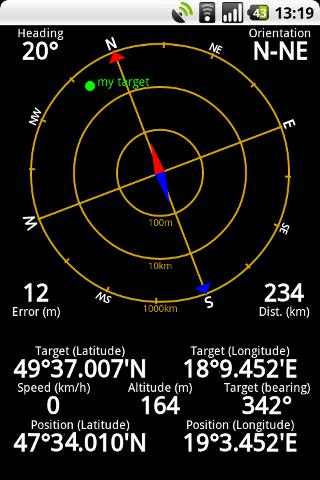
Tools included: compass with magnetic and true north, leveling tool, mark or share your location and navigate back later.
Keep your GPS fast: reset it or download A-GPS data regularly for faster fixes.
What's New in This Release:
· Workaround for Nexus S issues.
· aGPS age is correctly displayed (in hours / days).
· Fixed a rounding error in location formatting.
· More instruments for Nexus 7.
· Enhanced landscape layout. All instruments are available in landscape mode, too!
Like it? Share with your friends!
Supported operating systems:
Google Android 1.0, Google Android 1.5, Google Android 1.6, Google Android 10.x, Google Android 2.0, Google Android 2.1, Google Android 2.2, Google Android 2.3, Google Android 3.0, Google Android 3.1, Google Android 3.2, Google Android 4.0, Google Android 4.1, Google Android 4.2, Google Android 4.3, Google Android 4.4, Google Android 5.x, Google Android 6.x, Google Android 7.x, Google Android 8.x, Google Android 9.x
Similar Software:
JustCompass JustCompass - A simple compass app for Android with exact heading indicator.
What's New in This Release:
· Smoother compass animation
· Added address fetching
What's New in 0
Modern Compass Modern Compass this compass does what the compass always was intended to do, it helps you locate the destination of your choice.
Using GPS technology and Google maps, this application lets you mark a destination of choice and then shows in what direction that destination lies, as well as how far away it is from your current location
Altimeter Altimeter - Check your altitude wherever you are with Altimeter. The app uses GPS to find your altitude. You can also check your location using google maps
eGPS Elevation EGPS Elevation has greatly improved altitude and elevation readings. In a typical Android GPS, altitude readings are notoriously inaccurate. eGPS Elevation will even show how deep is the nearest water area
MUUDS MUUDS - Our Patented, color-coded, UV resistant PVC MUUDS Markers are a new and unique way to mark the exact depth of underground utilities. They are excellent way to prevent future excavation disasters
myAltitude See your Altitude, Min and Max Altitudes, Oxygen level and more! Wear Supported!
Talking Compass Talking Compass speaks your current heading and provides haptic feedback as your cross over any of the cardinal directions.
Touch the screen to hear your heading. Stroke the screen up/down to adjust verbosity
Ruler (Android) A simple application to turn your Android phone into an emergency measuring device
Hungarian for AnySoft Keyboard Kenyelmesen, magyarul irhat az Anysoft Keyboard segitsegevel. Magyar billentyűzet kiosztas es szotar AnySoftKeyboard-hoz. FIGYELEM! Ez egy kiegeszitő, ami csak az eredeti programmal egyutt műkodik. Onalloan nem!


")
