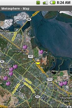
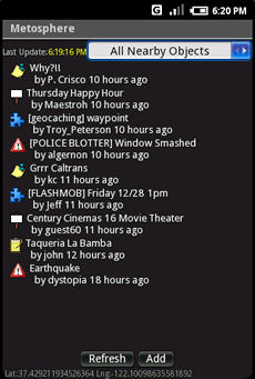
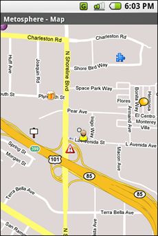
Metosphere Explore and create virtual objects around your physical location like messages, emergency alerts, events, news, reviews, games. View geospatial data from Wikipedia, Eventful, and Upcoming. Start a GeoBlog on your GPS-enabled phone.
This is the core Metosphere Android app. The goal is to follow the Firefox/Eclipse model and provide the ability to create extensions and add-ons like a Geocaching Assistant, Location Messaging Client, Proximity-based KML/GeoRSS Reader, Flash Mob Communicator, Community/Campus Emergency Alert Notifier, or even a Meatspace MUD game.
Like it? Share with your friends!
Supported operating systems:
Google Android 1.0, Google Android 1.5, Google Android 1.6, Google Android 10.x, Google Android 2.0, Google Android 2.1, Google Android 2.2, Google Android 2.3, Google Android 3.0, Google Android 3.1, Google Android 3.2, Google Android 4.0, Google Android 4.1, Google Android 4.2, Google Android 4.3, Google Android 4.4, Google Android 5.x, Google Android 6.x, Google Android 7.x, Google Android 8.x, Google Android 9.x
Similar Software:
My place My place This application allows you to determine your current location and to share it with your friends by sms or e-mail, if you want or need this.
Also it is possible to share your location with other apps, which are already installed on your phone (Google maps, Twitter apps, notes, etc.)
GPS Signal Widget GPS Signal Widget - Do you get tired waiting for the GPS location to be available? With this tool you can check out the GPS satellites and the signal strength in just a nice 1X1 widget.
The spokes in the widget represents the satellites and the length of the spokes is a measure of the signal strength.
Enable or disable the widget by tapping on the widget
GPSbySMS (Android) GPSbySMS is an application that reads navigation data from GPS and sends it to any user via SMS or email.
Purpose:
1) Read navigation data from GPS and send it to any user via SMS or email.
2) View current position on Maps (need Internet connection).
3) Save navigation data in database using data transfer via GPRS Internet.
4) Alarm Function
amAze (LG) AmAze is a first of its kind free navigation and local search service. It is free to download and use and it contains wide coverage of maps including aerial photo in Europe, North America, Australia and parts of Asia and Africa
wheredroid wheredroid is a simple application to display your coordinates from the GPS receiver: latitude, longitude, heading, speed, number of satellites used and (it's its peculiarity) altitude and accuracy. It is quite usable as an altimeter and a compass.
What's New in This Release:
· fixes a bug inverting East with West on some displays
What's New in 1.4
Speedometer GPS Speedometer GPS - Speedometer GPS can track your speed,distance,time,location and also can get start time,time elapased,avg speed,max speed,altitude...
Features included
- Save your track info,Record gpx file(it will be saved in "sdcard/SpeedometerGPS/gpx/")..
- Switch between car speedometer and bike cyclometer.
- Switch between mph or km/h mode
Zeen - Building Road Awareness Zeen, building road awareness together! Zeen is a fully featured, community driven mapping solution. - Over 500,000 data points at launch! Will continue to build thanks to the community! - Police Locations - Red Light Camera Locations - Speed Camera Locations - Traffic Reports / Locations
Ship Finder for Android Ship Finder for Android - Ship Finder is a useful application that allows you to track ships in near real-time on a 2D map.
Tap on a ship to view its name, port of registration, destination, ETA, location, MMSI, IMO, callsign , heading, length, width, draft, etc.
The app works by picking up AIS feeds used by the ships for safety and navigation purposes
GPS Odometer GPS Odometer - A simple and easy to use odometer. There is no maze of menus and no mysterious settings. GPS Odometer only does one thing, and does it well: measure distance traveled.
Note: Intended to measure relatively short distances, the application does not run in the background
YGPS Satellites YGPS Satellites - YGPS Satellites is a small mobile application that allows you to easily assess the quality of your GPS signal. The utility displays the location of all the GPS satellites and shows the signal strength for every one of them.
Using the app is pretty straightforward
Other Software by developer «metosphere.com»:
not found
Comments on Metosphere (Android):
Comments not found
If you noted an error or download link is broken, please, report it via this page or use comments.
Metosphere (Android) is compatible with your device Bluboo S8 Dual SIM LTE


")
")


")
")


