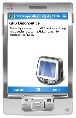
GPS Diagnostics 1.0 - These are the problems which users typically face when they're trying to get their GPS device to work:
1. Users' Windows Mobile 5.0+ devices frequently have incorrect GPS Intermediate Driver settings.
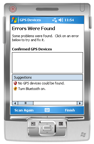
2. Users are unaware that Bluetooth is turned off, or do not know how to configure a virtual serial port for their GPS device.
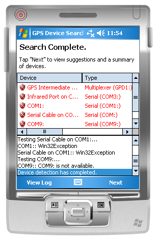
Built using GPS.NET 3.0, the utility will scan the local machine for GPS devices then make suggestions on what could be improved. Suggestions are in clear English and can be clicked to attempt a fix. This utility can:
1. Configure the GPS Intermediate Driver to correct COM: port and baud rate settings.
2. Detect when Microsoft Bluetooth is installed but turned off.
3. Suggest ideal COM: port and baud rate settings to use.
4. Recommend one device as "most reliable" when multiple devices are detected.
5. Generate log files which can (with some tweaking of code) be sent to you for further study.
Like it? Share with your friends!
If you got an error while installing Themes, Software or Games, please, read FAQ.
Supported operating systems:
Windows Mobile 2003, Windows Mobile 5.0, Windows Mobile 6 Classic, Windows Mobile 6 Professional, Windows Mobile 6.1 Classic, Windows Mobile 6.1 Professional, Windows Mobile 6.5 Professional
Similar Software:
ShoppingGoogler ShoppingGoogler uses the GPS on your PocketPC to find the 50 closest local stores sorted via GPS distance. Tap the button to start the GPS and when you get a lock tap on it to view the list of local stores. You can also dial the store phone number. The GPS maps and business search service is provided by Google
ReliRescue GPS ReliRescue ("Reli Search & Rescue") enables your Windows Mobile Phone to broadcast your location to designated partners (over SMS or email). Your location is obtained using Integrated or external (Bluetooth) GPS connected to your device.
This utility also enables any Windows Mobile platform to feed the broadcasted waypoints to track and locate the sender
FON Access Points for Sweden FON Access Points for Sweden - FON offers you a new Points of Interest service (POIs). This allows you to download FONspots directly to your navigation device.
What does that mean? You can download a Points of Interest file directly to your navigation device
FON Access Points for Uruguai FON Access Points for Uruguai - FON offers you a new Points of Interest service (POIs). This allows you to download FONspots directly to your navigation device.
What does that mean? You can download a Points of Interest file directly to your navigation device
gpsVP gpsVP works on virtually any Windows platform including mobile ones. It shows vector and raster maps, records and shows tracks, shows multiple navigation parameters, manages and shows waypoints. It aims to be as usable as possible.
What's New in This Release:
· Geoid correction matrix: Updated values Atlantic & east America's
ExerciseGPSes ExerciseGPSes - ExerciseGPSes uses the GPS on your PocketPC to graphically display your walking/running/riding speed on a moving graph. You can use this to keep your exercise pace. NOTE: The program does not display/graph 0 speeds.
This program requires that you have both the 'BeanDLL.dll' file ** and ** the runtime files for Visual Basic on your PocketPC computer
FilesGPSs FilesGPSs - FilesGPSs allows you to browse the GPS Picture/Video/Voice/Text etc. tagged files that are on your PocketPC. You can create and download a Google.com map of the folder or view each file on Google.com maps.
This program requires that you have both the 'BeanDLL.dll' file ** and ** the runtime files for Visual Basic on your PocketPC computer
BikeTrack BikeTrack - This application enables everybody (who got your user/pass) look up your location on the net, using your the page http://fiets.galway.nl/ and keeps track of you.
On the webpage you can also create a username so you can use the software.
What it does:
- Gets location from GPS.
- Sends it to BikeTrack Server
PictureGPSings PictureGPSings - PictureGPSings can be used when you want to describe a set of pictures/videos from your camera and GPS information. Enter the text to place at the end of the images and the text will appended to the end of the images/videos taken with the GPS information.
This program requires that you have both the 'BeanDLL
Other Software by developer «Jon Person»:
GeoFramework GeoFramework - This project was formerly a commercial library maintained by the company "GeoFrameworks" for two components it sold (GPS.NET and GIS.NET) from 2004 to 2009. In 2009, Jon Person decided to release the source code for this library in order to assist the open source community
GPS.NET GPS.NET is a formerly commercial .NET component maintained by GeoFrameworks, LLC from 2004 to 2009. In 2009, Jon Person decided to release the full source code of GPS.NET to the public domain for the benefit of the open source development community. This version (3.0) is the latest release