Rough Guides Map London... These guides are a series of fantastic interactive maps.
Produced in conjunction with the premier travel publisher Rough Guides.
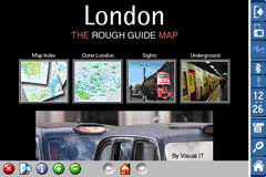
Discover and explore London using full colour interactive linked maps, in this simple to use PDA version of The Rough Guides London.
Find all the top tourist spots and key attractions with ease, information on the city and its sights can be quickly displayed with links to photographs and map locations. All in a superb easy to use interface.
If you''re travelling to London, be sure you don''t leave home without this guide on your PDA.
The Rough Guide city maps includes:
Fully scrollable and interactive maps of the city.
Tap any location to display information and available links.
Intuitive navigation bar meaning you are never more than one click away from the information you require.
Map links allow you to directly link to other maps, photographs, or detailed views.
Categorised Find feature allowing you to quickly find any street, place of interest or station.
Categorised Information feature providing a wealth of information on the city, places of interest, etc.
1-Click Home feature, keeping the Home map always at hand.
Zoom function on all maps.
Special Offer Only $20.00
Hi Res & landscape displays supported.
Like it? Share with your friends!
If you got an error while installing Themes, Software or Games, please, read FAQ.
Supported operating systems:
Pocket PC 2002, Windows Mobile 2003, Windows Mobile 5.0, Windows Mobile 6 Classic, Windows Mobile 6 Professional, Windows Mobile 6.1 Classic, Windows Mobile 6.1 Professional, Windows Mobile 6.5 Professional
Similar Software:
Google Maps Mobile Google Maps Mobile - Cruising around looking for a nearby coffee shop? Driving to that new restaurant but can't remember which street to turn right on? Now you can get business locations, maps and directions while you're on the go. And it's all free.
Real-time traffic
See where the congestion is, and estimate delays in over 30 major US metropolitan areas
TerraTrack Recorder 7 Route guidance in 3D view, makes navigation processes very simple and intuitive
Mobile Notes "Where I've been?" feature
Record track lines, points of interest(POI).
Different colors indicate different speed route.
Record text, picture and video style POI.
Record raw gps nmea data for reference and analysis.
Attach pictures to tags of geographical information
LiteTrack LiteTrack is the right tool to record your route, save off-road paths, retrace a way, get your position on the map with detailed gps data (satellite charts, speed and much more)
PDFJPGMaps PDFJPGMaps - PDFJPGMaps allows you to download a Google.com map of your current GPS and convert to PDF file format. You can draw on the map and also insert text into the maps as well as use the drawing tools. The JPEG libraries are from Independent JPEG Group. The map service is provided by Google.com. The PDF libraries are from JPEG2PDF by Hao Hu 2008
amAze (Motorola) AmAze is a first of its kind free navigation and local search service. It is free to download and use and it contains wide coverage of maps including aerial photo in Europe, North America, Australia and parts of Asia and Africa
PDA TileManager With PDA TileManager you can batch download OpenStreetMap maptiles.
Features:
Runs on Windows Mobile Devices with .NET CF 2.0 or above.
Read GPX track with trackpoints and waypoints
Direct support for Run
Rough Guides Map Madrid Rough Guides Map Madrid... These guides are a series of fantastic interactive maps.
Produced in conjunction with the premier travel publisher Rough Guides.
Discover and explore Madrid using full colour interactive linked maps, in this simple to use PDA version of The Rough Guides Madrid
zhiing - LBS for Everyone zhiing is a location messaging tool that allows you to share your location, or other locations of interest, with your friends, family or co-workers. Even update your location on your favorite social network! Forget about map printouts or scribbling down directions....just zhiing the location! Simply enter the mobile number or email you want to zhiing, and press send
Other Software by developer «Visual IT»:
Tube Melbourne (Series 60) Tube Melbourne (Series 60) - Our highly acclaimed Tube application that guides you around the metro and rail system of Melbourne is now available for your Series 60 Symbian powered phone. An essential addition to your phone for locals and tourists alike.
· A detailed clear colour map of the Melbourne metro & rail system fully scrollable
Beijing Subway for iPad by Zuti Beijing Subway for iPad by Zuti - Beijing Metro map makes it easy to travel in and around the city using the Beijing metro system and also includes the S2 rail line to the Great Wall at Badaling
Tube Madrid (Series 60) Tube Madrid (Series 60) - Our highly acclaimed Tube application that guides you around the complex metro system of Madrid is now available for your Series 60 Symbian powered phone. An essential addition to your phone for locals and tourists alike.
· A detailed clear colour map of the Madrid metro system fully scrollable.
· Quick find station utility
Beijing Subway by Zuti Beijing Subway by Zuti - The new Beijing Metro 10 map makes it easy to travel in and around the city using the Metro, Batong line, Airport Express line and Suburban S2 lines services
Zoom Zoom - Do you sometimes struggle with the small text and graphics on your display?, then Zoom is the tool for you.
This small utility lets you instantly see a high quality bi-cubic zoomed area of any part of the display
Tube 2 Baltimore (Palm OS) Tube 2 Baltimore (Palm OS) - This map package for Tube 2 consists of a fully scrollable detailed map of the Baltimore metro & rail system.
Plan journeys on this system, list details of the quickest routes and see a superb animated display of your journey tracking around the system map
Tube 2 Chicago (Palm OS) Tube 2 Chicago (Palm OS) - This map package for Tube 2 consists of a fully scrollable detailed map of the Chicago metro & commuter rail system.
It includes the rapid transport system of subway and elevated lines, in addition to the many commuter rail lines. The map also indicates how the Amtrak intercity routes intersect with the cities transport network
Tube 2 Barcelona (Palm OS) Tube 2 Barcelona (Palm OS) - This map package for Tube 2 consists of a fully scrollable detailed map of the Barcelona metro & rail system.
Plan journeys on the metro system, list details of the quickest routes and see a superb animated display of your journey tracking around the system map
Tube 2 Madrid Pro (UIQ3) Tube 2 Madrid Pro (UIQ3) - This map package for Tube 2 consists of a fully scrollable detailed map of the Madrid metro system and linked street maps of central Madrid.
Plan journeys on the metro system, list details of the quickest routes and see a superb animated display of your journey tracking around the system map
Tube 2 New York City (UIQ3) Tube 2 New York City (UIQ3) - This map package for Tube 2 consists of a fully scrollable detailed map of the New York City MTA subway system.
Plan journeys on this system, list details of the quickest routes and see a superb animated display of your journey tracking around the system map


 Hi Res & landscape displays supported.


")


")

")


")
")
")
")
")