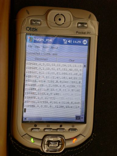
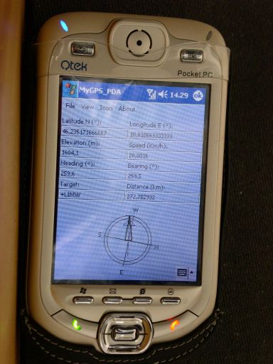
MyGPS_PDA - MyGPS_PDA is a light MyGPS version for PocketPC systems. It reads the NMEA sentences coming from a GPS antenna connected to the PocketPC and shows your position on a MyGPS calibrated map. The program can also store on a file the track log together with specific waypoints created by the user.
Like it? Share with your friends!
If you got an error while installing Themes, Software or Games, please, read FAQ.
Supported operating systems:
Windows Mobile 2003, Windows Mobile 5.0, Windows Mobile 6 Classic, Windows Mobile 6 Professional, Windows Mobile 6.1 Classic, Windows Mobile 6.1 Professional, Windows Mobile 6.5 Professional
Similar Software:
MapFingerer MapFingerer - MapFingerer allows you use the GPS on your device or custom GPS values to download maps from Google.com and keeps them in a finger friendly database. You can make multiple pages for the maps. Tap on the map to button to view it.
This program requires that you have both the 'BeanDLL
FON Access Points for United Arab Emirates FON Access Points for United Arab Emirates - FON offers you a new Points of Interest service (POIs). This allows you to download FONspots directly to your navigation device.
What does that mean? You can download a Points of Interest file directly to your navigation device
RulerGPS RulerGPS - This program allows you to calculate the distance in Miles, Feet, Inches, KM, Meters and CM based on two latitude and longitude points. This can be used as a ruler for construction etc. with GPS.
This program requires that you have both the 'BeanDLL.dll' file ** and ** the runtime files for Visual Basic on your PocketPC computer
TaxiGPSer TaxiGPSer - TaxiGPSer uses the GPS on your PocketPC to find your current latitude/longitude/speed and allows you to send it to a preset Taxi or shuttle service via email. Tap the button to get the GPS lock and when the program gets the lock it will send the email.
This program requires that you have both the 'BeanDLL
GeoFence MASPware GeoFence is a GPS-based surveillance tool for Windows Mobile devices. This program loads a virtual fence (GPX/KML) and starts alerts, if the current position is out of bounds.
This program can use any kind of GPX (GPS Exchange Format) data files and can also use Google KML files. You can easily record tracks with e.g
ExcelGPSs ExcelGPSs - ExcelGPSs can be used to make Excel sheets with a GPS tag as the sheet file name. Each time you make a sheet the sheet is named the latitude and longitude of the file. You can store your files on the storage card. You can also view the Excels with Google maps.
This program requires that you have both the 'BeanDLL
PictureGPSings PictureGPSings - PictureGPSings can be used when you want to describe a set of pictures/videos from your camera and GPS information. Enter the text to place at the end of the images and the text will appended to the end of the images/videos taken with the GPS information.
This program requires that you have both the 'BeanDLL
Locify With Locify you can explore interesting places near you from Wikipedia, seek for geocaches, display map where you are (or you want to go), twitter your location, save interesting places from phone or web sync them and even navigate to them... and much more.
Locify is free application for common mobile phone
BankGoogler BankGoogler uses the GPS on your PocketPC to find the 50 closest banks (ATMs) sorted via GPS distance. Tap the button to start the GPS and when you get a lock tap on it to view the list of local banks. You can also dial the bank. The GPS maps and bank search service is provided by Google
RulerZIPer RulerZIPer allows you to find the distance from your current GPS to a US ZIP code. Start the GPS and when you get a GPS lock then enter the ZIP code. The program converts the ZIP code to GPS coordinates and displays the distance. This service is provided by USZIP
Other Software by developer «Paolo Faure Ragani, Pier Paolo Colombo»:
not found
Comments on MyGPS_PDA:
Comments not found
If you noted an error or download link is broken, please, report it via this page or use comments.
MyGPS_PDA is compatible with your device Bluebird Pidion BIP-6000