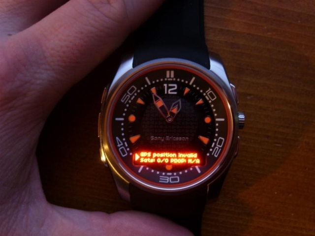
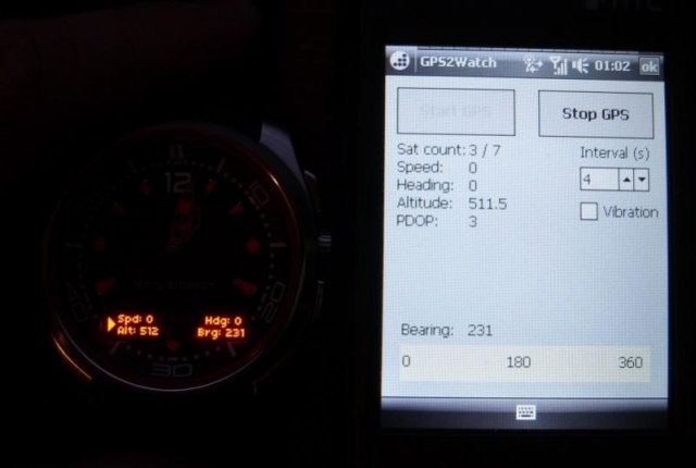
GPS2Watch - Add-on for smartWatchM that displays GPS information on supported Bluetooth watches. It simply uses smartWatchM "3rd party notifications", and connects to WM5+'s intermediate GPS driver, so no messing with COM ports. It should work with any device/GPS combination, if the GPS is external it must be set in WM's "External GPS" settings. Simply run the program, click "Start GPS", and the watch should start displaying GPS info, refreshed every 4 seconds (this seems to be the best choice to have a nearly continuous display, seeing how smartWatchM polls the text file). This results in only short blinks from the watch between screen updates.
The watch will display "GPS Position Invalid" when used sats < 3 or PDOP > 10. In normal display, the display shows Speed, alt, heading and a user settable bearing.
· GPS speed, alt, heading display
· User settable bearing
· User-definable update rate, min 4 seconds
· Watch vibration on/off
· Uses WM5+ GPS driver, so make sure "External GPS" settings are correct (DON'T touch if you use an internal GPS)
Like it? Share with your friends!
If you got an error while installing Themes, Software or Games, please, read FAQ.
Supported operating systems:
Windows Mobile 5.0, Windows Mobile 6 Classic, Windows Mobile 6 Professional, Windows Mobile 6.1 Classic, Windows Mobile 6.1 Professional, Windows Mobile 6.5 Professional
Similar Software:
TwitterGPSes TwitterGPSes allows you to view the current GPS and status of your Twitter contacts. Enter the name of each contact to assign to a button. When you tap on the button the persons Twitter page will be downloaded and a Google.com map will display the location. This service is provided by Twitter
ExerciseGPSes ExerciseGPSes - ExerciseGPSes uses the GPS on your PocketPC to graphically display your walking/running/riding speed on a moving graph. You can use this to keep your exercise pace. NOTE: The program does not display/graph 0 speeds.
This program requires that you have both the 'BeanDLL.dll' file ** and ** the runtime files for Visual Basic on your PocketPC computer
MapGoogler MapGoogler uses the GPS on your PocketPC to find your current latitude/longitude/speed and altitude and allows you to view your position on a map from the Google.com maps service. You can customize the maps zoom, and type via the 'Options' in the toolbar. The maps service is provided by Google
gpsVP gpsVP works on virtually any Windows platform including mobile ones. It shows vector and raster maps, records and shows tracks, shows multiple navigation parameters, manages and shows waypoints. It aims to be as usable as possible.
What's New in This Release:
· Geoid correction matrix: Updated values Atlantic & east America's
FON Access Points for Tunisia FON Access Points for Tunisia - FON offers you a new Points of Interest service (POIs). This allows you to download FONspots directly to your navigation device.
What does that mean? You can download a Points of Interest file directly to your navigation device
TravelGPSes TravelGPSes uses the GPS on your PocketPC to find your current latitude/ longitude/ speed and altitude and looks up the Tixik.com GPS listings and displays them. Tap the button to start the GPS and when you get the lock tap the button again to view the Tixik.com listings for the area. This service is provided by Tixik
VITO SmartMap Pocket PC VITO SmartMap is GPS moving map for your smartphone.
It uses relatively small vector maps, which are perfect for driving or hiking with it. You can also use VITO SmartMap without maps for recording tracks to find your way back
ContactGPSer ContactGPSer allows you to create and view phone/SMS/email contact number '.cgps' links and Dial/SMS or Email the contacts via GPS distance. Select 'Start GPS' to get a GPS lock and create a new '.pgps' contact link. The program displays the distance between each contact via your current GPS
KidsGPSs KidsGPSs - KidsGPSs can be used to get an update of your kids' GPS location using the PocketPC KidsGPSer. The program downloads the GPS location for each child and stores it into the database. You can view a map of all your kids' current GPS locations on the Google.com maps.
This program requires that you have both the 'BeanDLL
SportyPal SportyPal is an easy to use intuitive application for your mobile device. You activate it when you start your running, cycling, walking, rollerblading or similar exercise. In two simple clicks it will start to log and map your position, movement, distance, tempo and calories burned
Other Software by developer «kilrah»:
not found
Comments on GPS2Watch:
Comments not found
If you noted an error or download link is broken, please, report it via this page or use comments.
GPS2Watch is compatible with your device Bluebird Pidion BM-150R GSM/CDMA