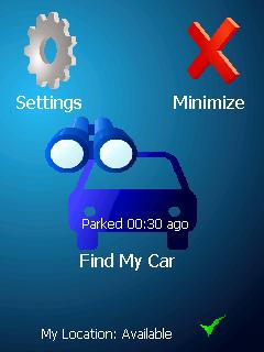
ppc FindMyCar - Innovative software for Windows Mobile devices that uses the GPS signal to show signs that allow to reach a geographic location.
Suitable for various uses (eg. find car parked in a parking area or in an unknown city, finding a person (who has sent their coordinates) in a lovely beach, in a fair, in another boat, find an area of sea fishing, etc..).
· store position and then retrieved at a later date
· forward our position with sms
· set the position transmitted (eg. the person we are looking for) with the copy-paste function
· displayed on the map (via internet GoogleMap) location to be searched
Like it? Share with your friends!
If you got an error while installing Themes, Software or Games, please, read FAQ.
Supported operating systems:
Windows Mobile 2003, Windows Mobile 5.0, Windows Mobile 6 Classic, Windows Mobile 6 Professional, Windows Mobile 6.1 Classic, Windows Mobile 6.1 Professional, Windows Mobile 6.5 Professional
Similar Software:
ExcelGPSer ExcelGPSer - ExcelGPSer allows you to make Pocket Excel files and attaches a GPS tag to the end of the file. You can also view the notes via GPS distance from your current GPS using "The Vincenty inverse formula for ellipsoids." (accuracy to within 0.5mm, or 0.000015")
This program requires that you have both the 'BeanDLL
Mobitee Lite Mobitee is a mobile application intended for both skilled and beginning golfers with the purpose to diversify the game and make it accessible simultaneously allowing to raise game level
RulerGPSer RulerGPSer - RulerGPSer uses the GPS on your PocketPC to view and download GPS marked satellite camera pictures and calculates distance between two points specified by the latitude/longitude of your GPS using "The Vincenty inverse formula for ellipsoids." (accuracy to within 0.5mm, or 0.000015")
This program requires that you have both the 'BeanDLL
iPlotter A comprehensive maritime passage planning and chart plotter navigation aid for Windows Mobile
FON Access Points for Taiwan FON Access Points for Taiwan - FON offers you a new Points of Interest service (POIs). This allows you to download FONspots directly to your navigation device.
What does that mean? You can download a Points of Interest file directly to your navigation device
amAze (Sony Ericsson) AmAze is a first of its kind free navigation and local search service. It is free to download and use and it contains wide coverage of maps including aerial photo in Europe, North America, Australia and parts of Asia and Africa
Wizi Wizi is a free instant location sharing service which let you send your location to a friend via SMS or E-mail. Use Wizi to tell a friend where you are now or where you are going to meet. It uses your integrated or external GPS unit to find your location and show it on the map. If you have other friends using Wizi you can always find them on the map
FON Access Points for Estonia FON Access Points for Estonia - FON offers you a new Points of Interest service (POIs). This allows you to download FONspots directly to your navigation device.
What does that mean? You can download a Points of Interest file directly to your navigation device
MapZIPeds MapZIPeds allows you to enter US ZIP code and gets your current GPS and downloads a Google.com map with a route of the ZIP code to your current GPS. Enter the ZIP code and start the GPS to get the lock. When you get the lock tap the button to view/download the map. This service is provided by USZIP
GPSMaperer GPSMaperer is a full featured map downloader. You can enter the lat/long coordinates or use your current GPS to download a map. You can download in GIF, PNG or JPEG format. The program has several options to customize the map. The map service is provided by Google
Calcola Taglie (Clothing Size) Calculate - size clothing and accessories. It allows the calculation of certain components of clothing. Easy to use. Fit the size head, life, neck and sides and you get the size calculated. For shoes, just insert the length of the foot longer and you get the size
j2me FindMyCar j2me FindMyCar - Innovative software for mobile devices that uses the GPS signal to show signs that allow to reach a geographic location.
Suitable for various uses (eg. find car parked in a parking area or in an unknown city, finding a person (who has sent their coordinates) in a lovely beach, in a fair, in another boat, find an area of sea fishing, etc..)
J2ME Marcatempo Record date, time and description of events. Export data to excel file or send them by email. The application is very useful for monitoring work activities
PhoneAlcolTest Calculate blood alcohol based on the tables attached to the DM 30/07/2008 THE MINISTRY OF LABOR, HEALTH AND SOCIAL POLICY bearing: "Urgent changes in the code of the street to increase safety levels in the circulation


")


")


