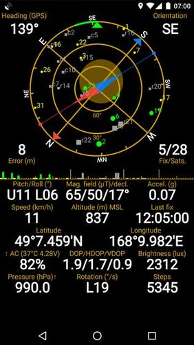
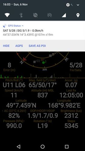
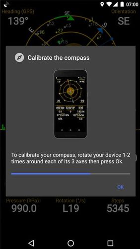
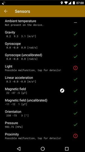
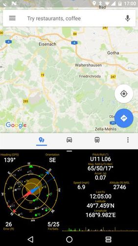
GPS status & toolbox - is a very useful program for working with GPS. This utility is aimed at viewing GPS condition and settings. It can display all data of a sensor and GPS: positions and satellite signal power, accuracy, speed, acceleration, height, step and even battery status.
Game features:
Magnet compass with accurate north
All data of a sensor and GPS
Fast search
Simple and comprehensive interface
Loading video...
Like it? Share with your friends!
Supported operating systems:
Google Android 4.1, Google Android 4.2, Google Android 4.3, Google Android 4.4, Google Android 5.x, Google Android 6.x, Google Android 7.x, Google Android 8.x
Similar Software:
iTrackMe (Android) iTrackMe (Android) is a Family GPS Tracker that allows parents to track loved ones using their phones. iTrackMe consists of a web portal (iTrackMe.net) that allows parents to see the location of their kids in real-time on a map and a small mobile application running on the kids' mobile phones. Parents can define safety zones (school, mall, etc
Mock locations - Fake GPS path Mock locations - is an application which will help you hide your location. With its help you can set 2 certain points and make your device move between these points.When you will view the covered distance on google maps, it will show you not the place you were for real
GoPenS GoPenS is an OpenSource GPS application for Android phones, based on OpenStreetMap (OSM). OpenStreetMap is a collaborative map of the world. Therefore, one of the main functions of the application is to be able to record a trace and send it as a GPX to the OSM servers, and so edit the OSM Map
GPS Map Camera use GoogleMap GPS Map Camera use GoogleMap - The main feature of the 'GPS Map Camera':
When you take a piture with GPS enabled, it will paste the google map, address and weather to picture. (GPS latitue/longitude also include in the information)
Please enable your network and GPS function before using this application
Wiot lite Wiot lite -is an application which will track your locations with the help of sattelite monitoring system. The application indicates your current GPS position and sends them to the server. You will always know where your close people are
GpsTicker Gpsticker is a program for outdoor orientation and navigation with GPS, it is best for hiking and biking. Maps are downloaded automatically from OpenStreetMaps, provided the Phone has an active internet connection
WeWhere - Find Friends WeWhere - Find Friends - This app is a program to check the location of your friends in real time.
** IPhone users can share with.
[How to]
1. Click "Request" in settings menu after logging in.
2. Send request after entering your friend's ID.
3. your request friend : "Accept" menu click and confirm
Digital Dashboard GPS Digital Dashboard GPS - Features included
- Save your track info,Record gpx file(it will be saved in "sdcard/DigitalDashboardGPS/gpx/")..
- Switch between car speedometer and bike cyclometer.
- Switch between mph or km/h mode.
- Display satellites status.
- Speed chart.
- Map integration,get your location.
……
Facebook:https://www.facebook
amAze (Samsung) AmAze is a first of its kind free navigation and local search service. It is free to download and use and it contains wide coverage of maps including aerial photo in Europe, North America, Australia and parts of Asia and Africa
Maveric Maveric Systems is a leading provider of IT Lifecycle Assurance services across the technology adoption life cycle
Comments on GPS status & toolbox:
rob:
Nice
Date: 7 Nov 21
If you noted an error or download link is broken, please, report it via this page or use comments.
GPS status & toolbox is compatible with your device Caterpillar CAT B15


")


")
