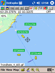
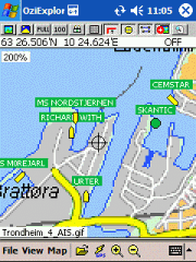
AIS2OZI - AIS2OZI tracks ship positions. It is a logger/decoder/plotter for PocketPC.
Ship positions are plotted directly in OziExplorer Download AIS2OZI (Make backup of Shiplist.txt when reinstalling.)
Decodes AIVDM sentences of types 1, 2, 3 and 5, i.e. position reports for class A shipborne equipment plus vessel information.
Like it? Share with your friends!
If you got an error while installing Themes, Software or Games, please, read FAQ.
Supported operating systems:
Windows Mobile 5.0, Windows Mobile 6 Classic, Windows Mobile 6 Professional, Windows Mobile 6.1 Classic, Windows Mobile 6.1 Professional, Windows Mobile 6.5 Professional
Similar Software:
GPSRulerer GPSRulerer uses GPS to find two points and uses the "The Vincenty inverse formula for ellipsoids." (accuracy to within 0.5mm, or 0.000015"). Select 'Start GPS' to start the GPS and when you get a lock you can view your current GPS. Tap the button to save it and measure your distance. The map service is provided by Google
G-Watch G-Watch is a stop watch which supports GPS devices. It keeps track of your distance, speed and altitude. G-Watch is a tool which combines following features: stopwatch, countdown timer and geocaching
CellGPSing CellGPSing uses the cellular signal on your device to instantly find your approximate GPS and display on a Google.com map. Tap the button while your phone is on and the program will send your cellular tower information to OpencCellID.org. The program will then display the approximate GPS. This service is provided by OpenCellID
TravelPicturer TravelPicturer - TravelPicturer uses the GPS on your PocketPC to graphically view your GPS movement. You can adjust the slider for to view larger distances on the map. This uses "The Vincenty inverse formula for ellipsoids." (accuracy to within 0.5mm, or 0.000015")
This program requires that you have both the 'BeanDLL
GpxView GpxView - For those who use their GPS for fun and who play Geocaching, this little unpretensious utility will allow them to manage their caches directly with the PLDA.
Thi sprogram is stricly documentative. There is no communication with the GPS. Information is retreived via Internet from the reference site Geocaching.com
PictureSharer PictureSharer - This program allows you to send/receive JPEG pictures via IRDA.
This program requires that you have both the 'BeanDLL.dll' file ** and ** the runtime files for Visual Basic on your PocketPC computer. Simply unzip the file for your processor and place the DLL file in the 'Windows' folder of your PocketPC computer. For free support on installing email me
FON Access Points for Turkey FON Access Points for Turkey - FON offers you a new Points of Interest service (POIs). This allows you to download FONspots directly to your navigation device.
What does that mean? You can download a Points of Interest file directly to your navigation device
SMSGPSer SMSGPSer allows you to create SMS contact number '.pgps' links and dial them via GPS distance. Select 'Start GPS' to get a GPS lock and create a new '.pgps' phone number. The program displays the distance between each GPS point and your current GPS. Tap on the link to start the built in SMS composer
OpenMobileMaps An application similar to Google Maps, but relying on OpenStreetMap
Other Software by developer «Frank Dahlslett»:
not found
Comments on AIS2OZI:
Comments not found
If you noted an error or download link is broken, please, report it via this page or use comments.
AIS2OZI is compatible with your device Cingular 8125