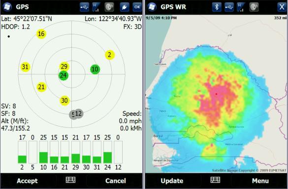
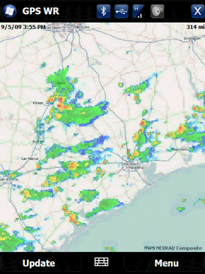
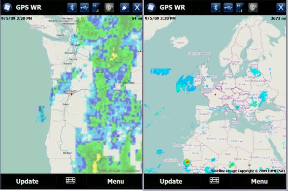
GPS Enabled Weather Radar is weather application that uses your built-in GPS to pull radar images from 3rd party weather services. You can view imaging in satellite or radar formats. It’s currently supported for North America, but it might be possible to add other locations with radar sites.
GPS Enabled Weather Radar Video Preview
GPS Enabled Weather Radar Features:
- Gets weather radar for current GPS location or using cell towers
- Ability to manually enter location
- Click anywhere on the map to move to that location
- Different views and zoom levels
- Animated radar loop
- Integrates with Showaco TitaniumWeather 4.2 PlugIn
New version 2.2.05
- Speed and stability improvements.
- Other minor fixes.
New version 2.2.02
- Added a version for WM Standard (non touchscreen).
- Other minor enhancements.
Like it? Share with your friends!
If you got an error while installing Themes, Software or Games, please, read FAQ.
Supported operating systems:
Windows Mobile 5.0 Smartphone, Windows Mobile 6 Standard, Windows Mobile 6.1 Standard, Windows Mobile 6.5 Standard
Similar Software:
GPS Test GPS Test - This software tests the connection between your GPS unit and your smartphone. It displays satellite signal and position information as well as your current position, speed and bearing. The software has a night mode for use in low light conditions
FON Access Points for Poland FON Access Points for Poland - FON offers you a new Points of Interest service (POIs). This allows you to download FONspots directly to your navigation device.
What does that mean? You can download a Points of Interest file directly to your navigation device
GPSed Smartphone Record GPS tracks from your mobile and trace them on a map.
Record tracks of your trips anywhere on the Earth from your mobile device. Tracks are traced on Google Maps and stored in an online archive. All you need to start tracking is a mobile device with the internal or external GPS receiver
ReliRescue GPS ReliRescue ("Reli Search & Rescue") enables your Windows Mobile Phone to broadcast your location to designated partners (over SMS or email). Your location is obtained using Integrated or external (Bluetooth) GPS connected to your device.
This utility also enables any Windows Mobile platform to feed the broadcasted waypoints to track and locate the sender
VITO SmartMap Smartphone VITO SmartMap for Smartphone is GPS moving map for your Smartphone.
It uses relatively small vector maps, which are perfect for driving or hiking with it. You can also use VITO SmartMap without maps for recording tracks to find your way back
VirtualGPS Pro VirtualGPS Pro is a small utility, which fully emulates GPS module and returns your location (by using cellular towers and/or wi-fi hotspots). Location accuracy is about 50-500m.
Other features
Does not consume power
Works in buildings
It's always inside of your PDA unlike the bluetooth GPS.
How To Use:
1
TerraTrack Recorder 7 Route guidance in 3D view, makes navigation processes very simple and intuitive
FON Access Points for Thailand FON Access Points for Thailand - FON offers you a new Points of Interest service (POIs). This allows you to download FONspots directly to your navigation device.
What does that mean? You can download a Points of Interest file directly to your navigation device
FON Access Points for Costa Rica FON Access Points for Costa Rica - FON offers you a new Points of Interest service (POIs). This allows you to download FONspots directly to your navigation device.
What does that mean? You can download a Points of Interest file directly to your navigation device
FON Access Points for Yemen FON Access Points for Yemen - FON offers you a new Points of Interest service (POIs). This allows you to download FONspots directly to your navigation device.
What does that mean? You can download a Points of Interest file directly to your navigation device
Comments on GPS Enabled Weather Radar:
Comments not found
If you noted an error or download link is broken, please, report it via this page or use comments.
GPS Enabled Weather Radar is compatible with your device Cingular Blackjack


.jpg)