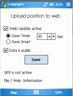
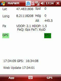
MapWM - Record GPS data with your Windows Mobile device.
What's New in This Release:
· Changed expiration date to Dec 31th 2012.
Like it? Share with your friends!
If you got an error while installing Themes, Software or Games, please, read FAQ.
Supported operating systems:
Pocket PC 2002, Windows Mobile 2003, Windows Mobile 5.0, Windows Mobile 6 Classic, Windows Mobile 6 Professional, Windows Mobile 6.1 Classic, Windows Mobile 6.1 Professional, Windows Mobile 6.5 Professional
Similar Software:
OakLogMobile OakLogMobile - Logger application for your Windows Mobile device. Records GPS and sensor information on your phone.
The log files (*.olg) can later be loaded into TrackView.NET and viewed in all their 3D-glory.
Just copy the .exe-file onto your device manually and run it via the file explorer.
· Logs GPS position, altitude, speed, etc
Glopus Glopus is a program for the Pocket PC that delivers information from a GPS receiver
GPSPicturer GPSPicture allows you to create GPS stamped JPEG files and displays them in an easy to use explorer interface. When you get a GPS lock the program will display the JPEG files in order of distance to your current GPS. To view the image file simply tap on it. The map service is provided by Google
AgMapper AgMapper - Create maps using your Windows Mobile device. Measure lengths and view areas without the desktop PC.
AgMapper makes it easy to map what ever you like and share it with other software packages by using the very common shape file format (.shp) to store your mapping data.
Load images onto your map created using the FREE AgMapper Image Converter
TaxiAddresser TaxiAddresser uses the GPS on your PocketPC to find your current latitude/ longitude/ speed/ altitude and Googles the Address/City and allows you to send it to a preset Taxi or shuttle service via email. Tap the button to get the GPS lock and when the program gets the lock it will send the email
GPS Tuner Essentials Full Version with Baltic Basic Map Content GPS Tuner Essentials Full Version with Baltic Basic Map Content - is designed specifically for off-road use: its large buttons, selectable tool window size, multiple Compass views and the built-in Tele Atlas map makes it extremely user-friendly and reliable
FON Access Points for Bangladesh FON Access Points for Bangladesh - FON offers you a new Points of Interest service (POIs). This allows you to download FONspots directly to your navigation device.
What does that mean? You can download a Points of Interest file directly to your navigation device
Woodpecker GeoScout GeoScout is designed to be the only software you need to go geocaching. You can download/import, view and manage all caches of interest. With a connection to a suitable GPS, GeoScout can also guide you to the cache waypoint(s).
GeoScout requires individual gpx files for each cache, however don''t worry if you don''t have these
GPSToday GPSToday-GeoTerrestrial GPSToday now brings an unbeatable combination of location features to your mobile device.
Driving/Walking directions in many countries, with traffic-optimization option.
Log file plotting on map and animated "playback". Also, the geologger will now never clip corners, and will perfectly follow loopy highway ramps
Other Software by developer «Stefan Seiz»:
SMSExporter SMSExporter - Microsoft left out an important feature in Windows Mobile: The ability to store text messages permanently. On the mobile phone, they are kept in a folderish structure, but there is no way to export that information to a file. SMSExporter is here to change that. Store read / unread and or Sent / Received text messages to a file