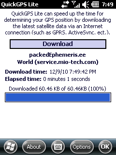
QuickGPS Lite can speed up the time for determining your GPS position by downloading the latest satellite data via an Internet connection (such as GPRS, ActiveSync, etc.).
For quickest connection use:
1. Mod Driver
2. QuickGPS Lite
3. GPS Test
It takes around 10 seconds from cold start to get 9 satellites and have a stable connection.
What's New in This Release:
· Illegal characters in path error, added packedEphemeris server
Like it? Share with your friends!
If you got an error while installing Themes, Software or Games, please, read FAQ.
Supported operating systems:
Windows Mobile 2003, Windows Mobile 5.0, Windows Mobile 6 Classic, Windows Mobile 6 Professional, Windows Mobile 6.1 Classic, Windows Mobile 6.1 Professional, Windows Mobile 6.5 Professional
Similar Software:
TwitterGPSes TwitterGPSes allows you to view the current GPS and status of your Twitter contacts. Enter the name of each contact to assign to a button. When you tap on the button the persons Twitter page will be downloaded and a Google.com map will display the location. This service is provided by Twitter
trackr! Use trackr! to let people know where you are and where you have been. All you need is the Internet, a GPS receiver and your mobile phone (or a mobile phone with an internal GPS receiver)
FON Access Points for Thailand FON Access Points for Thailand - FON offers you a new Points of Interest service (POIs). This allows you to download FONspots directly to your navigation device.
What does that mean? You can download a Points of Interest file directly to your navigation device
ppc PhotoGeoTag ppc PhotoGeoTag - Take pictures with your mobile phone and incorporate the data of the geographical location. The application allows you to include in the photographs, data from the GPS receiver, along with a brief note. If you know the coordinates, not having the GPS receiver, you can also handwrite geographic data
GPS Tuner Essentials Full Version with Baltic Basic Map Content GPS Tuner Essentials Full Version with Baltic Basic Map Content - is designed specifically for off-road use: its large buttons, selectable tool window size, multiple Compass views and the built-in Tele Atlas map makes it extremely user-friendly and reliable
WMMiniGPS WMMiniGPS is a Windows Mobile 5/6 software which gets your GPS data in a really simple gui, showing you latitude, longitude, altitude and speed. It can log all to file and it can export your paths to Google Earth's kml and gpx format
TravelGPSer TravelGPSer - TravelGPSer uses the GPS on your PocketPC to graphically view your GPS movement. You can adjust the slider for to view larger distances on the map. This uses "The Vincenty inverse formula for ellipsoids" (accuracy to within 0.5mm, or 0.000015").
This program requires that you have both the 'BeanDLL
TimeGPSs TimeGPSs - This program allows you to enter two sets of GPS points and a speed reading in Miles or KM/H. Then the program displays the distance between the two points and the amount of time to travel from each point.
This program requires that you have both the 'BeanDLL.dll' file ** and ** the runtime files for Visual Basic on your PocketPC computer
e-Mobile GPS Tracker e-Mobile GPS Tracker -
System Requirements
Internet enabled Windows mobile Pocket PC with GPS.
Requires WM5 and WM6 mobile devices