PrettyMap Basic - View maps of Earth and other planets with PrettyMap! See current day and night areas, learn geography with the quiz, enjoy 3D elevation surfaces, measure distances between locations and create your own maps with special places! PrettyMap lets you view vector and raster maps and images (such as country boundaries, world cities, rivers, satellite photos), search in geographically-referenced data, visualize and analyze spatial information, extend your knowledge, and edit your own simple maps. PrettyMap is a GIS program with the following features:
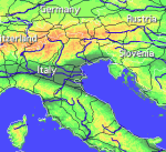
support for vector maps (points, lines, areas)
support for raster maps (terrain elevation and bathymetry, images, symbolic)
handles multi-attribute data associated with vector map objects
displays maps of various planets
free maps available:
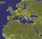
country boundaries with country names, capitals, population sizes, ...
major cities with names, status, population ranks and classes, ...
USA states with areas, population sizes, males, females, age, marriage, race, and household statistics, ...
major rivers
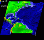
elevation data for Earth, Moon, Mars
and many more!
internet connection not required on your PDA
various color schemes for elevation maps
user-defined elevation colors
zoom range from whole planet to meters
shows day and night area, computes shadow length and sun/north orientation
multiple, configurable vector map layers
data search for vector map databases
versatile quiz with teacher mode for vector map databases
bar charts and color-by option for numeric features in vector map databases
relief and 3D elevation (DEM) view with vector map overlay
distance measurement
integrated user-defined locations (Points Of Interest) editor, stores notes and values for each POI
sessions to quickly save/restore program state
adjustable water level for elevation data
numerous settings to customize the program
Try before you buy! PrettyMap is a shareware with a 30-day evaluation period, then you have to register.
Registered PrettyMap Basic has the following limitations:
the quiz is limited to 20 questions
user locations editor is limited to 20 points per map; one user map open at a time
inactive "containing" option in vector data search.
· 30 days trial
· the quiz is limited to 20 questions
· no spheral elevation relief view
· no online weather reports and forecasts for user-defined locations
· user locations editor is limited to 20 points per map; one user map open at a time
· inactive "containing" option in vector data search
What's New in This Release:
· slightly faster displaying of vector maps
· fixed drawing of some vector maps: objects are now again sorted by importance (this was a bug since v5.3)
· improved default color styles for labels on vector area maps
· usability enhancements
Like it? Share with your friends!
Supported operating systems:
Palm OS 5.x
Similar Software:
Go2TT Go2TT- allows you to select an address from within the Contacts application found on newer Palm devices (T3, T5, TX, LifeDrive, ...) and starts TomTom Navigation 5, guiding you to the selected address, or showing it on the map
Travel Florence (Palm OS) Travel Florence (Palm OS) - illustrated city guide, phrasebook, and maps. Indulge Yourself with a personal tour guide on Your PDA
TrekBuddy Trekbuddy is a J2ME application to be used with a GPS receiver. It is designed to work with every Java-enabled device. It features capabilities such as: * GPS tracking and simple navigation * bitmap maps (without zoom, you can store bitmap maps with different resolution instead)
Travel Hawaii (Palm) Travel Hawaii (Palm) - illustrated guide, phrasebook, and maps. Including Honolulu, Hilo, National Parks.
An illustrated travel guide, phrasebook, and maps. Indulge Yourself with a personal tour guide on Your PDA. FREE General Information in the trial version
Travel Portugal (Palm OS) Travel Portugal (Palm OS) - Travel Portugal - illustrated guide, phrasebook, and maps. Indulge Yourself with a personal tour guide on Your PDA
Travel Madrid, Spain (Palm OS) Travel Madrid, Spain (Palm OS) - An illustrated city guide, phrasebook, and maps. Indulge Yourself with a personal tour guide on Your PDA
Travel New York City (Smartphone) Travel New York City (Smartphone) is a comprehensive travel guide illustrated with maps and photographs. How to get in, where to stay, and what to see - we have it all covered
(i)_World Pro Edition (i)_World Pro Edition - The most Complete and Interactive World Atlas.
Whatever you are a globe-trotter, VIP, student, ... , (i)_World allows you to have at the end of your stylus the most complete socio-economic database of 219 countries and 25 seas or oceans of our planet. (i)_World features more than 7000 informations
Benelux City Maps (4 pack) for HandMap Benelux City Maps (4 pack) for HandMap - This collection covers almost all towns of Benelux (Belgium, Netherlands, Luxembourg) with population over 110 000 with their vicinities. City maps contain all streets and different points of interest (railway stations, shopping centers, hotels, etc.). The maps are ready to use with GPS receivers and the optional GPS plugin
Travel Sequoia National Park (Palm OS) Travel Sequoia National Park (Palm OS) - Travel Sequoia National Park is a comprehensive travel guide illustrated with maps and photographs. Indulge Yourself with a personal tour guide on Your PDA.
Features
Fully illustrated.
Geology, Flora, Fauna and more.
Interesting facts.
Map.
The guide is loaded into the device memory.
No network access needed
Top Sailor (iPhone/iPad) Top Sailor (iPhone/iPad) - Top Sailor is a highly realistic sailing and motorboat simulator. Take Top Sailor with you and learn basics of sailing! See how wind force affects the sail and test your skills against AI opponents in a yacht race. Learn how to trim the sails to make the most use of wind energy. Discover when there is a risk of capsizing
Europe Elevation Maps Europe Elevation Maps - This free pack contains high resolution elevation map for Europe, divided into 2 smaller pieces. Each tile covers the projected area of 40°x50°, and contains almost 29 million of samples (one sample per square kilometer).
51 countries lie in the area covered by this pack
Vector Maps for PrettyMap Vector Maps for PrettyMap - This pack contains the most popular vector maps for PrettyMap
PrettyMap Full View maps of Earth and other planets with PrettyMap! See day and night areas, learn geography, enjoy 3D elevation surfaces, measure distances and create your own maps with special places!
Free Earth Elevation Map for PrettyMap/PrettyEarth Earth Elevation Map for PrettyMap/PrettyEarth - This is a medium-resolution, free Earth elevation map for PrettyMap and PrettyEarth. It contains one elevation sample per 4 km, approximately.
Note: large file (16 MB download, 55 MB after installing).
Note for PrettyEarth users: this map will be installed to Program FilesPrettyMapmaps
PrettyMap View maps of Earth and other planets with PrettyMap! See current day and night areas, learn geography with the quiz, enjoy 3D elevation relief, measure distances, edit locations!
Little Sailor: sailboat, surfing and motorboat simulator Little Sailor
Take Little Sailor with you and learn basics of sailing! See how wind force affects the sail and test your skills against AI opponents in a yacht race. Learn how to trim the sails to make the most use of wind energy
Little Sailor: sailing, surfing and motorboat simulator Little Sailor
Take Little Sailor with you and learn basics of sailing! See how wind force affects the sail and test your skills against AI opponents in a yacht race. Learn how to trim the sails to make the most use of wind energy


")

")
")
")
")
_World Pro Edition")
 for HandMap")
")

")


