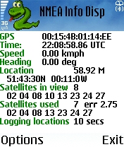
NMEA Info-A graphical Python program that talks to your GPS, and does useful things with the information. It is able to talk to a Bluetooth GPS (parsing the nmea data strea), or on S60 v3 phones with the LocationRequestor module, an internal GPS.
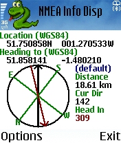
The program displays your current location, speed and heading, satellites in view, satellite signal strength, the time, distance and direction to a point, and more. It optionally also dumps positions to a file, which you can later get off to see where you went. It can take photos, and add the Geo Exif headers to tell you where you were when you took it (requires PExif). Can also log GSM location, for use with gsmloc.org.
Like it? Share with your friends!
If you got an error while installing Themes, Software or Games, please, read FAQ.