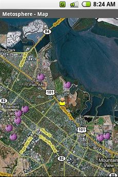
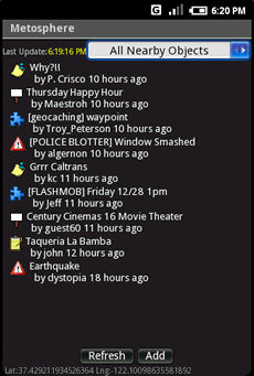
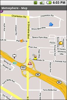
Metosphere Explore and create virtual objects around your physical location like messages, emergency alerts, events, news, reviews, games. View geospatial data from Wikipedia, Eventful, and Upcoming. Start a GeoBlog on your GPS-enabled phone.
This is the core Metosphere Android app. The goal is to follow the Firefox/Eclipse model and provide the ability to create extensions and add-ons like a Geocaching Assistant, Location Messaging Client, Proximity-based KML/GeoRSS Reader, Flash Mob Communicator, Community/Campus Emergency Alert Notifier, or even a Meatspace MUD game.
Like it? Share with your friends!
Supported operating systems:
Google Android 1.0, Google Android 1.5, Google Android 1.6, Google Android 10.x, Google Android 2.0, Google Android 2.1, Google Android 2.2, Google Android 2.3, Google Android 3.0, Google Android 3.1, Google Android 3.2, Google Android 4.0, Google Android 4.1, Google Android 4.2, Google Android 4.3, Google Android 4.4, Google Android 5.x, Google Android 6.x, Google Android 7.x, Google Android 8.x, Google Android 9.x
Similar Software:
GPS Tools GPS Tools - is an application for calibration of a satellite module of your smartphone. The utility uses a magnetic compass, makes changes to the route, speed and accuracy of the displayed data. As soon as the calibration is completed you can track your location with maximum accuracy
wheredroid wheredroid is a simple application to display your coordinates from the GPS receiver: latitude, longitude, heading, speed, number of satellites used and (it's its peculiarity) altitude and accuracy. It is quite usable as an altimeter and a compass.
What's New in This Release:
· fixes a bug inverting East with West on some displays
What's New in 1.4
GPS Info for Android GPS Info for Android is an easy to use and functional GPS application for beginners and advanced users. All needed GPS data is bundled in one screen with perfectly designed layout, with usability in mind
GpsFix GpsFix - Must have GPS application for your Android Phone.
GpsFix helps to decrease the time required to obtain a position fix.
It keeps GPS/AGPS receiver turned on until location is fixed.
It is useful when your navigation app says "waiting for location" too often
Current Location Finder Current Location Finder - Current Location finder which can be used to locate your location with the aid of a live satellite map you can dynamically (real time) determine ... Use the live satellite maps
GeoPix GeoPix - Headed to work or class? Want your school's mascot or company logo to show up as your wallpaper, "abracadabra" style, just as you arrive? Simply choose an image from Myxer’s massive catalog of wallpapers, or grab one from your phone, set the address- and watch it "auto-magically" appear as you reach your destination
Car Tracking Solutions Car Tracking Solutions is a provider of GPS Tracking and Vehicle Management. We provide a 24/7 monitoring service with operators standing by to assist you. We work hand on hand with the Royal Bahamas Police Force to assist with a quick response with vehicle recovery
Navitel Navigator Android “Navitel Navigator” is a unique and accurate navigation system. Detailed Russia map. Free traffic jams information service. SPEEDCAMs. The most detailed map of Russia: more than 118 000 cities and towns, 1500 of them contain address search information. The most detailed Moscow and Saint-Petersburg map
amAze (Motorola) AmAze is a first of its kind free navigation and local search service. It is free to download and use and it contains wide coverage of maps including aerial photo in Europe, North America, Australia and parts of Asia and Africa


")
")


")