Transit Maps USA Free - The only Transit Maps app of its kind. You can select the city you want to see the transit maps for and zoom in to view the map in detail on the full screen. You can easily zoom-in, pan, and zoom-out using one hand only. You can now plan your trip from anywhere, any time - no Internet/data connection required. Imagine having the ease of mind that you will always know what line to catch to go where you want to go.
Give it a try. Your satisfaction is guaranteed.
Please download and rate the app. Provide your feedback via the Marketplace - all comments are read and individually considered.
Tip: Double-tap the zoomed-in map to reset zoom.
The feature history of the application is as below:
Version 1.0 (Current Version)
====================
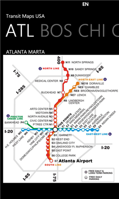
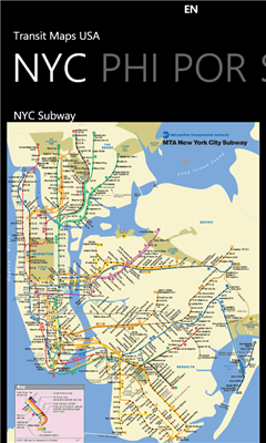
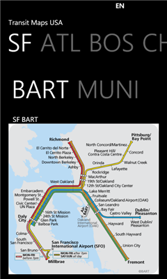
* Transit Maps available for following cities:
- Atlanta
- DC, Washington
- New York City
- San Francisco
* Supports Portrait and Landscape orientation modes
If you would like to get maps for more cities, get the full version of the app at http://social.zune.net/redirect?type=phoneApp&id=e8398409-b46f-e011-81d2-78e7d1fa76f8 The full version contains maps from Boston, Chicago, Los Angeles, Miami, Philadelphia, Portland and more cities.
Like it? Share with your friends!
If you got an error while installing Themes, Software or Games, please, read FAQ.
Supported operating systems:
Windows 10 Mobile, Windows Phone 7, Windows Phone 8
Similar Software:
Canada Topography Canada Topography - provides topographic information for the entire country of Canada. The maps provide details such as altitude, railways and numerous other layers. Using the GPS you can center on your current location and even zoom to specific areas of the country.
All maps are provided by Geocratis Canada (http://www.geogratis.gc.ca/geogratis/en/service/toporama
En Zaragoza En Zaragoza - Localiza cientos de lugares de interes de Zaragoza rapidamente a traves del mapa.
"En Zaragoza" es una aplicacion gratuita que permite localizar, mediante un mapa de la ciudad de Zaragoza, cientos de lugares de interes. Localiza centros de salud, estaciones Bizi, farmacias, parques, etc
Sun Locator Lite Sun Locator Lite - See a map of where the Sun is shining!
Sun Locator Lite displays a map showing the areas of night and day on the Earth. The map displays your current location and gives your current geographic coordinates.
No network coverage is needed to run this app
WorldMaps Developed by Salman Shakeel
This application provides you total solution to navigation it is combinations of multiple maps at one place
XMaps XMaps - With xMaps you have the possibility to use the worldwide map data from openstreetmaps.org on your phone. xMaps comes without any map data, you can download any maps in different zoom levels for free. You can zoom in / out and rotate and tilt the map.
Use xMaps to search a point by coordinate or to plan a travel route by car or by foot
GeoBC Showcase GeoBC Showcase - This app takes advantage of geospatial layers provided by GeoBC. It will include Federal Electoral Districts and Local Health areas plus Primary Survey Parcels in British Columbia, Canada.
Select one of the layers from the list, then press a point on the map and hold to get information about that geographical point
Bochum Total Diese Anwendung ist eine ubersicht uber alle Acts bei Bochum Total und das Bermuda-Dreieck
Bing Get Me There Bing Get Me There - Bing Get Me There is a London travel app that gets you from where you are right now to wherever you want to be. True door-to-door directions using Bing maps and live tube updates to ensure you get the best route for you
MapStalt Mini MapStalt Mini is an application that is meant to bring the map to completeness. In the case of the open street map, many details are missing, and MapStalt puts to power to complete the map into the hands of the mobile user. With MapStalt, a user can add something as simple as a building address and latitude/longitude or complex details such as business hours of operation
Artist This is an Artist application where a user can draw free hand like an artist and show their creations to their friends
NPR News NPR News - Now you can have your news on the go.
Select from various categories (Headlines, Business, Politics, US, World, Technology or Sports) and read individual news stories.
To view the full story, just select "open in ie" from the menu at the bottom of each article - this is currently a limitation of how NPR feeds are setup and not of the app itself
SketchPad SketchPad allows you to draw free hand on a canvas on your device using a vast color palette and to save your sketch to keep for memory and show it to others.
You can also load any existing image (or an already saved sketch) as a background and draw on that. You can do things like draw a moustache on someone's face; complete a saved sketch; or write messages for others
Tic Tac Toe Lite Tic Tac Toe Lite lets you play against the computer or your friend