Outdoor Speedometer for Android - The Outdoor Navigation software is your best friend through your adventures in the wild.
Go into the outdoors with confidence and enjoy your activities without worrying about the tools to help you navigate. Your Outdoor Navigation app is made by the people who have been developing this software since 2003 across multiple platforms. Be sure that you will stay ahead of the rest with continuous updates and relevant tools.
It is an excellent tool for biking, jogging, skiing, hiking, geocaching, boating, flying and many other sporting activities.
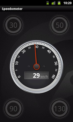
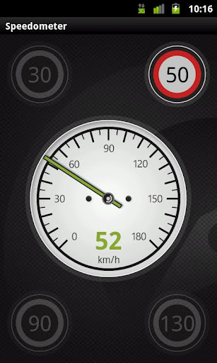
Your Outdoor Speedometer will give you the ability to see your current speed while you are enjoying your favorite activities on large easy to read dial displays. It uses multiple stylish layouts including car, bike, and even a plane.
You will have the ability to quickly set and change your current speed limit and receive accurate sound warnings if you have gone over your desired range.
· Shows current speed
· Car, bike and Plane layouts
· Speed limit tables with selectable speed limits
· Warning beep when speeding over the set limit!
Installation instructions:
Outdoor Speedometer is an add-on for the free Outdoor Navigation application. You need to have your Outdoor Navigation installed to be able to use Outdoor Speedometer.
Download and install Outdoor Speedometer on your Android device. Start the Outdoor Speedometer plugin to complete the license checking: when activation will be completed then the icon will be removed (you need to restart your device to hide the icon) and the plugin will be used inside Outdoor Navigation application.
What's New in This Release:
· Bug fixing
Like it? Share with your friends!
Supported operating systems:
Google Android 10.x, Google Android 2.1, Google Android 2.2, Google Android 2.3, Google Android 3.0, Google Android 3.1, Google Android 3.2, Google Android 4.0, Google Android 4.1, Google Android 4.2, Google Android 4.3, Google Android 4.4, Google Android 5.x, Google Android 6.x, Google Android 7.x, Google Android 8.x, Google Android 9.x
Similar Software:
SharpSol Pedometer Free SharpSol Pedometer Free - Adjust settings first.
Air Push ads completely removed in this update.
Facebook posting bug removed
resting values dialog added.
Speach API working 100% accurate now.
No popup ads.
absolutely free with charts support.
Welcome to SharpSol Pedometer
3D Compass (AR Compass) 3D Compass (AR Compass) - 3D compass with augmented reality view, Auto rotate map, Big heading degrees
This is a compass app with augmented reality view and real time map update, and provides real time location information
Epic Compass Epic Compass - When you are a traveler or lost in somewhere place, you must need a compass. Caompass can be used in outdoor and many activities you can do such as hiking, climbing, flying etc
Compass XL Compass XL - Compass XL is a tool to search bearings (azimuth) using the device built-in magnetic sensors and the device GPS. You can also easy switch from true North and magnetic North. The compass accuracy depends on the performance of your device. If it works perfectly, this means your sensors are perfect, too
iPocket Tools Deluxe Best deal EVER! Why pay for 9 applications that may not be as good, when you can get all of these quality applications in ONE? ✓Bubble Level ✓Caliper ✓Clinometer/Inclinometer
✓Flashlight ✓Plumb bob ✓Protractor ✓Ruler ✓Voice Battery Tool ✓Voice Compass
GPS Coordinates Converter GPS Coordinates Converter - With this app you can convert GPS coordinates from "degrees, minutes, decimal seconds" to "decimal degrees".
What's New in This Release:
· Locate your phone and show the coordinates
What's New in 2
Obama Compass Obama Compass - The Obama Compass shows what direction your android phone is pointing and displays a picture of Obama in the center. The Obama Compass displays North, East, South, West and varying degrees. Also shows your heading
Street Race Street Race - App for timing 1/4 mile runs and 0-60mph sprints. Upload your best timings and compare with results from other drivers.
Speedometer operates off phone GPS service. Accuracy is dependent on your phone and satellite reception.
To do a timing run, touch on of the buttons on the first screen
SpeedView An advanced speedometer application that offers lots of useful features.SpeedView uses the phone's built-in GPS system to show your current, maximum and average speed, as well as direction, total distance and time traveled. Suitable for running, car driving, biking or hiking
Genius Compass Genius Compass - Not all who wander are lost. With Genius Compass, you will be able to know your exact location along with coordinates of the latitude and longitude. You need not hold the phone parallel to the ground, to get the directions. The heading is fixed whether your phone is in landscape or portrait mode
Other Software by developer «GPS Tuner»:
GPS Tuner Atlas Full Version with South America Basic Map Content GPS Tuner Atlas Full Version with South America Basic Map Content is designed specifically for off-road use: its large buttons, selectable tool window size, multiple Compass views and the built-in Tele Atlas map makes it extremely user-friendly and reliable
GPS Tuner Essentials Full Version with Iberia Basic Map Content GPS Tuner Essentials Full Version with Iberia Basic Map Content is designed specifically for off-road use: its large buttons, selectable tool window size, multiple Compass views and the built-in Tele Atlas map makes it extremely user-friendly and reliable
Outdoor SOS for Android Outdoor SOS for Android - The Outdoor Navigation software is your best friend through your adventures in the wild.
Go into the outdoors with confidence and enjoy your activities without worrying about the tools to help you navigate. Your Outdoor Navigation app is made by the people who have been developing this software since 2003 across multiple platforms
GPS Tuner Essentials Full Version with Nordic Countries Basic Map Content GPS Tuner Essentials Full Version with Nordic Countries Basic Map Content is designed specifically for off-road use: its large buttons, selectable tool window size, multiple Compass views and the built-in Tele Atlas map makes it extremely user-friendly and reliable
GPS Tuner Essentials Full Version with Brazil Basic Map Content GPS Tuner Essentials Full Version with Brazil Basic Map Content is designed specifically for off-road use: its large buttons, selectable tool window size, multiple Compass views and the built-in Tele Atlas map makes it extremely user-friendly and reliable
Outdoor Share for Android Outdoor Share for Android - The Outdoor Navigation software is your best friend through your adventures in the wild.
Go into the outdoors with confidence and enjoy your activities without worrying about the tools to help you navigate. Your Outdoor Navigation app is made by the people who have been developing this software since 2003 across multiple platforms
Outdoor Offline Maps for Android Outdoor Offline Maps for Android - The Outdoor Navigation software is your best friend through your adventures in the wild.
Go into the outdoors with confidence and enjoy your activities without worrying about the tools to help you navigate. Your Outdoor Navigation app is made by the people who have been developing this software since 2003 across multiple platforms
GPS Tuner Atlas Full Version with Asia Pacific Basic Map Content GPS Tuner Atlas Full Version with Asia Pacific Basic Map Content is designed specifically for off-road use: its large buttons, selectable tool window size, multiple Compass views and the built-in Tele Atlas map makes it extremely user-friendly and reliable
GPS Tuner Essentials Full Version with Central Europe Basic Map Content GPS Tuner Essentials Full Version with Central Europe Basic Map Content is designed specifically for off-road use: its large buttons, selectable tool window size, multiple Compass views and the built-in Tele Atlas map makes it extremely user-friendly and reliable
GPS Tuner Essentials Full Version with Germany, Austria, Switzerland Basic Map Content GPS Tuner Essentials Full Version with Germany, Austria, Switzerland Basic Map Content is designed specifically for off-road use: its large buttons, selectable tool window size, multiple Compass views and the built-in Tele Atlas map makes it extremely user-friendly and reliable


")


