A-to-B is a Turn-by-Turn application built to demonstrate some of the capabilities of the ArcGIS API for Windows Phone.
Warning: The application is meant for demonstration purposes only! Do not rely solely on the suggested routes or instructions given by this application.
Features:
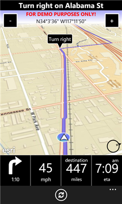
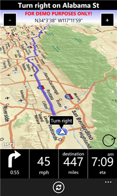
- Turn-by-turn routing. Sound notification when a turn is coming up.
- Add often used destinations as favorites.
- List of recent destinations.
- "3D view" when in navigation mode with easy accessible "zoom in/out" buttons.
- 2D Map for browsing the map supporting pinching, panning etc, and pick new destination by touch'n'hold on the map.
- Easy accessible "Recalculate" button if you go off the route and need a new route from your current location (because of service restrictions, the app is not allowed to do this automatically).
- Routes all over US (support for Europe coming in a future version).
- Worldwide map (detail may vary).
Like it? Share with your friends!
If you got an error while installing Themes, Software or Games, please, read FAQ.
Supported operating systems:
Windows 10 Mobile, Windows Phone 7, Windows Phone 8
Similar Software:
Parking Spot Parking Spot - Parking Finder application for metra areas and cities like San Francisco, CALIFORNIA and more cities comming soon.
See real-time availability, prices and Restricted Parking information for parking spaces on the streets and in parking garages
Reach That Point Reach That Point - With this application you can navigate from your current location to one of your favourite locations by following the on-screen compass information
GPS tracker GPS tracker - The app can be used to track the current position of the user using GPS data. Data that can be obtained are :
- Latitude
- Longitude
- Altitude
- Course ( Direction )
- Current Speed
The above said data can be sent as a referance using either SMS or E-Mail
EasyGpsTracker+ EasyGpsTracker+ - This application is an off-road navigator which tracks your position
on map and saves your route.
You may later recall the saved route and navigate through the same
route again.
It also provides support for finding addresses and calculating routes
Distant Distant tells you where places are in relation to where you are now. It lists your places in order of distance, and colour codes them so that it is easy to tell at a glance whether you are getting closer or further away. It also tells you how long it will take to get there if you keep moving at the current speed
WhereAmI This application simply shows you where you are by displaying your current latitude and longitude
YP Yellow Pages YP Yellow Pages - Need a cup of coffee, want to find a good pizza place in town? Like to read reviews before choosing a restaurant? The YP app is your easy-to-use guide for local info near you. Search. Find
GPS Share GPS Share is a free location sharing application. It allows GPS locations to be stored, rated and shared with others
Back Track Free Back Track allows you to easily view your current location and save your position. The saved location can be retrieved at a later time when you may need to find your way back. In addition, Back Track offers directions to help direct you back to the saved location along with a visual route and your current position
Back Track Free Back Track Free allows you to easily view your current location and save your position. The saved location can be retrieved at a later time when you may need to find your way back. In addition, Back Track offers directions to help direct you back to the saved location along with a visual route and your current position
Other Software by developer «Morten Nielsen»:
GuidePost GuidePost - This app creates a "Guide Post" with signs on a pole showing distances and direction to any point in the world, relative to where you are. You have probably seen these at various sites all over the world, or in the TV Show "M*A*S*H".
You can also display a map of your location and the shortest paths to your points of interest.
v1