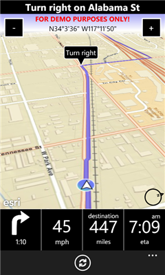
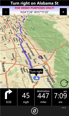
A-to-B is a Turn-by-Turn application built to demonstrate some of the capabilities of the ArcGIS API for Windows Phone.
Warning: The application is meant for demonstration purposes only! Do not rely solely on the suggested routes or instructions given by this application.
Features:
- Turn-by-turn routing. Sound notification when a turn is coming up.
- Add often used destinations as favorites.
- List of recent destinations.
- "3D view" when in navigation mode with easy accessible "zoom in/out" buttons.
- 2D Map for browsing the map supporting pinching, panning etc, and pick new destination by touch'n'hold on the map.
- Easy accessible "Recalculate" button if you go off the route and need a new route from your current location (because of service restrictions, the app is not allowed to do this automatically).
- Routes all over US (support for Europe coming in a future version).
- Worldwide map (detail may vary).
Like it? Share with your friends!
If you got an error while installing Themes, Software or Games, please, read FAQ.
Supported operating systems:
Windows 10 Mobile, Windows Phone 7, Windows Phone 8
Similar Software:
Locate'N Share Locate'N Share - Are you lost somewhere? Struggling to explain your location for a pick up? If answer is yes, here is the handy app you need to make it easier. This app allows to locate yourself and share the address with your friends or family members by text/email with directions to pick you up, without confusing them with ambiguous address
Find My Car Find My Car - Did you ever park your car and not remember where it was parked? It can be hard to find your car again in this situation. With this application it allows navigate from your current location to your car. It is also possible to store the parking ticket expiry time with a countdown
OS Grid Refs OS Grid Refs - A simple app that displays the phone's current location as an Ordnance Survey grid reference.
n.b. This will only be of use if the your current location lies inside the OS national grid. Using the app outside the UK will give no reading
JaefreyGPS Lite JaefreyGPS Lite This application enables you to view your current position and course. Furthermore you can record a track while walking or driving and upload this track as kml-file to your Dropbox account
Spot On Spot On - Features: . Save your favorites places with fotos, videos and memo record. Spot On will also lock your GPS cordinates so wi'll never forget that place.
. Share your current location with your friends through SMS or Email with an easy and instant way.
. Find points of interest near you (restaurants, bar, hotels etc...)
Geo32 for Windows Phone 7 Geo32 for Windows Phone 7 is a GPS coordinate in a format that is easy to read, remember and transmit. Transmitting or receiving locations has never been simpler.
The Windows 7 Phone Geo32 application will translate the GPS of your position (or anyone else's) into Geo32 code.
The problem: You arrange a meeting with a friend in town
Car Locator For Free Car Locator For Free - Just launch the app and record your location. When you want to find your car, just press a button and the app will show you the path to your vehicle, plus a photo to help visually identify the location. Now for free
Navigation Italy Navigation Italy - THIS IS A TOTALLY ONBOARD (OFFLINE) NAVIGATION APPLICATION, NO INTERNET CONNECTION IS NEEDED TO USE.
GPS ON - Turn by Turn gives you premium quality Voice-Guided driving directions on your Windows Phone. Just simply tap a point on a map or search address/POI, then click on the pushpin and press the GO button.
It is that simple
JaefreyGPS Pro JaefreyGPS Pro is the paid in and in functions enhanced version of JaefreyGPS lite.
With this application you can get your GPS position and the direction angle. Furthermore, the app allows the recording of unlimited tracks and uploading it as .kml or .gpx file in your Dropbox account. You can take various tools such as Google Maps to evaluate the path data
Other Software by developer «Morten Nielsen»:
GuidePost GuidePost - This app creates a "Guide Post" with signs on a pole showing distances and direction to any point in the world, relative to where you are. You have probably seen these at various sites all over the world, or in the TV Show "M*A*S*H".
You can also display a map of your location and the shortest paths to your points of interest.
v1