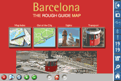
Rough Guides Map Barcelona... These guides are a series of fantastic interactive maps.
Produced in conjunction with the premier travel publisher Rough Guides.
Discover and explore Barcelona using full colour interactive linked maps, in this simple to use PDA version of The Rough Guides Barcelona.
Find all the top tourist spots and key attractions with ease, information on the city and its sights can be quickly displayed with links to photographs and map locations. All in a superb easy to use interface.
If you''re travelling to Barcelona, be sure you don''t leave home without this guide on your PDA.
The Rough Guide city maps includes:
Fully scrollable and interactive maps of the city.
Tap any location to display information and available links.
Intuitive navigation bar meaning you are never more than one click away from the information you require.
Map links allow you to directly link to other maps, photographs, or detailed views.
Categorised Find feature allowing you to quickly find any street, place of interest or station.
Categorised Information feature providing a wealth of information on the city, places of interest, etc.
1-Click Home feature, keeping the Home map always at hand.
Zoom function on all maps.
Special Offer Only $20.00
Hi Res & landscape displays supported.
Like it? Share with your friends!
If you got an error while installing Themes, Software or Games, please, read FAQ.
Supported operating systems:
Pocket PC 2002, Windows Mobile 2003, Windows Mobile 5.0, Windows Mobile 6 Classic, Windows Mobile 6 Professional, Windows Mobile 6.1 Classic, Windows Mobile 6.1 Professional, Windows Mobile 6.5 Professional
Similar Software:
Underground Maps Underground Maps - Contain maps of all Underground of europe. When you want go in the underground you must have Underground Maps that help you to find the rapid way! It's very important install program on Pocket PC and not on Memory Card Ecc.
Speereo Voice Translator: English-Turkish (WM) Speereo Voice Translator (SVT) is an ideal companion for traveling on business or leisure and also is an excellent aid for business communication. Running on Windows Mobile and Symbian based mobile devices it contains of over 4000 phrases in each of 16+ languages and many other useful features
MailGoogling MailGoogling allows you to enter a ZIP code or partial ZIP code and displays the ZIP code map and location
Map of Nicaragua Map of Nicaragua - A map of the Nicaragua by VITO Technology. Good for intercity travels with SmartMap.
SmartMap is a mobile device application which uses vector and raster maps. It is compatible with any NMEA protocol GPS receiver (Compact Flash socket, serial port, BlueTooth or sleeve)
Google Maps for mobile with Latitude Google Maps for mobile with Latitude is the official mobile mapping application from Google.
Features:
New! Google Latitude
Latitude lets you see your friends' locations and status messages. Share your location and status with select friends. Get started by selecting "Join Latitude" in the menu
A-Z Mini Birmingham Street Atlas A-Z Mini Birmingham Street Atlas - From the publishers of London''s best selling paperback street atlas comes this publication designed for a Windows® Mobile-based Pocket PC (version 2002 or later) and Pocket A-Z Viewer (included)
Traffic Vizzion Traffic Vizzion - IMPORTANT: Do not operate this product while driving; park the vehicle first. It is your sole responsibility to place, secure and use your mobile device in a manner that ensures safe driving
Tube 2 Chicago Pro (UIQ3) Tube 2 Chicago Pro (UIQ3) - This map package for Tube 2 consists of a fully scrollable detailed map of the Chicago metro & commuter rail system and linked street maps of central Chicago.
Plan journeys on the metro system, list details of the quickest routes and see a superb animated display of your journey tracking around the system map
Tube 2 Paris (UIQ3) Tube 2 Paris (UIQ3) - This map package for Tube 2 consists of a fully scrollable detailed map of the Paris metro and RER system.
Plan journeys on this system, list details of the quickest routes and see a superb animated display of your journey tracking around the system map
New York Subway for iPad by Zuti New York Subway for iPad by Zuti - The "New York Subway" application is a superb geographically based map and route planner for the New York public transport systems
TUBE Engine UIQ3 Tube 2 Engine - Save hours by automatically having the quickest routes to hand, with all the details you need including line changes, platform directions and accurate journey times.
No more confusion on your trips, route details include, direction of travel, end of line, towards information, and number of stops in each segment
New York Subway 10 for iPad New York Subway 10 - The “New York Subway” application is a superb geographically based map and route planner for the New York public transport systems
Tube New York City (Series 60) Tube New York City (Series 60) - Our highly acclaimed Tube application that guides you around the complex MTA subway system of New York City is now available for your Series 60 Symbian powered phone. An essential addition to your phone for locals and tourists alike.
· A detailed clear colour map of the transport system fully scrollable
Tube Philadelphia (Series 60) Tube Philadelphia (Series 60) - Our highly acclaimed Tube application that guides you around the rail system of Philadelphia is now available for your Series 60 Symbian powered phone. An essential addition to your phone for locals and tourists alike.
· A detailed clear colour map of the Philadelphia rail system fully scrollable.
· Quick find station utility
Tyne & Wear Metro by Zuti Tyne & Wear Metro by Zuti - The new Tyne & Wear Metro map makes it easy to travel in and around the city using the Nexus Metro system. Unlike old fashioned schematic style maps this product contains a geographically accurate central area showing major streets, parks and places of interest etc, allowing the user to easily get their bearings
Tube 2 Portland (Palm OS) Tube 2 Portland (Palm OS) - This map package for Tube 2 consists of a fully scrollable detailed map of the Portland rail system.
Plan journeys on this system, list details of the quickest routes and see a superb animated display of your journey tracking around the system map
Rough Guides Map Amsterdam Rough Guides Map Amsterdam... These guides are a series of fantastic interactive maps.
Produced in conjunction with the premier travel publisher Rough Guides.
Discover and explore Amsterdam using full colour interactive linked maps, in this simple to use PDA version of The Rough Guides Amsterdam


 Hi Res & landscape displays supported.
")

![USA-ME [Maine] Map for EagleEye PDA Tracking System](https://static.mobyware.org/data/images/def_program_reduced.png "USA-ME [Maine] Map for EagleEye PDA Tracking System")


")
")


")
")

")
