Symbian OS | Pocket PC | Smartphone | Android | BlackBerry | Apple iPhone OS | Java | Mobile Gaming | Linux | Palm | Win CE | Tablet  
     

Free Mobile Software, Themes, Games, Apps for PDA and Smartphones

     
Search by Device
My Device

  
Last Viewed Apps
Gravity gun
Doodle Defense for Android
Search by Category
Business & Profession
Databases
Dictionary & Translator
Entertainment
Finance
Games
Healthcare & Medicine
Internet & Communications
Multimedia & Graphics
Organisation & Productivity
Programming & Development
Reading
Science & Education
System Utilities
Themes & Wallpapers & Skins
Travel & Navigation
Search by Platform
Android
Apple iPhone OS
iPad
iPhone
iPod Touch
BlackBerry
Java
Linux
Maemo Nokia Internet Tablet
MeeGO
Sharp Zaurus
Mobile Gaming
Nintendo DS
Playstation 3
Playstation Portable
Wii
Xbox 360
Palm OS
Symbian OS
Series 60
Series 80
Series 90
UIQ
Tablet PC
Windows CE.NET
Windows Mobile Pocket PC
Windows Mobile Smartphone


Achivx Partner
 
 
NaviPOWM


NaviPOWM
Version: 0.2.6 updated

Platforms: Pocket PC


Categories: Travel & Navigation

Upload date: 4 Aug 11

Developer: Julian Bugariu

License: Freeware

Downloads: 10095

File Size: 1660 Kb
Download Free NaviPOWM 


Rating: 3.0/5 (Total votes: 22)


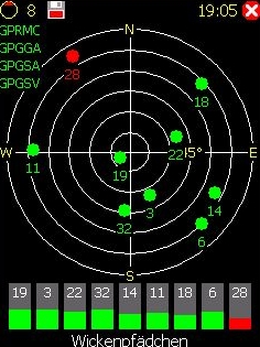
NaviPOWM is a car navigation system capable of running on a variety of operating systems. Only OSM based map data is supported. Realtime routing engine is planned in a later version. Geocaching and city guide functionality are also planned.
other:
· more POI types
· more way types
· support more targets at once
· switch between targets by clicking on target display
· coastlines bugfixing

What's New in This Release:

fixed bugs:
· crash under Windows XP when displaying areas with holes
· areas with holes not drawn properly on Windows mobile

implemented feature requests:
· Support for gpsd

What's New in 0.2.5:

fixed bugs:
· TrackLog must show real GPSCoor

implemented feature requests:
· No aygshell.dll on PNA systems
· Show oneway arrow on streets
· Visibility of speed-pos box adjustable
· Save received data also as GPX file

other:
· area display (sea) speedup
· reorganized directories
· support for CMake


Like it? Share with your friends!

If you got an error while installing Themes, Software or Games, please, read FAQ.
 

Supported operating systems: Windows Mobile 2003, Windows Mobile 5.0, Windows Mobile 6 Classic, Windows Mobile 6 Professional, Windows Mobile 6.1 Classic, Windows Mobile 6.1 Professional, Windows Mobile 6.5 Professional
 
Similar Software:

EagleEye PDA Tracking System for HW6500/HW6900 SeriesEagleEye PDA Tracking System for HW6500/HW6900 Series
EagleEye PDA Tracking System for HW6500/HW6900 Series - We at Targex Corp. have been in the vehicle tracking business for over 10 years, researching and offering products that are advanced and extremely reliable
Location Tracker SDKLocation Tracker SDK
Location Tracker SDK - Includes client software capable of reading from bluetooth enabled GPS receiver as well as a .NET assembly that will receive lattitude and longitude information wireless for plotting in your mapping solution of choice
Kai's GPS Tracker.NetKai's GPS Tracker.Net
With the GPS Tracker you send your Position via 'SMS' or 'SMS to e-mail' to another person and tell him/her so your location. The recipient gets a SMS or e-mail with the location and a link to a map (on PC). Use it for your friends, family or in a company. Also suited to send holiday greetings from a foreign country
FON Access Points for MexicoFON Access Points for Mexico
FON Access Points for Mexico - FON offers you a new Points of Interest service (POIs). This allows you to download FONspots directly to your navigation device. What does that mean? You can download a Points of Interest file directly to your navigation device
ExcelGPSsExcelGPSs
ExcelGPSs - ExcelGPSs can be used to make Excel sheets with a GPS tag as the sheet file name. Each time you make a sheet the sheet is named the latitude and longitude of the file. You can store your files on the storage card. You can also view the Excels with Google maps. This program requires that you have both the 'BeanDLL
FON Access Points for IsraelFON Access Points for Israel
FON Access Points for Israel - FON offers you a new Points of Interest service (POIs). This allows you to download FONspots directly to your navigation device. What does that mean? You can download a Points of Interest file directly to your navigation device
BlueWave GPSBlueWave GPS
Displays GPS navigational information for boating
ContactGPSerContactGPSer
ContactGPSer allows you to create and view phone/SMS/email contact number '.cgps' links and Dial/SMS or Email the contacts via GPS distance. Select 'Start GPS' to get a GPS lock and create a new '.pgps' contact link. The program displays the distance between each contact via your current GPS
OS GPS ConvertorOS GPS Convertor
OS GPS Convertor converts positions between WGS84 latitude & longitude and Ordnance Survey (OS) British & Irish or Universal Transverse Mercator (UTM) worldwide grid references. It displays positions in multiple formats. It can be used with:  * TomTom Navigator - to create a Point of Interest (POI) or Itinerary file ... then show on map, navigate to, etc
GPSPOIerGPSPOIer
GPSPOIer can be used to create GPS tagged POI points with custom names
 

Other Software by developer «Julian Bugariu»:

not found
 

Comments on NaviPOWM:

Comments not found

Name:


Comment:


Enter text from image below:

Turn on images!


If you noted an error or download link is broken, please, report it via this page or use comments.
 

NaviPOWM is compatible with your device Datalogic Mobile Falcon GUN 4420
 
 
© Pantich 2009 - 2025 All rights reserved.