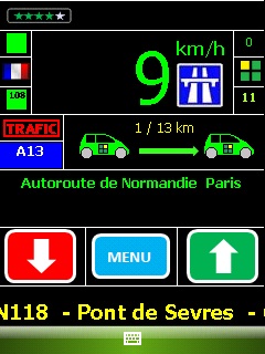
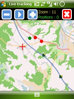
Mobbyway - Based on both internet mobile technologies and GPS, Mobbyway allows you to know easily, at any time, your relatives’ exact position on a map if they have accepted it and if they are connected to the network.
Mobbyway is also a help on the road network with a local alert system of a dangerous zone which is carried out with the network of members. Finally, Mobbyway will reference all the fixed radars in the countries where it is used and Mobbyway will indicate them to you.
Mobbyway was developed to allow:
- you to stay connected with your relatives wherever they are.
- your relatives to follow you visually and in real time.
- you to go back at any time to a place where you have already been on a specific date.
- you to travel safely on the road network thanks to the network members: The Mobbynautes.
- you to have a part in the world cartography OpenStreet Map
Like it? Share with your friends!
If you got an error while installing Themes, Software or Games, please, read FAQ.
Supported operating systems:
Windows Mobile 6 Classic, Windows Mobile 6 Professional, Windows Mobile 6.1 Classic, Windows Mobile 6.1 Professional, Windows Mobile 6.5 Professional
Similar Software:
GPS Tuner Essentials Full Version with Brazil Basic Map Content GPS Tuner Essentials Full Version with Brazil Basic Map Content is designed specifically for off-road use: its large buttons, selectable tool window size, multiple Compass views and the built-in Tele Atlas map makes it extremely user-friendly and reliable
e-Mobile GPS Traffic e-Mobile GPS Traffic
Receive real-time traffic information from your hand. Get all you need to know about the traffic condition around town.
Live traffic flow and traffic incidents report.
Get directions and traffic conditions to a point of interest with detailed map
RulerGPSer RulerGPSer - RulerGPSer uses the GPS on your PocketPC to view and download GPS marked satellite camera pictures and calculates distance between two points specified by the latitude/longitude of your GPS using "The Vincenty inverse formula for ellipsoids." (accuracy to within 0.5mm, or 0.000015")
This program requires that you have both the 'BeanDLL
GPSLoggerer GPSLoggerer logs and displays the data that comes from your GPS unit in your device in NMEA sentences. You can select the output to a NMEA extension or or text file extension. When you select save all logs after the save will be saved to the file. When you select close the logging will stop
SirfTech Pocket PC program for checking and setting practically all SiRF GPS settings and evaluating changes
TravelEncyclopediaer TravelEncyclopediaer uses the GPS on your PocketPC to find your current latitude/ longitude/ speed/ altitude and looks up the Wikipedia.org GPS listings and displays them. Tap the button to start the GPS and when you get the lock tap the button again to view the Wikipedia.org listings for the area. This service is provided by Geonames
ExercisesGPSs ExercisesGPSs - ExercisesGPSs uses the GPS on your PocketPC to measure your speed/walking/running speed. The program displays your speed in Km/h with 3-digit accuracy. NOTE: Use caution when exercising and using this program.
This program requires that you have both the 'BeanDLL.dll' file ** and ** the runtime files for Visual Basic on your PocketPC computer
GPS Compass GPS tools to read device’s heading from device GPS
BT747 MTK GPS Datalogger Device Control BT747 MTK GPS Datalogger Device Control - i-Blue 747 / i-Blue 757 / Qstarz BT-Q1000 / i.Trek Z1 / Konet BGL-32 / Holux M-241 / ... control SW (for PalmOS, WinCe (PPC), Java platform, Windows, Linux, and MacOS). Compatible with most MTK GPS based loggers
PoliceGPSes PoliceGPSes - PoliceGPSes can be used to track suspects that you are using the PocketPC PoliceGPSer's locator on. You can make a file for each group of locators and view the current latitude/longitude/speed and altitude of each GPS locator on the Google.com maps site.
This program requires that you have both the 'BeanDLL
Other Software by developer «Mobbyway»:
Mobbyway Mobbyway based on both internet mobile technologies and GPS, Mobbyway allows you to know easily, at any time, your relatives’ exact position on a map if they have accepted it and if they are connected to the network.Mobbyway is also a help on the road network with a local alert system of a dangerous zone which is carried out with the network of members


")
")