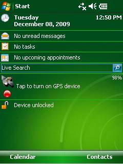
GPS2day is a today screen plug-in showing your current GPS coordinates, speed, satellite info, etc... Languages: English, Czech, Dutch, French, German, Hungarian, Italian, Japanese, Polish, Russian, Spanish.
Currently GPS2day program works as GPS informer. It supports both metric and U.S. (Imperial) units and shows a various types of information for users, such as:
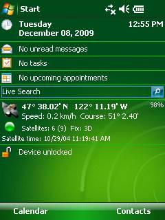
Current geographical coordinates (latitude, longitude);
Course and speed;
Some information about satellites and fix type;
Altitude followed by the fix 3D value;
Exact current date and time from the satellite atomic clock;
And battery life state which is important when you using GPS device.
What's New in This Release:
· Translation to Japanese was added
Like it? Share with your friends!
If you got an error while installing Themes, Software or Games, please, read FAQ.
Supported operating systems:
Windows Mobile 5.0, Windows Mobile 6 Classic, Windows Mobile 6 Professional, Windows Mobile 6.1 Classic, Windows Mobile 6.1 Professional, Windows Mobile 6.5 Professional
Similar Software:
BikeDashboard BikeDashboard-This application provides training assistance (through graphs and stats) + navigation help (with moving maps and GPX file import & export) for mountainbike and roadbike enthusiasts.
BikeDashboard Features:
* Keep a track of their achievements:
o Where they have been.
o How long.
o How fast
Glympse Glympse is the easiest, most flexible way to safely share your location. Just a couple clicks, and you can decide who and for how long your friends can see your location on a map.
How it works:
Send a Glympse - Share your location from a mobile smartphone.
Receive a Glympse - View a shared location on either a computer or mobile smartphone
PouchHiker Drivers see hitchhikers and carpoolers and their destination. Hitchhikers/carpoolers can make themselves visible to drivers
GPSMeter PDA GPSMeter PDA is program allows you to measure areas of any geometry, distances and to mark fixpoints
BT747 MTK GPS Datalogger Device Control BT747 MTK GPS Datalogger Device Control - i-Blue 747 / i-Blue 757 / Qstarz BT-Q1000 / i.Trek Z1 / Konet BGL-32 / Holux M-241 / ... control SW (for PalmOS, WinCe (PPC), Java platform, Windows, Linux, and MacOS). Compatible with most MTK GPS based loggers
FON Access Points for Turkey FON Access Points for Turkey - FON offers you a new Points of Interest service (POIs). This allows you to download FONspots directly to your navigation device.
What does that mean? You can download a Points of Interest file directly to your navigation device
GSz GSz is an application that shows you around nice restaurants whenever you need.
· Search Restaurants by
· "Area/Station/Restaurant Name/GPS location".
· Restaurant information (Name/TEL/Address/Business Hours/Budget/etc...)
· GPS Monitor.
· Mobile GoogleMap
FON Access Points for Palestinian Territory FON Access Points for Palestinian Territory - FON offers you a new Points of Interest service (POIs). This allows you to download FONspots directly to your navigation device.
What does that mean? You can download a Points of Interest file directly to your navigation device
CoffeeTimHortons CoffeeTimHortons uses the GPS on your PocketPC to find the 50 closest Tim Hortons shops sorted via GPS distance. Tap the button to start the GPS and when you get a lock tap on it to view the list of local Tim Hortons shops. You can also dial the store. The GPS maps and search service is provided by Google
Navigation BE-ON-ROAD UK and Eire Q2/2011 Navigation BE-ON-ROAD UK and Eire Q2/2011 - The new major version of be-on-road presents new features and is based on new platform which brings high level of reliability, portability and speed on almost any kind of device. The new be-on-road brings high value voice guided door-to-door navigation
Other Software by developer «Soft Expanse Group»:
ShellSwitcher ShellSwitcher was implemented as a Windows Mobile system utility for fast switching between well known shells: Spb Mobile Shell, Titanium (WM6.5 default shell), Touch Flo 3D, HTC Sense and classic Today screen. This application is based on UI Switcher knowledge with some additional features

")