mdNavMobile is a waypoint-based GPS navigation solution for the Windows Mobile platform. It can guide you from waypoint to waypoint while keeping you informed of all relevant navigation data. All NMEA-data from a GPS is automatically logged to file so you can 'replay' a trip with variable speed.
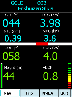
· GPS info: Latitude, Longitude, COG, SOG, Height, Satellites, HDOP and NMEA-stream
· Waypoint info: CTS, DTG, TTG, VMG, XTE
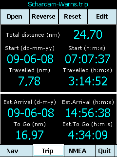
· Trip info: Total distance, Start, Travelled distance/time, DTG, TTG, ETA
· Reverse and Reset trips
· Scroll to next/previous waypoint
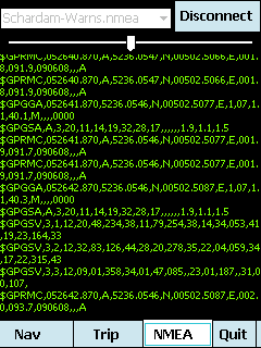
· Logs full NMEA stream from GPS to Storage Card
· Simulation using NMEA-log files with variable speed (factor 0.01-100)
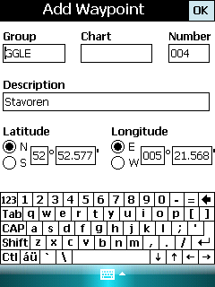
· Create/Edit Trips and Waypoints
· Show data in nm/kts/ft or km/kmh/m
· Change colors
· Trip-files also editable with notepad
· Totally free
Like it? Share with your friends!
If you got an error while installing Themes, Software or Games, please, read FAQ.
Supported operating systems:
Windows Mobile 5.0, Windows Mobile 6 Classic, Windows Mobile 6 Professional, Windows Mobile 6.1 Classic, Windows Mobile 6.1 Professional, Windows Mobile 6.5 Professional
Similar Software:
Terracrosser Terracrosser is a free GPS navigation software for Windows Mobile Pocket PC.
· Terracrosser works in Map and Photo modes
· Terracrosser uses zoomable maps
· Terracrosser is completely compatible with Google Maps service. With included Mapper module you can download maps from the Internet
SmokeGPSs SmokeGPSs - SmokeGPSs can be used to with GPS to help you to daily reduce the amount you smoke until you quit. For each day the program tracks the GPS location of each time you smoke and the total count for the day. You can also view the entries on a calendar interface.
This program requires that you have both the 'BeanDLL
NoteGPSer NoteGPSer - NoteGPSer allows you to make drawing/voice notes and attaches a GPS tag to the end of the file. You can also view the notes via GPS distance from your current GPS using "The Vincenty inverse formula for ellipsoids." (accuracy to within 0.5mm, or 0.000015")
This program requires that you have both the 'BeanDLL
ReliRescue GPS ReliRescue ("Reli Search & Rescue") enables your Windows Mobile Phone to broadcast your location to designated partners (over SMS or email). Your location is obtained using Integrated or external (Bluetooth) GPS connected to your device.
This utility also enables any Windows Mobile platform to feed the broadcasted waypoints to track and locate the sender
FON Access Points for Bulgaria FON Access Points for Bulgaria - FON offers you a new Points of Interest service (POIs). This allows you to download FONspots directly to your navigation device.
What does that mean? You can download a Points of Interest file directly to your navigation device
CoffeeGoogler CoffeeGoogler uses the GPS on your PocketPC to find the 50 closest coffee shops sorted via GPS distance. Tap the button to start the GPS and when you get a lock tap on it to view the list of local coffee shops. You can also dial the store. The GPS maps and coffee search service is provided by Google
GSz GSz is an application that shows you around nice restaurants whenever you need.
· Search Restaurants by
· "Area/Station/Restaurant Name/GPS location".
· Restaurant information (Name/TEL/Address/Business Hours/Budget/etc...)
· GPS Monitor.
· Mobile GoogleMap
FON Access Points for Martinique FON Access Points for Martinique - FON offers you a new Points of Interest service (POIs). This allows you to download FONspots directly to your navigation device.
What does that mean? You can download a Points of Interest file directly to your navigation device
Franson GpsGate Franson GpsGate -Share, simlulate and log the GPS
Share - GpsGate lets you share one GPS between several applications. GpsGate can create any number of virtual serial ports which most NMEA enabled GPS applications can connect to
Navigation BE-ON-ROAD UK and Eire Q2/2011 Navigation BE-ON-ROAD UK and Eire Q2/2011 - The new major version of be-on-road presents new features and is based on new platform which brings high level of reliability, portability and speed on almost any kind of device. The new be-on-road brings high value voice guided door-to-door navigation
Other Software by developer «Maurits Dijkens»:
not found
Comments on mdNavMobile:
Comments not found
If you noted an error or download link is broken, please, report it via this page or use comments.
mdNavMobile is compatible with your device Dopod P800 (HTC Artemis 110)

")