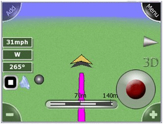
GPS NUT - GPS NUT is a GPS logger allowing you to log GPS tracks while you hike, bike, or drive. Also, load waypoints planned on Google Earth in the KML format to help guide you on to your destinations.
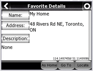
GPS NUT allows you to save GPS waypoints with detailed information to help you find anything. You can store the location of your car in a large parking lot or share the location of a scenic view with others using Google Earth.
· Save GPS logs in Google Earth's KML format.
· Save and Load detailed GPS waypoints in KML format.
· "Locate" items in an hour or a year from now. Find your car in a large mall parking lot or the perfect view atop a nearby mountain. GPS NUT will point to any stored location.
Like it? Share with your friends!
If you got an error while installing Themes, Software or Games, please, read FAQ.
Supported operating systems:
Windows Mobile 6 Classic, Windows Mobile 6 Professional, Windows Mobile 6.1 Classic, Windows Mobile 6.1 Professional, Windows Mobile 6.5 Professional
Similar Software:
ppc PhotoGeoTag ppc PhotoGeoTag - Take pictures with your mobile phone and incorporate the data of the geographical location. The application allows you to include in the photographs, data from the GPS receiver, along with a brief note. If you know the coordinates, not having the GPS receiver, you can also handwrite geographic data
FON Access Points for Brazil FON Access Points for Brazil - FON offers you a new Points of Interest service (POIs). This allows you to download FONspots directly to your navigation device.What does that mean? You can download a Points of Interest file directly to your navigation device
TextGPSs TextGPSs - TextGPSs can be used to make text notes with a GPS tag as the text file name and view the distance in meters of each text file in distance order via GPS. You can store your files on the storage card. You can also view the text entries with Google maps.
This program requires that you have both the 'BeanDLL
FON Access Points for Vietnam FON Access Points for Vietnam - FON offers you a new Points of Interest service (POIs). This allows you to download FONspots directly to your navigation device.
What does that mean? You can download a Points of Interest file directly to your navigation device
TrakPal PitStop TrakPal PitStop - Analyse your performance using NMEA compliant GPS data recorded on your Pocket PC - the perfect complement to your GPS navigation software.
Compare data from different runs to find where those important seconds were lost, whether on the track, training, commuting or just for fun
LocationSMS LocateSMS permit to include your GPS-coordinates into a SMS
GPSAltimeterer GPSAltimeterer uses the GPS on your PocketPC to find your altitude. You can view in Meters or Feet. This can be used on a plane that does not allow full GPS. Start the program to find your height via GPS on it. NOTE: Make sure you are allowed to use this program before starting the application
TravelWiFier TravelWiFier - TravelWiFier can be used to log WiFi hotspots via GPS. Each time you find a hotspot you can create a new 'WiFi' file with the current GPS and login information. When you are traveling the program uses the GPS on your PocketPC to find the closest WiFi hotspot and displays the distance.
This program requires that you have both the 'BeanDLL
TextPOIs TextPOIs - TextPOIs can be used to create and edit compact text notes of any length and places the GPS tag at the end of the file. You can view the text files via your current GPS. You can view the text notes via your current GPS distance in real time and edit the text
GPS Mod Driver GPS Mod Driver - This Driver installs between your GPS application and the GPSID driver that reads the hardware GPS data. Lag is compensated, by guessing your position 'some number' of milliseconds in the future, current course and speed changes are included in the guess
Other Software by developer «Novlum»:
not found
Comments on GPS NUT:
1adam12:
fails to install on palm treo 800w
Date: 12 Jul 11
If you noted an error or download link is broken, please, report it via this page or use comments.
GPS NUT is compatible with your device Emobile Emonster S11HT