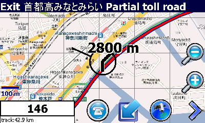
Mobile Traveler enables you when you are traveling abroad (e.g. Japan) to find your way around there. It uses Google to find routes and enables pre-fetching parts of Google maps at home or any where you have WiFi or cheap data rates of your mobile telephone provider. Besides this it is especially useful when you are visiting Japan. Traveling in Japan with the public transport is very safe and a fast way to move around. MobileTraveler contains almost all Japans Honsu area train lines and all shinkansen tracks. And best of all it's freeware
What's New in This Release
· Updated because of bug that slowly fills main memory when downloading tiles is on. This due to the fact that they where stored in the main memory instead of the storage card.
Like it? Share with your friends!
If you got an error while installing Themes, Software or Games, please, read FAQ.
Supported operating systems:
Windows Mobile 5.0, Windows Mobile 5.0 Smartphone, Windows Mobile 6 Classic, Windows Mobile 6 Professional, Windows Mobile 6 Standard, Windows Mobile 6.1 Classic, Windows Mobile 6.1 Professional, Windows Mobile 6.1 Standard, Windows Mobile 6.5 Professional, Windows Mobile 6.5 Standard
Similar Software:
MobileMaps MobileMaps - This program connects you to pda.maporama.com, an online map service. NOTE: You must be connected to the internet to use this program.
This program requires that you have both the 'BeanDLL.dll' file ** and ** the runtime files for Visual Basic on your PocketPC computer
Tube 2 Engine (Pocket PC) Tube 2 Engine (Pocket PC) - Transform your PDA into a fully scrollable detailed map of one of the worlds subway or metro systems.
See your journeys come alive with a superb animated display.
Save hours by automatically having the quickest routes to hand, with all the details you need including line changes, platform directions and accurate journey times
Tube Paris Pro (2009 Edition) Tube Paris Pro
New release with GPS support.
Tube plans all your journeys for you on the Paris metro & RER systems. It gives you the quickest routes, detailed on what trains to take and in what direction plus, service running times, fare zones, ticketing information and lots more...
Map of Rhode Island (US State) Map of Rhode Island (US State) - A map of the Rhode Island by VITO Technology. Good for intercity travels with SmartMap.
SmartMap is a mobile device application which uses vector and raster maps. It is compatible with any NMEA protocol GPS receiver (Compact Flash socket, serial port, BlueTooth or sleeve)
Map of Pennsylvania (US State) Map of Pennsylvania (US State) - A map of the Pennsylvania by VITO Technology. Good for intercity travels with SmartMap.
SmartMap is a mobile device application which uses vector and raster maps. It is compatible with any NMEA protocol GPS receiver (Compact Flash socket, serial port, BlueTooth or sleeve)
PrettyEarth PrettyEarth
View maps of Earth with PrettyEarth! See current day and night regions, learn geography by taking the quiz, enjoy relief elevation surfaces and measure distances between locations
Google Maps Mobile WM Street View on your phone, as well as business reviews and walking directions
Take the power of Google Maps with you on your mobile phone.
Real-time traffic — See where the congestion is, and estimate delays in over 30 major US metropolitan areas
Pocket Atlas 2007 Pocket Atlas 2007 - Topographical world atlas with relief elevations, rivers, inland waterways, roads and cities. Oceans with depth contours. Easy to use. Three Zoom steps to show map extracts down to 80 miles across. You can move the maps with a stylus or joystick and measure distances between any two points. Fast display of map extracts
Other Software by developer «MobileTraveler»:
not found
Comments on MobileTraveler:
nestor freitas:
por enquanto nada a comentar
Date: 26 May 10
If you noted an error or download link is broken, please, report it via this page or use comments.
MobileTraveler is compatible with your device Fly PC 100 (TechFaith PDA-L)

")


")
")

")
")

![USA-FL [Florida] Map for EagleEye PDA Tracking System](https://static.mobyware.org/data/images/def_program_reduced.png "USA-FL [Florida] Map for EagleEye PDA Tracking System")

