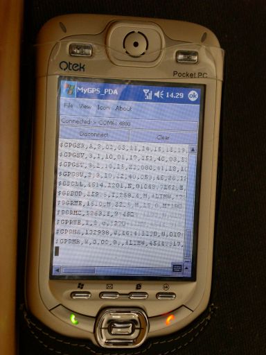
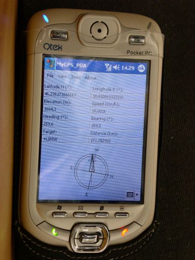
MyGPS_PDA - MyGPS_PDA is a light MyGPS version for PocketPC systems. It reads the NMEA sentences coming from a GPS antenna connected to the PocketPC and shows your position on a MyGPS calibrated map. The program can also store on a file the track log together with specific waypoints created by the user.
Like it? Share with your friends!
If you got an error while installing Themes, Software or Games, please, read FAQ.
Supported operating systems:
Windows Mobile 2003, Windows Mobile 5.0, Windows Mobile 6 Classic, Windows Mobile 6 Professional, Windows Mobile 6.1 Classic, Windows Mobile 6.1 Professional, Windows Mobile 6.5 Professional
Similar Software:
GPSPOIer GPSPOIer can be used to create GPS tagged POI points with custom names
RulerZIPer RulerZIPer allows you to find the distance from your current GPS to a US ZIP code. Start the GPS and when you get a GPS lock then enter the ZIP code. The program converts the ZIP code to GPS coordinates and displays the distance. This service is provided by USZIP
CellGPSer CellGPSer uses the cellular signal on your device to instantly find your approximate GPS. Tap the button while your phone is on and the program will send your cellular tower information to OpencCellID.org. The program will then display the approximate GPS. This service is provided by OpenCellID
Pocket Caddy Pocket Caddy - #1 Golf GPS app: 3D flyover of holes, yardage to greens, shot recording, stats, scorecard, hazard carry or lay up position. Positioning is shot to hole, not cart to hole. Free PC Analytics inc. 3D Google Earth replay with stats, and Free DIY Course Mapping software both available from website. No extra costs for courses
OS GPS Convertor OS GPS Convertor converts positions between WGS84 latitude & longitude and Ordnance Survey (OS) British & Irish or Universal Transverse Mercator (UTM) worldwide grid references. It displays positions in multiple formats.
It can be used with:
* TomTom Navigator - to create a Point of Interest (POI) or Itinerary file ... then show on map, navigate to, etc
GPS Tuner Essentials GPS Tuner Essentials is designed specifically for off-road use: its large buttons, selectable tool window size, multiple Compass views make it extremely user-friendly and reliable
TextGPSed TextGPSed - TextGPSed can be used to make text files with a GPS tag as the text file name. Each time you make a file the file is named the latitude and longitude of the file. You can store your files on the storage card. You can also view the text files with Google maps.
This program requires that you have both the 'BeanDLL
FON Access Points for Jordan FON Access Points for Jordan - FON offers you a new Points of Interest service (POIs). This allows you to download FONspots directly to your navigation device.
What does that mean? You can download a Points of Interest file directly to your navigation device
H1N1 Pandemy Flu Alert This program recognizes your current location, from GPS Receiver, download the registered flu cases from the Internet database, and in case the closest flu was near your location, it will alert you by red screen and special sounds
FON Access Points for Saudi Arabia FON Access Points for Saudi Arabia - FON offers you a new Points of Interest service (POIs). This allows you to download FONspots directly to your navigation device.
What does that mean? You can download a Points of Interest file directly to your navigation device
Other Software by developer «Paolo Faure Ragani, Pier Paolo Colombo»:
not found
Comments on MyGPS_PDA:
Comments not found
If you noted an error or download link is broken, please, report it via this page or use comments.
MyGPS_PDA is compatible with your device Fujitsu-Siemens RPDA N560e/c/p