EcoDrive Free Speedometer - EcoDrive Free Speedometer - accurate and convenient GPS speedometer.
The app is designed to control the speed, economy, time, direction, etc.
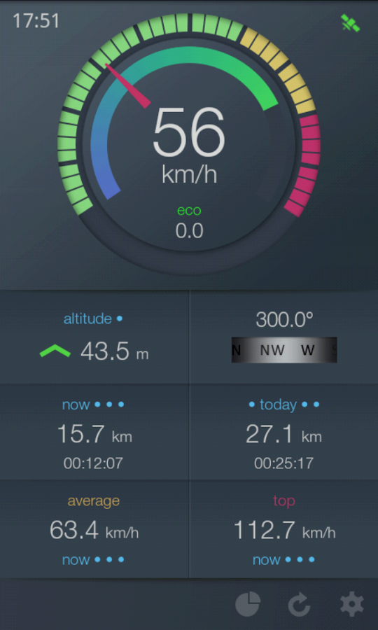
Real-time economy calculations is based on the speed, acceleration and braking, descents and ascents.
Flexibly adjustable speedometer scale allows to use the app on different types of transport: car, motorbike or bicycle, yacht or boat, and in any sports where is important speed, acceleration, time, etc.
All information about the speed, duration, acceleration and economy for different periods of time is saved and displayed in a convenient way.
Key features:
- Speedometer with flexible adjustable scale
- Determination of relative economy of movement
- Selection of units (U.S. and metric system of units)
- Audible alarm on exceeding the set speed (three adjustable parameters)
- Floating speedometer window on top of other apps
- Background work
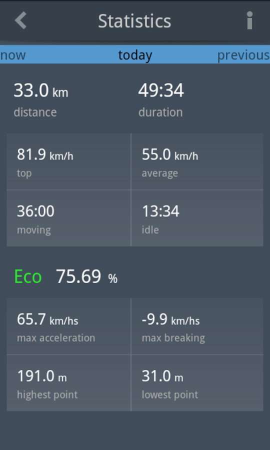
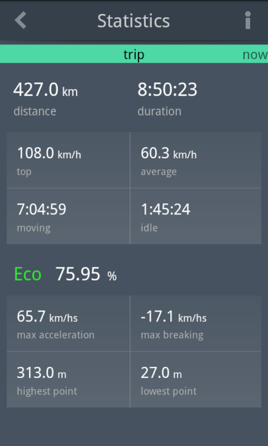
Statistics:
- Instantaneous, average and maximum speed for different periods of time
- mileage
- Duration of move
- Direction of movement (compass)
- Instantaneous and average economy
Supported operating systems:
Google Android 10.x, Google Android 2.2, Google Android 2.3, Google Android 3.0, Google Android 3.1, Google Android 3.2, Google Android 4.0, Google Android 4.1, Google Android 4.2, Google Android 4.3, Google Android 4.4, Google Android 5.x, Google Android 6.x, Google Android 7.x, Google Android 8.x, Google Android 9.x
Similar Software:
LocationFinder LocationFinder is a LBS application. Through this application you can search any location in map. Click anywhere in map and you find the area, nearest city and country. Apart from this, user can edit any location for search and can see the location in map
AlpineQuest AlpineQuest - AlpineQuest turns your Android device into an off-road GPS using offline topo maps. It is a complete solution for all outdoor activities and sports, including hiking, running, trailing, hunting, sailing, geocaching and much more
AntipodalPoint AntipodalPoint retrieves you position from the network provider or GPS and calculates and shows you antipodal point - the place exact opposite of you on Earth.
AntipodalPoint Pro enables you to browse the entire world and find antipodal points
Open GPS Tracker Open Source recording, storing and accessing of your routes: Open GPS TrackerAn application that can track your travels of your Android by storing your GPS locations. Draws the route real-time on either Google or OSM maps
iTrack Free iTrack Free - iTrack is a real time tracking your friend location application. You and your friend must both install this application. Click menu to show current online users; Click your friend and make a request.Your friend will be notified and response your request
GPS Status GPS Status is an application which displays the information received from the phone's GPS receiver. In addition to the basic location information it can extract and display the state and location of each visible GPS satellite which is displayed on a simple sky view. The outer circle represents the horizon while the center corresponds to the zenith right above your head
Tricorder Tricorder - A simple tricorder simulator for Android powered phones, using real sensors to detect magnetic fields, gravity, etc. See the passing gravity wave from a distant collapsar on your phone screen (actual device sensitivity may be insufficient to detect gravity waves). Detect buried powerful magnets! Be a mega-geek! Etc
Android Photo GeoTag Android Photo GeoTag - Take pictures with your mobile phone and incorporate the data of the geographical location. The application allows you to include in the photographs, data from the GPS receiver, along with a brief note. If you know the coordinates, not having the GPS receiver, you can also handwrite geographic data
Pocket Caddy Pocket Caddy - #1 Golf GPS app: 3D flyover of holes, yardage to greens, shot recording, stats, scorecard, hazard carry or lay up position. Positioning is shot to hole, not cart to hole. Free PC Analytics inc. 3D Google Earth replay with stats, and Free DIY Course Mapping software both available from www.satsportsna
GPS Tools GPS Tools - is an application for calibration of a satellite module of your smartphone. The utility uses a magnetic compass, makes changes to the route, speed and accuracy of the displayed data. As soon as the calibration is completed you can track your location with maximum accuracy
Other Software by developer «JoyNow!»:
Rus-English phresebook lite The Russian-English phrasebook - is the one of the best phrasebooks for Android is designed for users who have a basic knowledge of English, and for those who does not speak English, for use in any travel and to learn English via more than thousand nine hundred phrases
Ru-en phrasebook lite Russian - English phrase book needed by all who are traveling or studying English!