GPS Status & Toolbox - Be a GEEK: Get the most out of your phone. Raw GPS data at your fingertips.
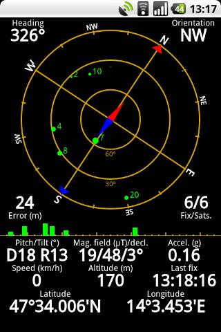
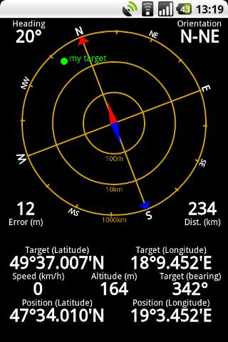
Display your GPS and sensor data: position and signal strength of satellites, accuracy, speed, acceleration, bearing.
Tools included: compass with magnetic and true north, leveling tool, mark or share your location and navigate back later.
Keep your GPS fast: reset it or download A-GPS data regularly for faster fixes.
What's New in This Release:
· Workaround for Nexus S issues.
· aGPS age is correctly displayed (in hours / days).
· Fixed a rounding error in location formatting.
· More instruments for Nexus 7.
· Enhanced landscape layout. All instruments are available in landscape mode, too!
Like it? Share with your friends!
Supported operating systems:
Google Android 1.0, Google Android 1.5, Google Android 1.6, Google Android 10.x, Google Android 2.0, Google Android 2.1, Google Android 2.2, Google Android 2.3, Google Android 3.0, Google Android 3.1, Google Android 3.2, Google Android 4.0, Google Android 4.1, Google Android 4.2, Google Android 4.3, Google Android 4.4, Google Android 5.x, Google Android 6.x, Google Android 7.x, Google Android 8.x, Google Android 9.x
Similar Software:
GPS Logger GPS Logger is an Android application that reads data from the GPS receiver and saves it as a gpx file
GpsTicker Gpsticker is a program for outdoor orientation and navigation with GPS, it is best for hiking and biking. Maps are downloaded automatically from OpenStreetMaps, provided the Phone has an active internet connection
e-Mobile family locator e-Mobile family locator - Easily find friends and family by sending a text message from your phone or web.
Locate device and people
* Locate people and lost device by sending a "locate" text message.
* Generate a ringtone on missing device by sending a "ping" text message
RMaps RMaps is a navigation tool. You can use RMaps as an online map viewer for some popular maps. And as an offline map viewer for your own maps created on the PC.
· Auto rotate map in driving direction.
· Auto rotate map in the northern direction.
· Compass on the map.
· Auto-follow function.
· Online search.
· Full screen mode
Share Path Share Path - Although e-maps and GPS can provide accurate navigation, we are confined on the basis of the existing database. Many times we may go to a place which cannot be found on the e-map. For example, go to a club with friends; on a vacation to the countryside near the lake where we have never been to
Metosphere (Android) Metosphere Explore and create virtual objects around your physical location like messages, emergency alerts, events, news, reviews, games. View geospatial data from Wikipedia, Eventful, and Upcoming. Start a GeoBlog on your GPS-enabled phone.
This is the core Metosphere Android app
Pocket Caddy Pocket Caddy - #1 Golf GPS app: 3D flyover of holes, yardage to greens, shot recording, stats, scorecard, hazard carry or lay up position. Positioning is shot to hole, not cart to hole. Free PC Analytics inc. 3D Google Earth replay with stats, and Free DIY Course Mapping software both available from www.satsportsna
MileageTrac Mileage Tracker MileageTrac Let the Genie Out of Your Android! Automatic Mileage Tracking MileageTrac is a powerful application that uses your devices built-in GPS to automatically track and calculate your auto mileage
amAze (Motorola) AmAze is a first of its kind free navigation and local search service. It is free to download and use and it contains wide coverage of maps including aerial photo in Europe, North America, Australia and parts of Asia and Africa
Other Software by developer «EclipSim Bt.»:
Hungarian for AnySoft Keyboard Kenyelmesen, magyarul irhat az Anysoft Keyboard segitsegevel. Magyar billentyűzet kiosztas es szotar AnySoftKeyboard-hoz. FIGYELEM! Ez egy kiegeszitő, ami csak az eredeti programmal egyutt műkodik. Onalloan nem!


")


")
