TouringNavigation - It is a navigation application program for the motorcycle and the bicycle, etc.
It is a navigation application for the motorcycle and the bicycle, etc.
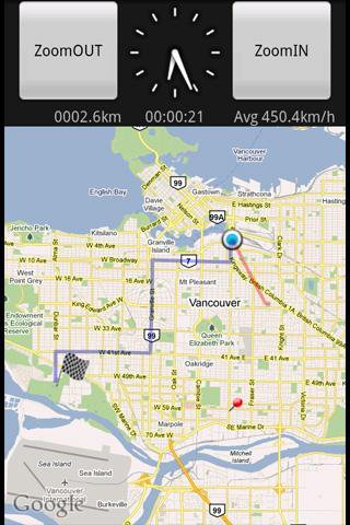
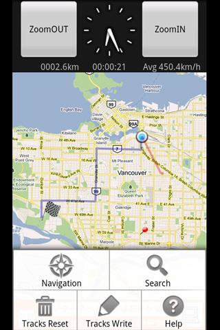
This application displays the route guide, tracks, the mileage that has been passed, the running time , and the mean time velocity.
Tracks that have been passed also provide the function to output to the SD card by the GPX format.(GPS Logger)
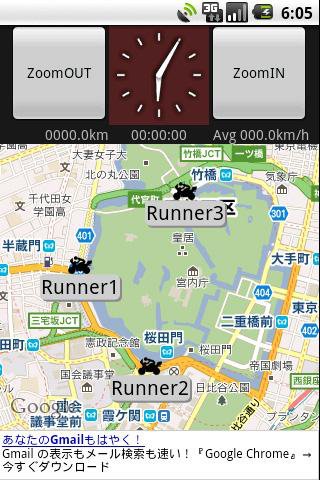
This application provides the location sharing service "Where everyone?".
"Where everyone?" is ability to understand each other, where you are now someone else on the map.
*** Let's try "Where everyone?" ***
Please push Menu button,
and tap the 'Where everyone?' button.
The Input dialog is displayed.
Input keyword 'test' and Tap 'OK' button.
The map is displayed, Please see aroud Tokyo Japan.
you can see 4 test runnners.
Like it? Share with your friends!
Supported operating systems:
Google Android 1.5, Google Android 1.6, Google Android 2.0, Google Android 2.1, Google Android 2.2, Google Android 2.3, Google Android 3.0, Google Android 3.1
Similar Software:
meet-me FREE meet-me With only a few fingertips you can find your friends in the biggest crowd. Their location is presented by a stylish arrow and distance. Awesome: the positions are dynamically updated
NAVIGON MobileNavigator Regional edition DACH for Android NAVIGON MobileNavigator Regional edition DACH for Android - Turn your Android phone into a mobile navigation device with lots of useful functions that will delight you! The pocket navigation device will show you the right way with functions such as Reality View Pro and Lane Assistant Pro
AndNav2 (Android) AndNav2 is a navigation system for Android-powered phones. AndNav2 is based on free mapdata by OpenStreetMap.org. AndNav2 will provide full audible turn-by-turn realtime route-guidance. AndNav2 has unique features, like Text-2-Speech, an accessibility-study (aka 'Where can I get in 30 minutes') or avoiding customizable areas, i.e
ParkLeitSystem ParkLeitSystem is a car-park-routing system. It shows you, according to your GPS position, the nearest city with a car-park-routing system and gives you a list with all available car-parkings and shows how many free places there are. With a click on the parking it switches to google maps and shows you the position of the parking
PhonAlarm PhonAlarm - Start PhonAlarm to make surroundings, friends/family aware of an emergency, and with the GPS location started in your phone, they can immediately locate you. How can PhonAlarm help you and how does it work? If a situation is emerging where you need to be assisted by others, e.g
MileageLedger (Android) MileageLedger is a GPS powered mileage logging application designed for Android enabled phones. The paid version of MileageLedger generates log files that meet requirements of IRS Publication 463, Section 5 which states:
"You should keep adequate records to prove your expenses or have sufficient evidence that will support your own statement
RMaps RMaps is a navigation tool. You can use RMaps as an online map viewer for some popular maps. And as an offline map viewer for your own maps created on the PC.
· Auto rotate map in driving direction.
· Auto rotate map in the northern direction.
· Compass on the map.
· Auto-follow function.
· Online search.
· Full screen mode
SportsTracker (by STL) SportsTracker (by STL) - Share, compare, train and compete in your sport on
http://sportstracklive.com
Live sports tracking from your android phone
http://sportstracklive.com
Beat your personal bests!
Superior GPS sports tracking app. Running, cycling, mountain biking, skiing, snowboarding, sailing, biking, flying, gliding
Metosphere (Android) Metosphere Explore and create virtual objects around your physical location like messages, emergency alerts, events, news, reviews, games. View geospatial data from Wikipedia, Eventful, and Upcoming. Start a GeoBlog on your GPS-enabled phone.
This is the core Metosphere Android app
amAze (Motorola) AmAze is a first of its kind free navigation and local search service. It is free to download and use and it contains wide coverage of maps including aerial photo in Europe, North America, Australia and parts of Asia and Africa
Other Software by developer «kazuhito kawabe»:
not found
Comments on TouringNavigation:
Comments not found
If you noted an error or download link is broken, please, report it via this page or use comments.
TouringNavigation is compatible with your device Google Android 1.5


")


")

")
")
")