TouringNavigation - It is a navigation application program for the motorcycle and the bicycle, etc.
It is a navigation application for the motorcycle and the bicycle, etc.
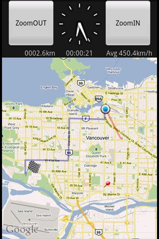
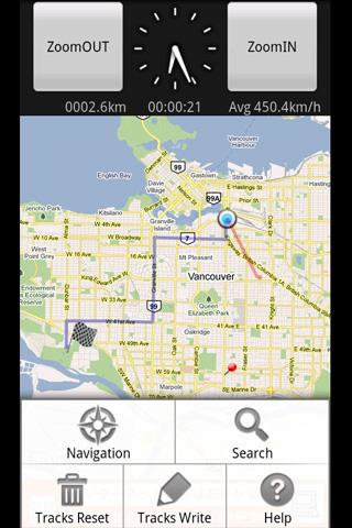
This application displays the route guide, tracks, the mileage that has been passed, the running time , and the mean time velocity.
Tracks that have been passed also provide the function to output to the SD card by the GPX format.(GPS Logger)
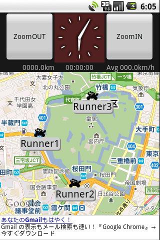
This application provides the location sharing service "Where everyone?".
"Where everyone?" is ability to understand each other, where you are now someone else on the map.
*** Let's try "Where everyone?" ***
Please push Menu button,
and tap the 'Where everyone?' button.
The Input dialog is displayed.
Input keyword 'test' and Tap 'OK' button.
The map is displayed, Please see aroud Tokyo Japan.
you can see 4 test runnners.
Like it? Share with your friends!
Supported operating systems:
Google Android 1.5, Google Android 1.6, Google Android 2.0, Google Android 2.1, Google Android 2.2, Google Android 2.3, Google Android 3.0, Google Android 3.1
Similar Software:
GPShake Lite With GPShake you can track your GPS location, create GPX files, whenever you want with a shake of your phone! This means battery life saving! A great usage example could be when you want to geotagging your photo made with an external camera
Track My Mobile Track My Mobile - Your mobile phone can be Tracked by this applicatio after it get lost
TomTom Australia for Android TomTom Australia for Android - TomTom Australia is a turn-by-turn GPS navigator for Android devices. The app includes accurate offline maps, so you can find your way anywhere, even without an internet connection
amAze (Samsung) AmAze is a first of its kind free navigation and local search service. It is free to download and use and it contains wide coverage of maps including aerial photo in Europe, North America, Australia and parts of Asia and Africa
Android Location Android Location is your free, location-aware, mobile social network.
Meet real world friends. Reveal your location, befriend, and chat with people around you.
Using location-based technologies, Android Location lets you see where your friends are and what they are up to, in real time. Meet people around you. Discover who visits your favorite places
Quovady for Android Quovady is a service that allows you to ask your friends, your family or coworkers "where are you?", let them know of your whereabouts or track their location if they gave you permission to do so
MarineTraffic.com MarineTraffic.com - Real-time ships positions based on Automatic Identification System (AIS). Watch the positions reported by more than 35000 vessels per day on an interactive Google map.
The application provides worldwide coverage of more than 850 ports and a significant number of open-sea areas.
Port arrivals and departures are recorded in real-time
Location Barcoder Location Barcoder is a tool for creating geocoded barcodes based on your location. Barcodes are stored on the SDCard in a folder named LocationBarcodes
TomTom Russia-Baltics-Finland for Android TomTom Russia-Baltics-Finland for Android - TomTom Russia-Baltics-Finland is a turn-by-turn GPS navigator for Android devices. The app includes accurate offline maps, so you can find your way anywhere, even without an internet connection
GPS Widget GPS Widget - This widget simply shows your current location in numbers. Latitude and Longitude are received from the GPS location provider or from the network location provider if GPS is not available.
The altitude is queried from open MapQuest API which yields in a more accurate result than receiving the altitude by GPS
Other Software by developer «kazuhito kawabe»:
not found
Comments on TouringNavigation:
Comments not found
If you noted an error or download link is broken, please, report it via this page or use comments.
TouringNavigation is compatible with your device Google Android 2.2


")


