Android Locationis your free, location-aware, mobile social network.
Meet real world friends. Reveal your location, befriend, and chat with people around you.
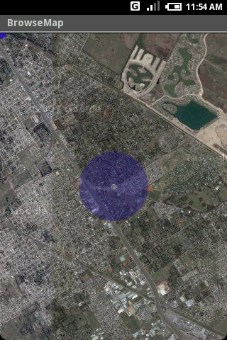
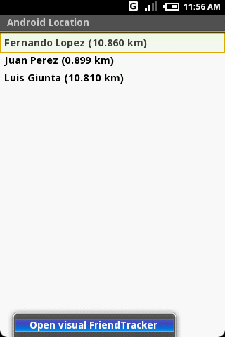
Using location-based technologies, Android Location lets you see where your friends are and what they are up to, in real time. Meet people around you. Discover who visits your favorite places. Join the community in real time.
· Know where you are without having a GPS
· Connect with friends and get alerted where they are nearby
· Explore places and events recommended by friends
· Recommend new places
· Search for stuff to buy in nearby stores
· It runs on any Cell Phone Provider
· It is FREE
Like it? Share with your friends!
Supported operating systems:
Google Android 1.0, Google Android 1.5, Google Android 1.6, Google Android 10.x, Google Android 2.0, Google Android 2.1, Google Android 2.2, Google Android 2.3, Google Android 3.0, Google Android 3.1, Google Android 3.2, Google Android 4.0, Google Android 4.1, Google Android 4.2, Google Android 4.3, Google Android 4.4, Google Android 5.x, Google Android 6.x, Google Android 7.x, Google Android 8.x, Google Android 9.x
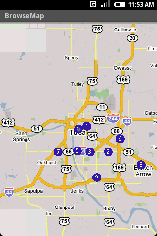
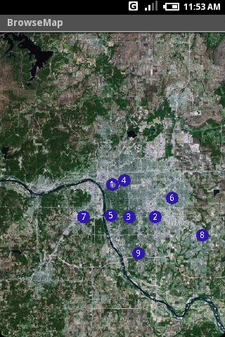
Map Explorer Map Explorer is a prototype that tries to improve map browsing experience. It is basically Google maps with an overlay that shows POIs even if they are beyond the display. Use the preferences to test different visualizations
CoPilot Live Premium UK + IRE (Android) CoPilot Live Premium UK + IRE (Android) - Now there’s a better way to navigate.
CoPilot Live Premium is the essential voice-guided sat navigation app to get you where you need to go, by the way that suits you best.
Detailed street maps of one single European region (e.g
amAze (Sony Ericsson) AmAze is a first of its kind free navigation and local search service. It is free to download and use and it contains wide coverage of maps including aerial photo in Europe, North America, Australia and parts of Asia and Africa
ViewRanger GPS ViewRanger is a unique mapping, navigation, tracking, and information tool for mobile phones that provides fully featured outdoor gps and trail navigation through a natural and intuitive display. ViewRanger transforms a Nokia or other Symbian S60 smartphone into a fully featured trail navigation system
Cell Phone Coverage Map Cell Phone Coverage Map - Test your mobile service for yourself and compare results to other carriers using RootMetrics. Coverage information in the market today is incomplete and gathered infrequently - often no more than once a year - resulting in soft advertising claims of network reliability. RootMetrics is different
Trapster Trapster- Your mobile phone alerts you as you approach police speed traps, red light and speed cameras, via spoken warnings in fun voices! Join world''s largest driver''s social network, 5 million users and growing! Drivers helping drivers! New for 1.6
TTC Subway Rider Efficiency Guide TTC Subway Rider Efficiency Guide - This application has maps of all TTC (Toronto Transit Commission) subway stations so you can see where the stairs/etc are... and plan where to stand on the platform.
Based on ttcrider.ca
Useful for handicapped people too
Sensorly Map Viewer Sensorly Map Viewer - How good is your cell/mobile network coverage where you need it?
Is your favorite WiFi network going to be available at your vacation spot?
See the answer with this application and join us to build worldwide coverage maps.
(Data collection is configurable and can be turned off
GoPenS GoPenS is an OpenSource GPS application for Android phones, based on OpenStreetMap (OSM). OpenStreetMap is a collaborative map of the world. Therefore, one of the main functions of the application is to be able to record a trace and send it as a GPX to the OSM servers, and so edit the OSM Map
Other Software by developer «HS Group»:
not found
Comments on Android Location:
jhackdhanieligama:
Good
Date: 3 Nov 21
If you noted an error or download link is broken, please, report it via this page or use comments.
Android Location is compatible with your device Google Android 7.x


")

")
")


_13470small.png "Trapster")


