Outdoor Speedometer for Android - The Outdoor Navigation software is your best friend through your adventures in the wild.
Go into the outdoors with confidence and enjoy your activities without worrying about the tools to help you navigate. Your Outdoor Navigation app is made by the people who have been developing this software since 2003 across multiple platforms. Be sure that you will stay ahead of the rest with continuous updates and relevant tools.
It is an excellent tool for biking, jogging, skiing, hiking, geocaching, boating, flying and many other sporting activities.
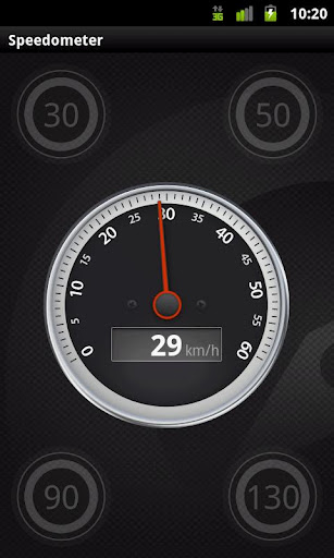
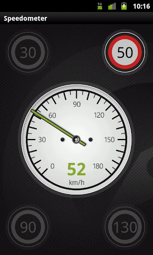
Your Outdoor Speedometer will give you the ability to see your current speed while you are enjoying your favorite activities on large easy to read dial displays. It uses multiple stylish layouts including car, bike, and even a plane.
You will have the ability to quickly set and change your current speed limit and receive accurate sound warnings if you have gone over your desired range.
· Shows current speed
· Car, bike and Plane layouts
· Speed limit tables with selectable speed limits
· Warning beep when speeding over the set limit!
Installation instructions:
Outdoor Speedometer is an add-on for the free Outdoor Navigation application. You need to have your Outdoor Navigation installed to be able to use Outdoor Speedometer.
Download and install Outdoor Speedometer on your Android device. Start the Outdoor Speedometer plugin to complete the license checking: when activation will be completed then the icon will be removed (you need to restart your device to hide the icon) and the plugin will be used inside Outdoor Navigation application.
What's New in This Release:
· Bug fixing
Like it? Share with your friends!
Supported operating systems:
Google Android 10.x, Google Android 2.1, Google Android 2.2, Google Android 2.3, Google Android 3.0, Google Android 3.1, Google Android 3.2, Google Android 4.0, Google Android 4.1, Google Android 4.2, Google Android 4.3, Google Android 4.4, Google Android 5.x, Google Android 6.x, Google Android 7.x, Google Android 8.x, Google Android 9.x
Similar Software:
Elevation and Sea Depth Elevation and Sea Depth displays elevation and/or sea depth in direction of phone.In order to use it properly, hold your phone on flat surface and away from ferrous metal objects and electromagnetic fields
Thermometer for Samsung Galaxy S4 Thermometer for Samsung Galaxy S4 - Thermo measures ambient temperature and humidity using Galaxy S4 inbuilt sensors. App supports Fahrenheit and Celcius. Log readings with a description, which can later be used for filtering. The app displays log as a graph too. Share your location and your reading instantly on to Facebook
Compass3D Compass3D - This augmented reality application adds a 3D compass to the live camera view in real-time.
What's New in This Release:
· Support APP2SD
What's New in 4.0:
· minor fix
What's New in 3.7:
· code optimization
What's New in 3.7:
· minor bugfixes
What's New in 3
GPS Coordinates Converter GPS Coordinates Converter - With this app you can convert GPS coordinates from "degrees, minutes, decimal seconds" to "decimal degrees".
What's New in This Release:
· Locate your phone and show the coordinates
What's New in 2
GeoLog GeoLog saves the sensors data (gps, accelerometer, magnetometer data, etc.) of your device to a log file and calculates the coverage of the site. The coverage is a ratio of the track covering area to the area of the site (expressed in percents)
Smart Compass 360 Smart Compass 360 - Smart Compass 360 is a basic compass application that shows you which direction your phone is pointed. You can use Compass in all outdoor activities as you can think about - walking, sailing, hiking, climbing, camping, flying, reading a map and so much more. Smart Compass 360 is a traveler's best friends
GPS Status & Toolbox GPS Status & Toolbox - Be a GEEK: Get the most out of your phone. Raw GPS data at your fingertips.
Display your GPS and sensor data: position and signal strength of satellites, accuracy, speed, acceleration, bearing.
Tools included: compass with magnetic and true north, leveling tool, mark or share your location and navigate back later
3D Compass (AR Compass) 3D Compass (AR Compass) - 3D compass with augmented reality view, Auto rotate map, Big heading degrees
This is a compass app with augmented reality view and real time map update, and provides real time location information
Android-Speedometer Android-Speedometer - Simple speedometer application and widget for Android.
Tip: on small screens hide timer or compass in settings.
Android-Speedometer features:
· numeric values for: speed (km/h, mph or kn), altitude (from GPS or webservice), cyclometer (km, mi, nm), timer, digital clock, compass, max
Other Software by developer «GPS Tuner»:
GPS Tuner Essentials Full Version with BENELUX Basic Map Content GPS Tuner Essentials Full Version with BENELUX Basic Map Content is designed specifically for off-road use: its large buttons, selectable tool window size, multiple Compass views and the built-in Tele Atlas map makes it extremely user-friendly and reliable
Outdoor Compass for Android Outdoor Compass for Android - The Outdoor Navigation software is your best friend through your adventures in the wild.
Go into the outdoors with confidence and enjoy your activities without worrying about the tools to help you navigate. Your Outdoor Navigation app is made by the people who have been developing this software since 2003 across multiple platforms
GPS Tuner Essentials Full Version with Iberia Basic Map Content GPS Tuner Essentials Full Version with Iberia Basic Map Content is designed specifically for off-road use: its large buttons, selectable tool window size, multiple Compass views and the built-in Tele Atlas map makes it extremely user-friendly and reliable
Outdoor Chart for Android Outdoor Chart for Android - The Outdoor Navigation software is your best friend through your adventures in the wild.
Go into the outdoors with confidence and enjoy your activities without worrying about the tools to help you navigate. Your Outdoor Navigation app is made by the people who have been developing this software since 2003 across multiple platforms
GPS Tuner Essentials Full Version with Canada Basic Map Content GPS Tuner Essentials Full Version with Canada Basic Map Content is designed specifically for off-road use: its large buttons, selectable tool window size, multiple Compass views and the built-in Tele Atlas map makes it extremely user-friendly and reliable
GPS Tuner Essentials Full Version with Baltic Basic Map Content GPS Tuner Essentials Full Version with Baltic Basic Map Content - is designed specifically for off-road use: its large buttons, selectable tool window size, multiple Compass views and the built-in Tele Atlas map makes it extremely user-friendly and reliable
Outdoor Navigation Pro for Android Outdoor Navigation Pro for Android - The Outdoor Navigation software is your best friend through your adventures in the wild.
Go into the outdoors with confidence and enjoy your activities without worrying about the tools to help you navigate. Your Outdoor Navigation app is made by the people who have been developing this software since 2003 across multiple platforms
Outdoor Offline Maps for Android Outdoor Offline Maps for Android - The Outdoor Navigation software is your best friend through your adventures in the wild.
Go into the outdoors with confidence and enjoy your activities without worrying about the tools to help you navigate. Your Outdoor Navigation app is made by the people who have been developing this software since 2003 across multiple platforms
GPS Tuner Atlas Full Version with South America Basic Map Content GPS Tuner Atlas Full Version with South America Basic Map Content is designed specifically for off-road use: its large buttons, selectable tool window size, multiple Compass views and the built-in Tele Atlas map makes it extremely user-friendly and reliable
GPS Tuner Essentials Full Version with Balkans Basic Map Content GPS Tuner Essentials Full Version with Balkans Basic Map Content is designed specifically for off-road use: its large buttons, selectable tool window size, multiple Compass views and the built-in Tele Atlas map makes it extremely user-friendly and reliable


")


