Platforms: iPhone, iPad, iPod Touch, Apple iPhone OS
Categories: Travel & Navigation
Upload date: 19 Oct 11
Developer: VITO Technology
License: Freeware
Downloads: 87
GPS Guide Vokrug Sveta - VOKRUG SVETA GPS-guide, created by VOKRUG SVETA publishing house, is a one-of-a-kind application for the independent traveler. This application allows owners of portable devices with GPS receivers to create exciting and intellectually stimulating itineraries on their very own.
The GPS-guide consists of the VS Guide navigation program and multimedia itineraries.
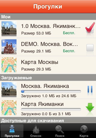
The application consists of two parts: the free-of-charge downloadable Client and the Add-on modules containing comprehensive information about each of a city’s noteworthy neighborhoods or districts. These Add-on modules we call “itineraries”.
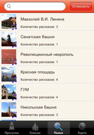
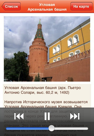
The itineraries are downloaded through the application. Each one includes an audio-guide along with photos of select “places of interest” and their descriptions. When the download of the desired itinerary is complete, a map of the area becomes available.
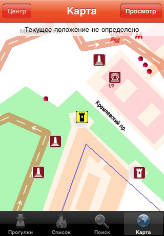
Having loaded the appropriate itinerary, you can set out on a walk as you listen to the virtual guide – your headphones on and the device in your pocket. The application pinpoints your location and draws your attention to all visible “places of interest.” There are no fixed routes. The VS guide adapts automatically to any direction.
The application allows you to look at photos of the nearest "place of interest," read the accompanying descriptions, and locate yourself on the map. "Places of interest" are sorted in a list according to their distance from your location. It is also possible to view them on the map.
The VS guide also has a special “virtual walk” mode for those who like to prepare ahead of time or for those who do not have GPS-receivers. This mode allows you to listen to the audio-guide, look at the pictures, and enjoy all the benefits of travel without ever leaving your home.
Like it? Share with your friends!
If you got an error while installing Themes, Software or Games, please, read FAQ.
Supported operating systems:
Apple iOS 10.x (iPad), Apple iOS 10.x (iPhone), Apple iOS 11.x (iPad), Apple iOS 12.x (iPad), Apple iOS 12.x (iPhone), Apple iOS 4.0.x (iPhone), Apple iOS 4.0.x (iPod Touch), Apple iOS 4.2.x (iPad), Apple iOS 4.2.x (iPhone), Apple iOS 4.2.x (iPod Touch), Apple iOS 4.3.x (iPad), Apple iOS 4.3.x (iPhone), Apple iOS 4.3.x (iPod Touch), Apple iOS 5.0 (iPad), Apple iOS 5.0 (iPhone), Apple iOS 5.0 (iPod Touch), Apple iOS 6.0 (iPad), Apple iOS 6.0 (iPhone), Apple iOS 6.0 (iPod Touch), Apple iOS 7.0 (iPad), Apple iOS 7.0 (iPhone), Apple iOS 7.0 (iPod Touch), Apple iOS 8.x (iPad), Apple iOS 8.x (iPhone), Apple iOS 8.x (iPod Touch), Apple iOS 9.x (iPad), Apple iOS 9.x (iPhone), Apple iOS 9.x (iPod Touch), Apple iPhone OS 3.1.x, Apple iPhone OS 3.1.x (iPod Touch), Apple iPhone OS 3.2.x (iPad)
Other Software by developer «VITO Technology»:
Map of West Virginia (US State) Map of West Virginia (US State) - A map of the West Virginia by VITO Technology. Good for intercity travels with SmartMap.
SmartMap is a mobile device application which uses vector and raster maps. It is compatible with any NMEA protocol GPS receiver (Compact Flash socket, serial port, BlueTooth or sleeve)
Map of Wyoming (US State) Map of Wyoming (US State) - A map of the Wyoming by VITO Technology. Good for intercity travels with SmartMap.
SmartMap is a mobile device application which uses vector and raster maps. It is compatible with any NMEA protocol GPS receiver (Compact Flash socket, serial port, BlueTooth or sleeve)
Geo Walk HD Geo Walk HD Concise Encyclopedia of Surprising Facts at Hand! Discover the world around you with simple and educational application that collects amazing and fun facts about all the most interesting things of our planet
Map of Vietnam Map of Vietnam - A map of Vietnam.
Good for intercity travels with SmartMap.
Layers include:
Towns
Settlements
Airports
Roads
Railroads
Rivers
Inland water
Administrative borders
International borders
Trees
Map scale is 1:1 million.
Good for use with any version of SmartMap. SmartMap can be purchased here
Map of Swaziland Map of Swaziland - A map of Swaziland. Good for intercity travels with SmartMap.
Layers include:
Towns
Settlements
Airports
Roads
Railroads
Rivers
Inland water
Administrative borders
International borders
Trees
Map scale is 1:1 million.
Good for use with any version of SmartMap. SmartMap can be purchased here
Map of Uruguay Map of Uruguay - A map of Uruguay. Good for intercity travels with SmartMap.
Layers include:
Towns
Settlements
Airports
Roads
Railroads
Rivers
Inland water
Administrative borders
International borders
Trees
Map scale is 1:1 million.
Good for use with any version of SmartMap. SmartMap can be purchased here
Map of Rhode Island (US State) Map of Rhode Island (US State) - A map of the Rhode Island by VITO Technology. Good for intercity travels with SmartMap.
SmartMap is a mobile device application which uses vector and raster maps. It is compatible with any NMEA protocol GPS receiver (Compact Flash socket, serial port, BlueTooth or sleeve)
Map of Nebraska (US State) Map of Nebraska (US State) - A map of the Nebraska by VITO Technology. Good for intercity travels with SmartMap and VITO SmartNavigator.
SmartMap is a mobile device application which uses vector and raster maps. It is compatible with any NMEA protocol GPS receiver (Compact Flash socket, serial port, BlueTooth or sleeve)
VITO SystemTools Discover new possibilities of your Pocket PC hardware buttons!
GoodWin GoodWin is a next generation touch oriented Windows Mobile launcher and task switcher for Pocket PC.
Launcher and Task Manager
GoodWin is a touch-oriented Windows Mobile launcher and task manager.
GoodWin is a complete replacement for Today screen and Start Menu


")
")


")
")

